
The early taste of winter will continue through at least the first week of December. In fact, some of the longer range models suggest the below normal temperatures will continue through Christmas. While we have seen lots of cold recently, we haven’t seen much in the way of precipitation. That should change by early December when a number of factors should come together to produce a major winter storm.
Current conditions show why much of the Mid-South experienced snow flurries on Thursday. The air mass currently settling over the region is a true arctic air mass and will be one of the coldest air masses relative to normal that we will see this winter (minus 16 to minus 18 Friday and Saturday relative to normal). Cross-polar flow is set up, which allowed this air mass to move southward from the north pole (look at the wind direction aloft — it leads straight to the north pole). Morning lows on Saturday will be in the teens. After a frigid start to the weekend, temperatures Sunday should moderate to only a few degrees below normal. The next system will ride down the trough on Monday, which will bring warm-advection rain showers during the day that could end of snow showers Monday night, especially in the Bluegrass. This system will bring some cP air into the state Tuesday, but this air mass will not be nearly as cold as the current one (note the lack of cross-polar flow).
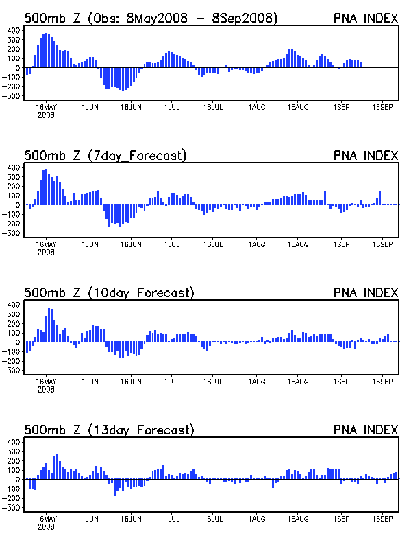
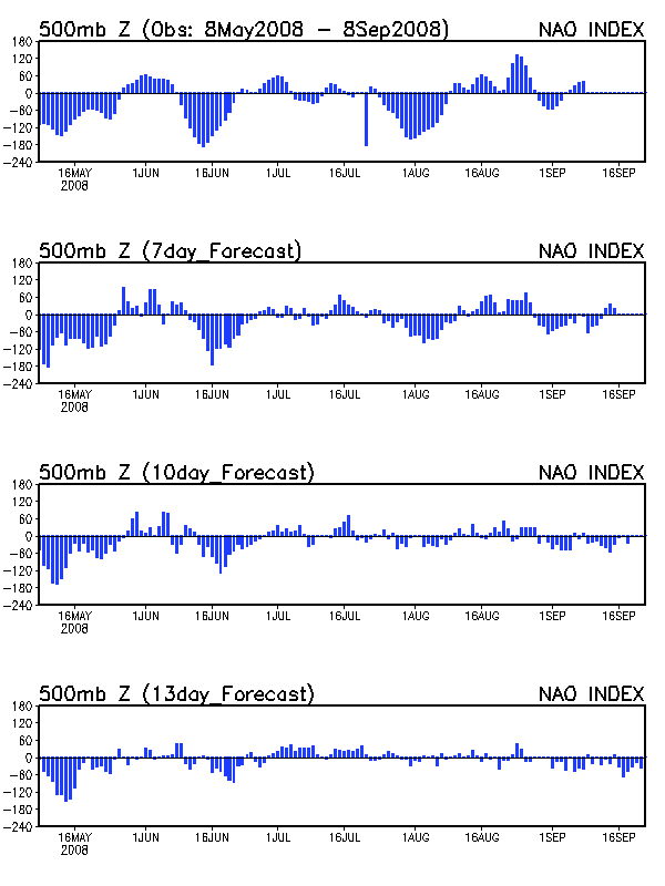
Yet another storm will spread rain showers across the Mid-South around Thanksgiving day. The days surrounding Thanksgiving will be the warmest days of the extended period but temperatures will likely remain below normal (lower 50s). This Thanksgiving storm will set the stage for the potential major winter storm during the first week of December. By the end of November, cP air will overspread the U.S. east of the Rockies, which will allow for a more southerly storm track for upcoming storms. At the same time, an anomalous positive PNA and negative NAO pattern will allow a lobe of the polar vortex to sink southward into southern Canada. This combination of a southern storm track, blocking ridges off the coasts, and arctic air trapped over southern Canada is the perfect pattern for a major winter storm due to the strong thermal gradient. This strong baroclinic zone along the Pacific ridge will spawn a 200 kt jet streak that will be the trigger for the big storm. How will this play out?
There is no way to know exactly what track this storm will take. The GFS runs of the past several days show any number of possibilities (6z, 12z). It wouldn’t surprise me if there were more than one storm, since this type of pattern typically has multiple short waves ejected from the trough. While there is blizzard potential from this pattern, the most likely result for the Mid-South will be heavy rain. With Neutral ENSO conditions and a cold PDO, a storm track over the central plains and into the Midwest is the favored pattern, which will keep KY and TN on the warm side of the storm. That is, until the cold front passes by and fresh arctic air spills into the region.
The fly in the ointment for this pattern is the cut-off low off the coast of California. The European shows this feature well in the day 8-10 composite. The GFS suppresses this low well of the coast which allows the arctic trough to develop over the Southwest. The European brings the low ashore, which could potentially lead to a more zonal pattern.