
Moisture will continue to move north off the gulf of Mexico into our region on the backside of a high pressure for Thursday and Friday allowing for a chance of isolated non severe storms both days. Summertime temperatures again will be common with highs in the upper 80’s, high relative humidity values will also contribute to make it feel uncomfortable outside. Another surge of heat will head into our region for this weekend with highs in the low to mid 90’s and heat index values from 101-106. Only isolated non severe storms will occur this weekend as well. Allow extra caution if outdoors for long periods of time this weekend due to the heat.
– Looking further down the road the heat wave should reach it’s peak early next week before seeing a break ( mid to upper 80’s for highs for the end of the week). We may however see another heat wave the last week of the month as well, some of the latest long range modeling the ECMWF model in particular is suggesting several heat waves and well above normal temperatures into the middle of July.
Here is a recap of the summer forecast issued on May 31st.
Write-up is for Kentucky, maps are national based.
First let’s take a look at the analogs, past years that had similar conditions to this one heading into the summer.
2007, 2005, 1998 and 1995.
– 2007 featured a very dry may around here but was a good match with the enso state the same can be said with 2005. 1998 and 1995 featured wet months of May. There two things in common with all 4 years, very hot months of August and very active hurricane seasons. Those will be the highlights of this summer.
June -short-term modeling other than the US model, the CFS indicates ridging from the southern plains will make a run or two throughout the month at the lower Ohio valley leading to a threat of a short heat wave or two by mid to late June. At the same time several strong frontal system should give the great lakes and northeast some refreshing Canadian air from time to time. There will a be an almost constant battleground which will near our area for the month which means there will be higher than normal thunderstorm activity. Several severe events are likely some in the variety of squall lines others are mcs events along warm or stalled fronts. Overall expect June to be slightly warmer than average and wetter than normal.
July- I expect July to be about a normal month of July for the region both in terms of precipitation and temperature. Although normal will be the sum at the end variability should still be expected.
August -All four of the analog years had a very hot with august with readings near 100 many days in 2007 but that was very dry as well, so it’s not likely to get that hot (6* above normal) but above normal temperatures are likely with several heat waves. With the potential to be in the main ridge of heat by August precipitation frequency should decrease somewhat as well which may favor below average precipitation.
Tropics
– again all 4 of the analogs had very active tropical seasons in the atlantic with 2005 being the #1 season on record.
– the tropical waters from the gulf to the Caribbean are very warm for this time of year
– the euro seasonal model has continued to indicate for several months below normal pressures for the tropical season in the gulf, Caribbean and atlantic off africa.
my forecast
– 16 to 21 named storms
– 9 to 11 will be hurricanes
– 3 to 6 will be major hurricanes
MAPS
nationwide temperatures summer 2010
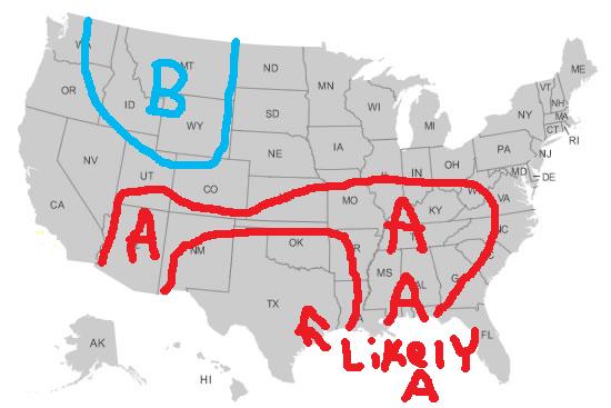
Overall there should be some cool weather over the northern Rockies. The main ridge of heat should be over the southern plains and flex northeast from time to time particularly in June and August. Regions not highlighted are near normal in terms of temperatures.
precipitation summer 2010 compared to normal

Above normal precipitation is indicated in the southeast due to tropical activity and below normal under the heat ridge in the southwest away from the monsoon. Another area of above normal precipiation will be present with the ring of fire pattern and battleground to the north of the heat ridge.
Hurricane tracks 2010

the southern plains ridge should lead to one track into Mexico. Other tracks should be from the central and eastern gulf northeast with another track where storms may come close to the east coast.
Kentucky recap
Temps- slightly above normal ( warmest to normal in mid to late June and August)
Precip- near normal
For more on your state or location feel free to e-mail me mitchehll.gaines673@wku.edu.