Highlights
-Big Warm-up through Tues.
-Severe weather potential Tuesday Night into Wed.
-Heavy rain not out of the question Tues. night into Wed.
Forecast
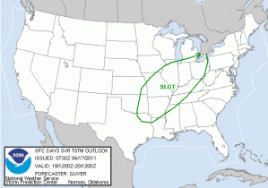
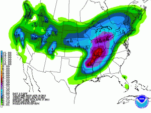
As the trough that affected last weekend’s weather moves offshore, a ridge has begun to build across the south and temperatures will rebound under southerly flow with high temperatures on Monday reaching the upper 70’s. Monday Night a stray shower or thundershower cannot be ruled out as moisture continues to stream in and overnight lows only dip down into the mid 60s. The bigger story is on Tues, where temperatures will continue to climb as a surface low pressure moves out of the plains and into Missouri. The warm sector of this mid latitude cyclone is more early summerlike, as temps will climb into the upper 80’s, with abundant moisture in place. There will be a chance of rain Tues. ahead of a cold front that is forecasted to move through our region late Tues. Night into Wed. Severe weather is likely associated with this cold front; however more details will follow as this system approaches. For now, the Storm Prediction Center has placed our region under a slight risk, but this risk may be altered depending on how the system progresses.
Make sure you keep updated through Tues. on any changes.
The front should be through our area by Wed returning temperature to a more seasonable range of around the low 70’s.