Current conditions.

We have a closed upper level low moving through the region with a weak frontal boundary. Ahead of it we’re seeing a strong advection of moisture warmth and even some slight instability. The enviroment is highly sheared now and has me concerned that we could see some isolated storms overnight and Wednesday morning. These storms could produce brief weak tornadoes and strong winds. Overall the instability is very week under 300 j/kg CAPE making this threat very isolated with the best chance in southern KY. Temperatures should steady in the 50′s overnight with some low 60′s south for BG region. Outside of any storms showers will be widespread ahead of the system. my thinking now is for winds of 15-25 mph with the frontal passage, a little more aggressive than earlier thought to the strength of the low-level jet. temperatures should fall though the 50′s and into the 40′s behind the system Wednesday night with clearing conditions. SPC outlooks have the region in a see text for overnight and early Wednesday.
Thursday another weaker disturbance will move through the region. Another period of rain is likely. This is large part due to ample amount of lsentropic lift ahead of it. Mixing ratios will be around 5 g/kg which would yield around 1/2 inch rain on average. This should be a steadier rain than tonight’s with no convective threat. Temperatures will be in the 40′s across the region perhaps near 50 in BG Thursday.
isentropic map


The tighest graident is from AL into east KY showing the best lift.
We will be between systems once again. The overall pattern of a southeast ridge and a slight trough in the Rockies continues with frequent systems tracking over the Ohio valley.
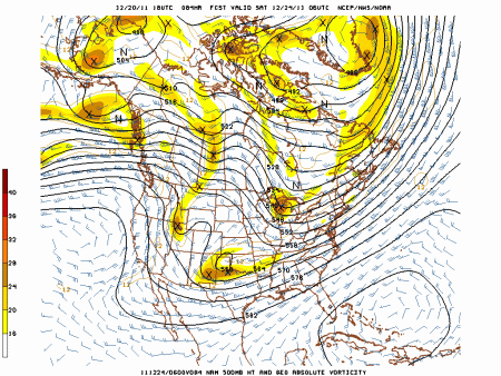
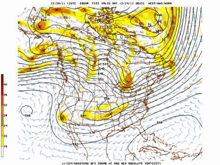
After this many of you boys and girls out there are wondering if the prospects for a white christmas have changed. If you only follow the GFS model then you would say no. However Other more reliable modeling says yes, by the way the US GFS is 4th among accuracy of meteorological models. Not very good. I’m becoming more confident in a storm occurring however temperatures are questionable as to supporting snow. Bad news is the model which I think makes the most sense given the pattern has to be obtained through paid access and I can’t show much of this model. However we can compare the NAM and GFS out at 84 hrs with regard to the upper levels. Remember the pattern has been for slowing moving systems than modeled in recent months. Also notice how the GFS really shears out the upper level energy, GFS bias is to have the pattern move to quick. The NAM image is a very close match to the ECMWF 500 mb image for Saturday morning.
NAM Saturday morning
GFS
The energy digging into the trough forms a storm christmas eve over the south which tracks northeast from Saturday night to Monday. Precipitation type will be trickier to pan down. dynamical cooling could lead to a mainly snow event as some colder air works in. However temperatures on the 12z ECMWF are in the upper 30′s for most of the storm which would yield rain. Still plenty of time to iron out the details.
Daily forecast average of all locations in the state east of I-65.
Wednesday: AM showers 80%, isolated strong storms, breezy winds 15-25 mph in the morning. temperatures falling from 55-60 to 45-50 in the afternoon.
Thursday: still cloudy periods of rain 80% lows in the low 40′s highs 45-50.
Friday: mostly cloudy lows in the lower 40′s highs in the upper 40′s.
Saturday: mostly cloudy lows in the lower 30′s highs in the mid 40′s
Sunday: rain and/or snow likely 60% lows in the mid 30′s highs in the upper 30′s, don’t count out a white Christmas.
Again the temperature and precip chances mainly follow the ECMWF and CMC models past Friday.
I’ll update as needed on any storms overnight or Wednesday am.
MWG


new CMC more in line with GFS with a sheared out weeker vort max which is more progressive this weekend. no storm.
My view of the overall pattern still favors the storm. We’ll see what the 00z ECMWF has to offer overnight.
bulk shear values and instabilty increasing. Rumbles of thunder possibile overnight with very isolated severe threat for damging winds still present. LLJ may contribute to stronger gusty winds in showers. Otherwise still expecting winds of 15-25 mph overnight and steady temps near 60.