
Days at a Glance:
Thursday: Begin the day at 66 degrees with clouds building throughout the morning before scattered to widespread rain showers enter the area by early to mid-afternoon. Accumulations of .10 – .20 of an inch are anticipated area-wide with higher values locally possible. Clouds will stick around throughout the day and clear into the overnight hours. Temperatures will reach 87 before dropping into the afternoon. Winds will be light around 5-6 mph switching from SSW to NW by mid-afternoon.
Friday: Sunrise will be 59 degrees with patchy fog clearing off fairly quickly after daybreak. Sunshine will dominate with fall-like air and temperatures reaching 78. North winds will be persistent and strongest in the afternoon at 12-17 mph before slacking overnight.
Saturday: Beginning the day at a chilly 45 degrees. Sunshine and fall-like air will once again dominate with temperatures reaching 70. Winds will be persistent from the NE at 10-12 mph.
Sunday: Another chilly start at 49 degrees. A sunny morning will give way to clouds into the afternoon hours that will persist into the evening. Isolated light showers are expected if any precipitation at all. At best, accumulations will be a trace – .05 for the area. Temperatures will reach 79 with slight mugginess returning. Winds will be from the south at 5-6 mph before becoming variable by the evening.
Discussion:
The storms were as advertised this afternoon being isolated in nature, but Bowling Green took a direct hit by a strong storm in particular. Frequent lightning, minor flooding on roadways due to heavy rain, and brief gusty winds were the major outcomes. The Bowling Green Regional Airport recorded 1.86 inches of rain with 1.59 of that falling within one hour or less. The WKU Farm Mesonet station only recorded .67 inches, which speaks to the localized nature of precipitation associated with “pop-up” or ordinary cell thunderstorms. Both stations recorded 20 mph gusts.
|
|
| An improvised waterfall down a flight of stairs in front of the Industrial Education Building (IEB) on WKU’s Campus. Picture courtesy of STN Board Member, Will Paschall, from inside IEB. This was during the peak of today’s heavy rainfall. |

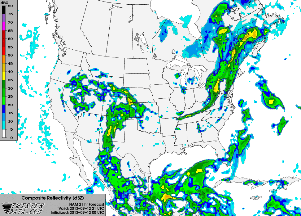
If you are tired of this uncomfortable, sticky heat, then you are in for a treat. The cold front mentioned in Sunday’s forecast is projected to pass the area tomorrow afternoon. Scattered to widespread showers will bring .10-.20 of an inch of area-wide rainfall with locally higher amounts possible due to embedded thunderstorms. Severe weather is not expected, with localized lightning and heavy rain the major threats.
|
|
| NAM 21Z (4PM CDT) Composite Reflectivity for Thursday roughly indicating the rainfall associated with the cold front (thin horizontal green band spanning the KY/TN border) to be through our area. |
Clouds will stick around and dissipate overnight. While relief will not be immediately felt, cooler and much drier air will begin to rush into the area overnight Thursday and all day Friday. It’s time to dust off your jackets because Friday and Saturday night will be rather chilly in the mid to upper 40’s by daybreak on Saturday and Sunday respectively. Sunshine will dominate Friday and Saturday with temperatures in the high to low 70’s respectively, but clouds will build into the area once again Sunday afternoon with little to no rain anticipated. This is associated with a very weak and dissipating cold front.
Get out and enjoy the comfortable, beautiful weather in store this weekend as fall makes a pleasant surprise!
Forecaster: Austin Boys