Wild Weather Wednesday

Today’s Forecast

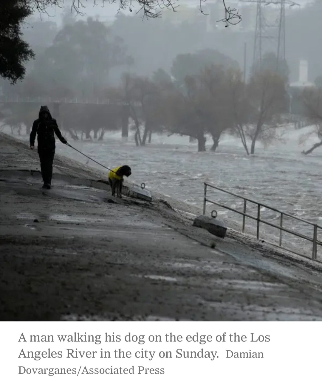
Good morning and happy Wednesday! As most of the severe weather came through last night and early this morning, I hope everyone remained safe and has minimal damage! The severe threat for the day is mostly gone, but gusty winds and rain will continue through most of the day. A wind advisory is still in effect until 3pm (CST). Once storms have passed through it will be cloudy and cold, with temps dropping throughout the day. Luckily, tomorrow will be sunny with light winds. Temps will be cooler with highs in the upper 40s and lows in the mid 30s. Going into Friday, there is a chance for some more showers to return, so make sure to enjoy the sunshine tomorrow!
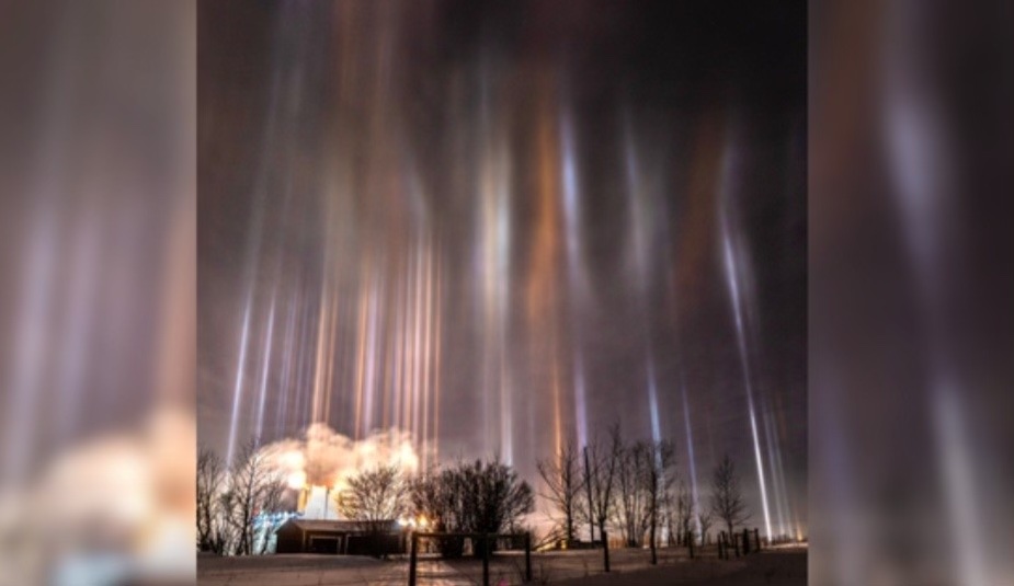
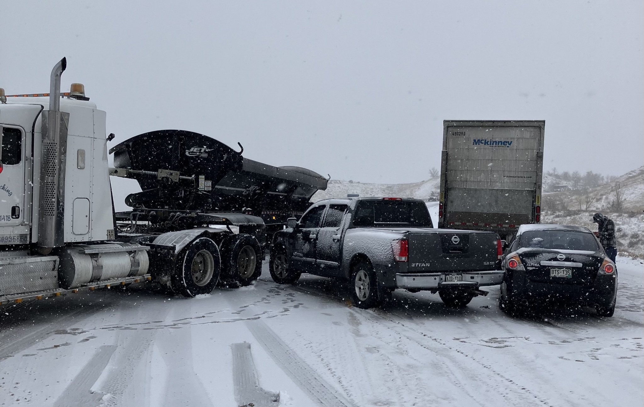
Recent Wild Weather

This week in wild weather a fierce snow squall hit the Denver area. The craziest part of all of it was that less than 24 hours prior the daily temp sat at a warm 64 degrees. The storm began at light flakes falling, but would eventually turn into complete white out conditions. This left driver’s with zero visibility and icy road conditions. There were several accidents reported including a multiple vehicle pile-up. This particular snow squall was caused by a powerful cold front that swept through Denver bringing with it very heavy wind gusts and dropping more than 2 inches of snow per hour. With Denver being the wildest city for weather it isn’t all that shocking. However, it still comes with many challenges as local residents are caught off guard by this fast-moving and sometimes unpredictable snow event. A Snow Squall Warning was in effect until 10:30 a.m. Tuesday and ceased on Tuesday at 10:45 a.m. Most snow squalls only last 30 minutes to an hour, but they pack a punch in a small amount of time. Most of Denver will see a total of a foot of snow and possibly two feet in some mountain regions. The National Weather Service has issued a Winter Storm Warning and Avalanche Warning for portions of the mountains, especially areas above 9,000 feet.

Wild Weather this Day in History

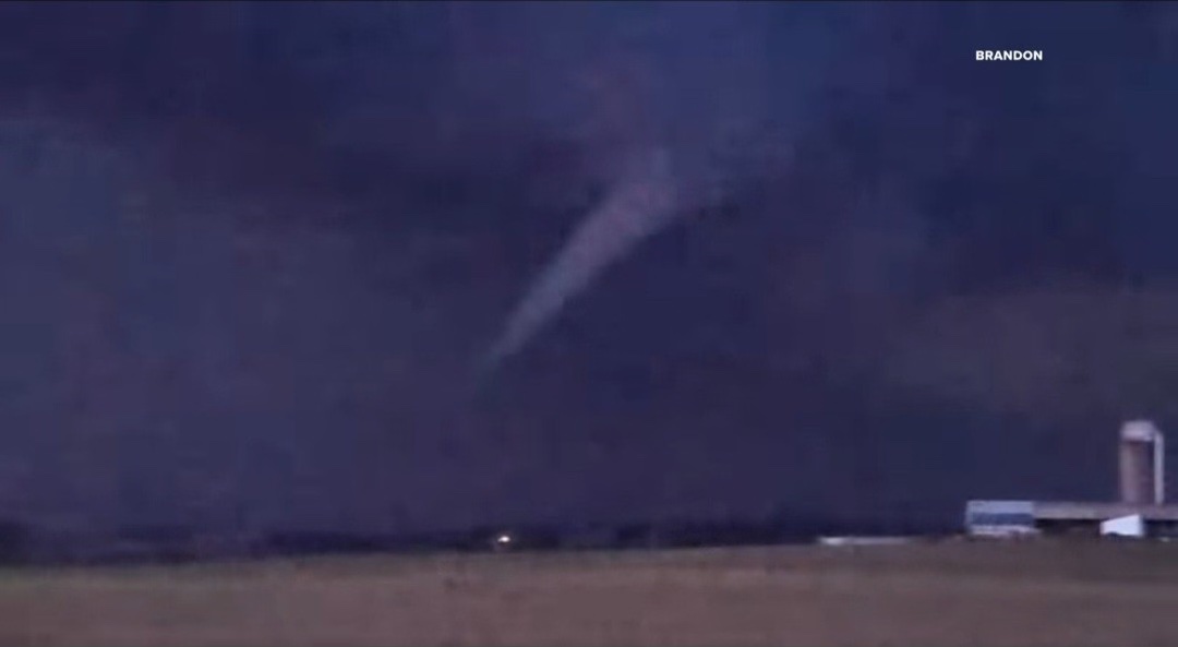
While many experienced severe storms last night through early this morning, let’s take a look back at a very powerful low pressure system that ripped through southeastern Kansas on February 28th, 2007. This low pressure system, that tracked into the plains, produced 3 different tornadoes that later merged into 1 large tornado. With mostly EF0s and EF1s reported, this large tornado was rated to be an EF4, making it the first EF4 tornado of the newly implemented Enhanced Fujita Scale (which became operational on February 1st, 2007). These storms erupted around 5pm, producing severe hail, and intensified into a supercell around 6:30pm, producing many of the tornadoes. These storms continued until 9:30, when reports of penny sized hail were still coming in.

I hope everyone has a great rest of the week and can continue to stay safe as rain and wind continues to rip through!

Sources: https://www.9news.com/article/weather/weather-colorado/winter-weather-snow-colorado-denver-forecast/73-3aff0492-0ffb-4c67-b9be-fb8752a08c90 https://www.weather.gov/ict/event_20070228

Posted in Kentucky Weather | Comments Off on Wild Weather Wednesday

Wild Weather Wednesday

Today’s Forecast

Good morning and happy Wednesday! I hope everyone has had a great week so far and enjoyed the much needed sunshine! Unfortunately, the sun will go away for tomorrow, bringing with it gusty winds and rain. For today though, we do get another batch of beautiful weather. With a high of 67, light gusts increasing to heavier gusts will start to bring in some clouds as we head into the evening. As the rain begins to move into our area we see a slight chance for showers tonight. Heading into tomorrow, the chance for showers ramp up, with the biggest chance during the afternoon. These showers can contain some storms with winds as gusty as 30mph. With high winds any loose or unsecured items are able to be blown around, so make sure to secure anything that might be loose outdoors. Luckily, storms will die off throughout tomorrow night, leading to a beautiful and sunny weekend with highs for Friday in the mid 50s and highs for Saturday in the lower 50s.

Recent Wild Weather

This week in wild weather something happened that brings all the weather nerds (like me) a lot of joy! If you ever saw the famous thundersnow video with Jim Cantore, then you know what I’m talking about. On Sunday in Upstate New York, near white-out conditions were occurring during a snowstorm. This snow storm brought with it 6″ of heavy snowfall, 40 mph wind gusts, lightning, and yes,  thunder! Thundersnow can occur anywhere heavy snow is falling, and the NOAA National Severe Storms Laboratory says it can also be observed downstream of the Great Salt Lake and Great Lakes during lake-effect snowstorms. Although thunder and lightning are typically associated with thunderstorms, and while rare, there is always the possibility to hear it accompanied with a snowstorm.

Wild Weather this Day in History

On February 21, 1918, a record breaking temperature increase happened in Granville, North Dakota. In the early morning hours the temperature hit it’s low for the day at 33 degrees below zero! By the time afternoon arrived it would climb an impressive 83 degrees bringing the high for the day to 50 degrees. It probably felt like they were having a heat wave after the very frigid night they had just experienced. This quick warm-up was caused by Chinook winds. Chinook winds are a region-specific term used for Foehn Winds in the lee of the Rocky Mountains in the United States; Foehn Winds are warm, dry winds that occur in the lee of high mountain ranges. It is a fairly common wintertime phenomena in the mountainous west and in parts of Alaska.

I hope everyone has an amazing rest of the weekend and stays dry tomorrow!

Sources: https://www.foxweather.com/learn/thundersnow-what-causes-lightning-and-thunder-during-a-snowstorm.amp https://www.washingtonpost.com/climate-environment/2022/11/18/how-thundersnow-happens-explained/ https://forecast.weather.gov/glossary.php?word=CHINOOK#:~:text=Chinook,and%20in%20parts%20of%20Alaska

Posted in Kentucky Weather | Comments Off on Wild Weather Wednesday

Happy Monday! 2/19

Happy President’s Day everyone! Did you enjoy the cold this weekend or the brief snow? Well, with how the forecasts are looking, we will not get any more snow for the rest of the spring. With kids having today off, today would have been a great day to get out in the sun! The forecast ahead looks great for spring lovers!

Monday Night: Partly cloudy with a low of 30 degrees.

Tuesday: A high of 61 degrees with partly cloudy skies. A slight breeze out of the south throughout the day.

Tuesday Night: Clear skies with a low of 35 degrees.

Wednesday: Partly cloudy skies with a high of 67 degrees, winds out of the south with gusts up to 20mph.

Wednesday Night: A warm night with a low of 54 degrees and cloudy skies.

Thursday: Scattered rain showers in the morning becoming more widespread rain in the afternoon, thunderstorms possible. A high of around 61 degrees with wind gusts up to 20mph.

Thursday Night: Scattered thunderstorms overnight with a low of around 44 degrees.

Friday: Sunny with a high of around 55 degrees.

Friday Night: Clear skies with a low of around 35 degrees.

Saturday: Sunny skies with a high of around 52 degrees.

Saturday Night: Clear skies with a low of around 35 degrees.

Sunday: Partly cloudy skies with a high of around 65 degrees. This is beginning to be the time of year when pollen allergies become a problem. So keep an eye on the pollen levels.

Posted in Kentucky Weather | Comments Off on Happy Monday! 2/19

Wild Weather Wednesday

Today’s Forecast

Good morning and happy Valentine’s Day! Some areas will see patchy fog this morning, but a beautiful Wednesday is in store! With sunny skies and warm temps, highs will get into the lower 60s with lows later tonight in the lower 40s. Tomorrow will continue to be sunny and warm with highs in the lower 60s and lows in the upper 30s. Heading into this weekend things start to look cooler and wetter. Friday will be partly sunny and then a slight chance of rain shows up later that night. Highs will be in the lower 50s and lows will be in the upper 20s, which could lead to the potential for snow. Going into Saturday, once any precipitation moves out of the area, it’ll be mostly sunny with highs in the upper 30s.

Recent Wild Weather

This week in wild weather a rare winter storm made is way through southern Wisconsin on Thursday. This massive storm left a path of destruction that included dead and missing cows, roofs blown off of homes, destroyed storage sheds and barns, downed power poles and trees, trashed vehicles and shattered windows. Luckily, there were no deaths to report or even serious injuries (which is quite remarkable. February tornados are nearly unheard of, especially in the Northern States. This left most residents and local business owners in shock. Wisconsin has been experiencing a much warmer winter than usual, registering even 25 degrees higher than average. Some believe that the summer-like temperatures are what caused this unusual weather event. This was the state’s first recorded tornado in the month of February, according to Taylor Patterson, a meteorologist at the National Weather Service in Milwaukee. Records date back to 1948.

Wild Weather this Day in History

This weeks look back in weather history for February 14th… takes us to the “The Saint Valentine’s Day Blizzard.” A winter snow storm that buried New England with 8 foot snow drifts in 1940. Lots of different writers and story-tellers over the years have stated that instead of getting hit with cupid’s arrow for Valentine’s Day, New England was hit with 60 mph wind gusts and 14 inches of snow. The storm hit parts of Massachusetts, Connecticut, and Rhode Island. The storm began at about 3 p.m. on Valentine’s Day and began causing havoc during the evening commute. It made it impossible for anyone to get out and celebrate the holiday with cars stranded on the roadways and traffic at a standstill. The storm continued for the next nine hours without letting up. Many people living and traveling through the area were caught off guard because the Weather Bureau had been predicting “rain and light snow” for that day, claiming that the worst of the storm would stay off shore. Residents of New England would have a different story to tell, and that included the fact that 31 lives were claimed due to this storm and its unexpected arrival.

I hope everyone has an amazing rest of the week and enjoys the sunshine and warmth before it cools down this weekend.

Sources: https://apnews.com/article/wisconsin-first-february-tornado-storm-7362a8772cd1e953240a1966b2611ec4 https://www.kare11.com/amp/article/weather/wisconsin-hit-with-its-first-ever-february-tornado/89-1a6679e5-87e5-437d-97fc-5084b662e70b https://www.farmersalmanac.com/the-saint-valentines-day-blizzard-18213

Posted in Kentucky Weather | Comments Off on Wild Weather Wednesday

Wild Weather Wednesday

Today’s Forecast

Good morning and happy Wednesday! I hope everyone has had an amazing week so far and has enjoyed some of the warmer temperatures! Today will hit the warmest it has been in a while with highs in the lower 60s and mostly sunny skies. Lows will be in the mid 40s with mostly cloudy skies throughout the night. With a shortwave shortly moving into the area, chances for showers start to go up starting Thursday night. Throughout tomorrow cloudiness will increase, with highs in the lower 60s and lows in the lower 50s. Into this weekend, temps remain in the lower 60s with continuous chances for rain.

Recent Wild Weather

The wildest weather this week could be found in Southern California, with the hardest hit area being Los Angeles. Torrential rains and hurricane force winds made their way into the area when a powerful atmosphere river storm hit. Atmospheric river storms are created when wide-reaching plumes of moisture act as a firehose, loading up with warm air from the tropics and unloading them both drenching the land with rainfall. These types of storms are very popular on the West Coast. This system is currently causing major, downed trees, flooding, and mudslides to occur. Rainfall totals over the 4th and 5th of February hit just over the 12″ mark, making this the third wettest consecutive two-day total since official weather records began in 1877, and the highest two-day rainfall total for the month of February. There have been 4 deaths associated with this storm, and more rainfall is still expected in the futurecast. There are evacuation orders or warnings in place in Los Angeles, Ventura, Orange and San Bernardino counties.

Wild Weather this Day in History

On February 7, 1959 a man named Gary was rushed into the emergency room with frozen hands, feet, and arms. He had spent the night in his car in subzero temperatures. Subzero temps in the U.S. is any temperature reaching below 0° Fahrenheit. It is never safe to attempt to stay in your car overnight in these kinds of weather conditions, but in dire circumstances you should always be prepared just in case. First, make sure your vehicle is prepared for travel in the winter. You can do this by checking that your battery, lights, heating/cooling system, windshield wipers, and tires are all in good working condition. You should also make sure that you have any necessary supplies should you get into an accident or become stranded. These supplies can include: an ice scraper, snow shovel, something to catch traction (many people suggest kitty litter), flashlight, blankets, water, non perishable snacks, first aid kit, reflectors, etc. There are lots of helpful resources online to help you further decide how to best prepare for travel during the frigid winter months.

I hope everyone has an amazing rest of the week and stays dry from any rain that moves in!

Sources: https://www.nytimes.com/2024/02/05/us/california-atmospheric-river-flooding.html https://www.latimes.com/california/story/2024-02-05/california-storm-weather-los-angeles-2024

Posted in Kentucky Weather | Comments Off on Wild Weather Wednesday

Happy February Everyone!

Welcome to February, we are one more month closer to spring! The groundhog saw his shadow so according to him we are in for an early spring. The models indicate that we may be in for another round of winter temperatures in late February, and the models agree with this! Which is rare, so be prepared for one last blast of winter. Now let us look at the forecast for the week ahead.

Tuesday: Partly cloudy skies with a high of around 56 degrees as a high with mostly clear skies at night with a low of 32 degrees.

Wednesday: Partly cloudy with a high of 60 degrees with a low of 45 degrees and mostly clear skies at night.

Thursday: High of around 60 degrees with cloudy skies. That night expect rain showers to move in the evening with rain moving in overnight, low of around 50 degrees.

Friday: High of around 67 degrees with scattered rain showers throughout the day and through the night. Otherwise, mostly cloudy through the day with a low of around 50 degrees.

The Weekend: Cloudy overall with rain chances mostly on Sunday, with highs around 60 degrees. The weather for the weekend is going to be warm and cloudy so maybe a good weekend to wash a car. After this weekend we start to see the temperatures dropping again.

Posted in Kentucky Weather | Comments Off on Happy February Everyone!

Wild Weather Wednesday

Today’s Forecast

Good morning and happy Wednesday! I hope everyone is having an amazing 2024 so far! Today will be another cool and rather cloudy day with highs in the mid 40s and lows in the lower 30s. Luckily, no precipitation is expected, so it should stay dry! Tomorrow will be much like today, but, with some more sun peeking out, we’ll see some warmer temps with highs in the upper 50s and lows in the upper 30s. Moving into the weekend, temps continue to rise and the sun continues to come out, that is until Saturday night. Saturday night into Sunday there are some slight chances for rain, but temps should remain in the upper 50s.

Recent Wild Weather

A rare and breathtaking phenomenon that I’ve featured previously on a “Wild Weather Wednesday” post made another spectacular showing last week just outside of my hometown of Knoxville, TN. In the small town of Gatlinburg, TN located in The Great Smoky Mountains, light pillars could be seen hanging against the night mountain landscape. Debra Martin Gillespie captured photos of the lights, and said that she just could not stop taking photos. Light pillars are created as ice crystals slowly fall or are suspended in the atmosphere, and during that process catch and reflect bright lights that shine onto them. In this case the lights from the city below were reflected upwards, with the bright blue light coming from a popular local theme park “Anakeesta”. Many of the other lights that you can see came from downtown Gatlinburg, and cabin resorts nestled inside the mountains. Some believed it to be the Northern Lights since they will be the brightest that they have been in 2024, then they have been in the past two decades. This is because the current solar cycle will reach its maximum activity, providing the ideal conditions for the creation of the most spectacular and visible northern lights from larger regions of the Earth. I recently celebrated my 21st birthday in a cabin in Gatlinburg with family and friends, and absolutely hate that I missed this once-in-a-lifetime light show.

Wild Weather this Day in History

With all of the recent snowfall events in and around the US, it only made sense that this week’s “Wild Weather this day in History” would focus on just that. In the winter of 1966, a massive blizzard would hit New York and leave it absolutely paralyzed. Winds gusting up to 60 mph and temperatures dropping into the teens made for frigid conditions. Along with the gusty and heavy blowing winds, blizzard conditions were certainly in full effect. It crippled the train service, numerous highways, and many of the airports throughout western and central New York. This left transportation at a complete hault, and people stranded in the area for several days. The Syracuse-Oswego area was the hardest hit, and an incredible 102.4 inches (that is 8 1/2 feet of snow) was recorded by a local meteorology professor by the name of Bob Sykes! Many of the local school systems shut down for nearly a week following the blizzard. Massive economic losses would also follow the blizzard costing an estimated $35 million dollars. Within days, at least 142 people had been killed — 31 of those people frozen to death and 46 of them died in fires while trying to heat their homes. It is a blizzard that left its mark, and is still talked about to this day.

I hope everyone has an amazing rest of the week and enjoys the warmer and sunnier days!

Sources: https://youtu.be/1TWuzmF4ZQA?si=mNVIOGWSqdMgKRYr https://www.syracuse.com/vintage/2016/01/vintage_archives_blizzard_1966.html

Posted in Kentucky Weather | Comments Off on Wild Weather Wednesday

Wild Weather Wednesday

Today’s Forecast

Good morning and happy Wednesday! I hope everyone has had an amazing week so far! Today will be partly sunny with a high of 46 and a low of 31. For tomorrow expect warmer temps and sunny skies with a high of 56 and a low of 40. Friday, expect similar weather with highs in the lower 60s and lows in the lower 50s with a very low chance for rain in the overnight hours. Make sure you enjoy this sunny weather, as this weekend looks to be rainy. With Saturday and Sunday both having high chances for heavy showers with wind.

Recent Wild Weather

Talk about your wild weather… how about snow in Hawaii or even better a volcano? Just four days ago on Hawaii’s Big Island this is exactly what was playing out. Although it isn’t as rare as you would think, it also isn’t commonly heard of. This winter storm was brought about by a subtropical cyclone that swept across the islands in November. The snow dumped on Hawaii’s Maunakea and Mauna Loa, with several inches recorded on these peaks, which both reach nearly 14,000 feet in elevation. Local Meteorologist Ryan Lyman says that he would say it is close to 5 “, which is nowhere near their record. Hawaii has actually experienced 2 to 3 feet of snow in one event. At the NWS in Hawaii they are saying more snow could fall in the coming days but it should leave the area by Monday or Tuesday.

Wild Weather this Day in History

On December 6, 1970 just a week before The National Tree in Washington DC was set for its lighting ceremony, it would go tumbling down in gusty December winds. That particular year the National Tree was a 78 foot spruce brought in from South Dakota. The crew transporting the tree had already experienced some troubles while the tree was in transit. On its way to Washington DC the train carrying the tree derailed twice in Nebraska. After toppling over, fill-in branches had to be added to make the tree appear full again. Every year the National Christmas Tree is located on the Ellipse, south of the White House. This tradition started in 1923 on Christmas Eve when President Calvin Coolidge lit a 48-foot Balsam Fir from Vermont decorated with 2,500 red, white, and green bulbs. It has become a beloved tradition among families. Each year the tree goes on a small tour around the U.S., and I was lucky enough to see the tree in person in my hometown of Knoxville, Tennessee. I also got to sign the 18-wheeler carrying the tree. It’s an experience my mom, my me’me, and I will never forget! This year’s tree is 4o Norway Spruce from the Monongahela National Forest in West Virginia.

Me signing the 18-wheeler (November 22, 2019) Knoxville, TN

Since this is the last Wild Weather Wednesday blog until the New Year, I hope everyone has a great and safe Christmas season! Mele Kalikimaka and happy holidays!

Sources: https://www.sfgate.com/hawaii/article/hawaii-snow-falls-maunakea-mauna-loa-18527778.php https://www.nps.gov/whho/planyourvisit/national-christmas-tree.htm#:~:text=The%20National%20Christmas%20Tree%20Lighting%20first%20began%20in%201923%20under,of%20this%20cherished%20national%20tradition

Posted in Kentucky Weather | Comments Off on Wild Weather Wednesday

Wild Weather Wednesday

Today’s Forecast

Good morning and happy Wednesday! I hope everyone has had a great week so far and managed to stay warm! Things tend to warm up a little over the next couple of days, but this does bring rain with it. Today will be nice and sunny with a high of 53°F and a low of 34°F. Tomorrow remains mostly sunny with a high of 59°F and chances for showers moving into the overnight/Friday morning hours. As showers linger around, Friday continues to stay rainy and breezy with highs in the low 60s and lows in the upper 40s.

Recent Wild Weather

In southwestern Canada in a little village called Alix, a beautiful phenomenon occurred yesterday. What looks like a fancy photography trick is actually a pretty awesome light show being put on by Mother Nature. What you can see in the image below is what is referred to as, “light pillars”. Light pillars form when lights on the Earth’s surface reflect off of six-sided ice crystals found in the frozen clouds. These clouds then begin to reflect light in the same way that mirrors do and reflect shining light from the ground or other sources, such as streetlights, to create a beam of light between the Earth and sky. This occurrence is very similar to what you see when you see a sun or moon halo. These are all formed due to ice crystals being present in the clouds.

Wild Weather this Day in History

On November 29, 1896 the mercury plunged to 51 degrees below zero in Havre, Montana. It marked the culmination of a two-week long cold-wave. During the month of November temperatures across Montana and the Dakotas average around 20 degrees below normal. The average temperature for the month of November was 9.7 degrees, or 19.6 degrees below normal. We are set to have our first El Niño winter since 2018-19 which will take center stage for the 2023-2024 winter season.

I hope everyone has an amazing rest of the week and can continue to stay warm!

Sources: https://www.foxweather.com/extreme-weather/light-pillars-alberta-canada https://www.weather.gov/abr/This_Day_in_Weather_History_Nov_29

Posted in Kentucky Weather | Comments Off on Wild Weather Wednesday

The Weekly Weather!

I hope you all had a cozy Thanksgiving with a fire, turkey, ham, or maybe just a nice day off, with some chilly weather to set the mood. I was able to get some great deals on Amazon on Black Friday, I hope you all did the same to get those Christmas presents. Now, as we transition into the Christmas season, it’s the perfect time to start playing those festive tunes. Even though there’s no snow in the immediate forecast, the weather can always surprise us. Let’s dive into what the upcoming week looks like. Shall we see what the weather forecast has in store for us?

The Highs: After a very cold start to the week, we can expect highs to around 60 degrees for the rest the week. This week looks great with highs in the 60s and partly cloudy skies.

The Lows: The lows through Friday night will be around 50 degrees before a cooling trend of lows moving towards around 40 degrees Sunday night and Monday night.

What To Watch For: Thursday night we can expect rain on and off most of the evening before moving out Friday before noon. Friday will then be cloudy for the rest of the day.

Posted in Kentucky Weather | Comments Off on The Weekly Weather!