For today, you can expect much calmer conditions than we had last Friday. Temperatures will push 50 degrees, with partly cloudy skies and 10-15mph winds. For tonight, clouds remain as temperatures drop to right around freezing. While the growing season has not officially begun yet, if there are any plants outside make sure they are brought in or covered overnight with the frost/freeze potential.
What to Watch For
Your Saturday looks to have similar conditions to today, with highs in the low 50s and partly sunny skies. However, rain chances will build overnight and last into Sunday. Rain totals look to be around a half inch for the area, as high temperatures Sunday will be in the mid 50s. Sunday, Monday, and Tuesday overnights look to bring more frost/freeze potential, with Tuesday night into Wednesday bringing hard freeze potential. This will be monitored as this could be one of our last cold snaps of the season.
Weather Fact!
Last moth we witnessed one of the warmest February’s on record. In fact, according to Extreme Weather Watch, the average temperature of 49.2 degrees F was the 2nd warmest ever for the Bowling Green area. This falls just short of the record set in 1932, where the average February temperature that year was 49.7 degrees F.
Have a great weekend (and spring break for my WKU folks) 🙂
Good morning and happy Wednesday! I hope you are all having a great week so far and have been enjoying the sun and warmer temperatures, as yesterday was the last day we will see that for the next little bit. Today will be mostly cloudy with a high near 53 and wind gusts of up to 14 mph. There is a very slight chance of a rain shower as we go into this evening, but overall it will stay cloudy. Thursday will be mostly cloudy with a high near 58 and a 50% chance of rain showers. With the potential to see a few heavy downpours, winds will be light. Expect rain showers to start early Thursday afternoon and last through early morning Friday.
Recent Wild Weather
As snow has been packing down onto Northern and Western United States, places like California are nearing record high snowfall levels. These snow storms have dumped heavy amounts of snow onto buildings, roads, cars, etc. and has so far caused over a billion dollars in destruction, along with some storm related deaths. Over the last week, Winter Storm Quest added on more than 2 feet of snow to higher elevations. To see snow topped on the San Gabriel Mountains behind the Los Angeles’ skyline is unusual, but this is the second time in just two weeks a storm brought this much snow to the mountains near LA. This photo capturing the Hollywood sign with the snow capped mountains was taken on March 2, 2023 by Mark J. Terrill. Snow is still not over for the state, as another system is heading in and is set to bring several more feet to the Sierra mountains over the weekend.
Wild Weather this Day in History
On March 8, 1909, at 7:10 pm, an F4 tornado hit the town of Brinkley, Arkansas. This tornado came with vivid lightning, hard rains, and only lasted five minutes. The two-thirds of a mile wide tornado destroyed 860 buildings, damage totals of up to one million dollars, and killed 49 people. On this day a major tornado outbreak occurred from the southwest to east central Arkansas. This F4 tornado was apart of a major tornado outbreak that also produced five F2s and one F3, and, in total, 61 people lost their lives.
Have an amazing rest of the week, and try to stay dry!
Good morning folks! I neglected to write my “Friday Forecast” blog post last Friday in lieu of the historic weather we witnessed on that day. Instead, I am going to highlight the extremely windy weather and severe weather we encountered.
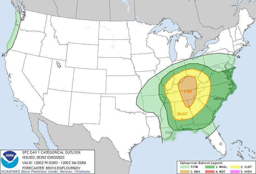
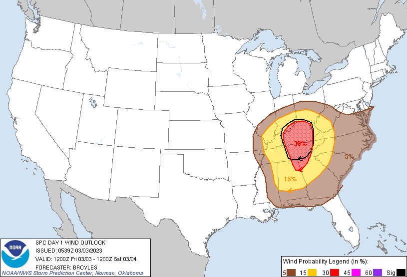
On Friday, March 3rd, the Storm Prediction Center placed most of the Louisville/Bowling Green area under an “enhanced” risk for severe weather, including a hatched area of increased significant damaging wind potential.
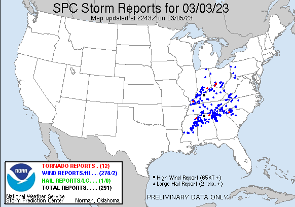
This resulted in severe weather across the region, highlighted by the storm reports below. There were mainly reports of damaging winds, but also isolated tornado reports.
3/3 Storm Reports- SPC
This was being driven by a strong, negatively-tilted upper-level trough moving through the area. In fact, “This intense storm broke all-time low pressure records at Louisville and Bowling Green. The lowest pressure observed in Louisville was 28.85″ around 3:14 pm EST (the old record was 28.93″ on February 28, 1902; records go back to 1893). The lowest pressure observed in Bowling Green was 28.96″ at 1:12pm CST (the old record was 29.04″, records go back to 1973).”- NWS Louisville.
This strong system not only spawned severe weather, but thanks to the low pressure, created intense non-thunderstorm wind gusts. Winds gusted between 60-80mph on Friday and caused widespread power outages and damage such as fallen tree limbs and structural damage. These were some of the most widespread damaging winds the region has seen since the remnants of Hurricane Ike passed through in 2008. Here is a map courtesy of NWS Louisville showing some of those wind gusts:
3/3 MaxWind Analysis- NWS Louisville
This storm system punctuates what has been a rather windy start to the year for Bowling Green, as 18 days since February 1st have boasted a wind gust above 20mph (KY Mesonet). This does not look to change as there are several chances this week for wind gusts of this level, but nothing close to the severity of Friday’s winds.
Hold on to your hats everyone! Have a great week 🙂
Posted inKentucky Weather|Comments Off on Flashback to Friday 3/3
Happy Wednesday and happy first Meteorological day of Spring! As we go into the month of spring, the season of storms, WKU will participate in the statewide tornado safety drill. At 9:07 am, WKU will test its emergency communications network, including the outdoor warning speakers. Today will be mostly sunny throughout the day, with a high near 78. As we go into this evening expect a chance for some showers and thunderstorms. Thursday will be mostly cloudy with a chance for scattered showers after noon and a high near 67. As we go into Thursday night expect more showers and some possible chances of thunderstorms.
Recent Wild Weather
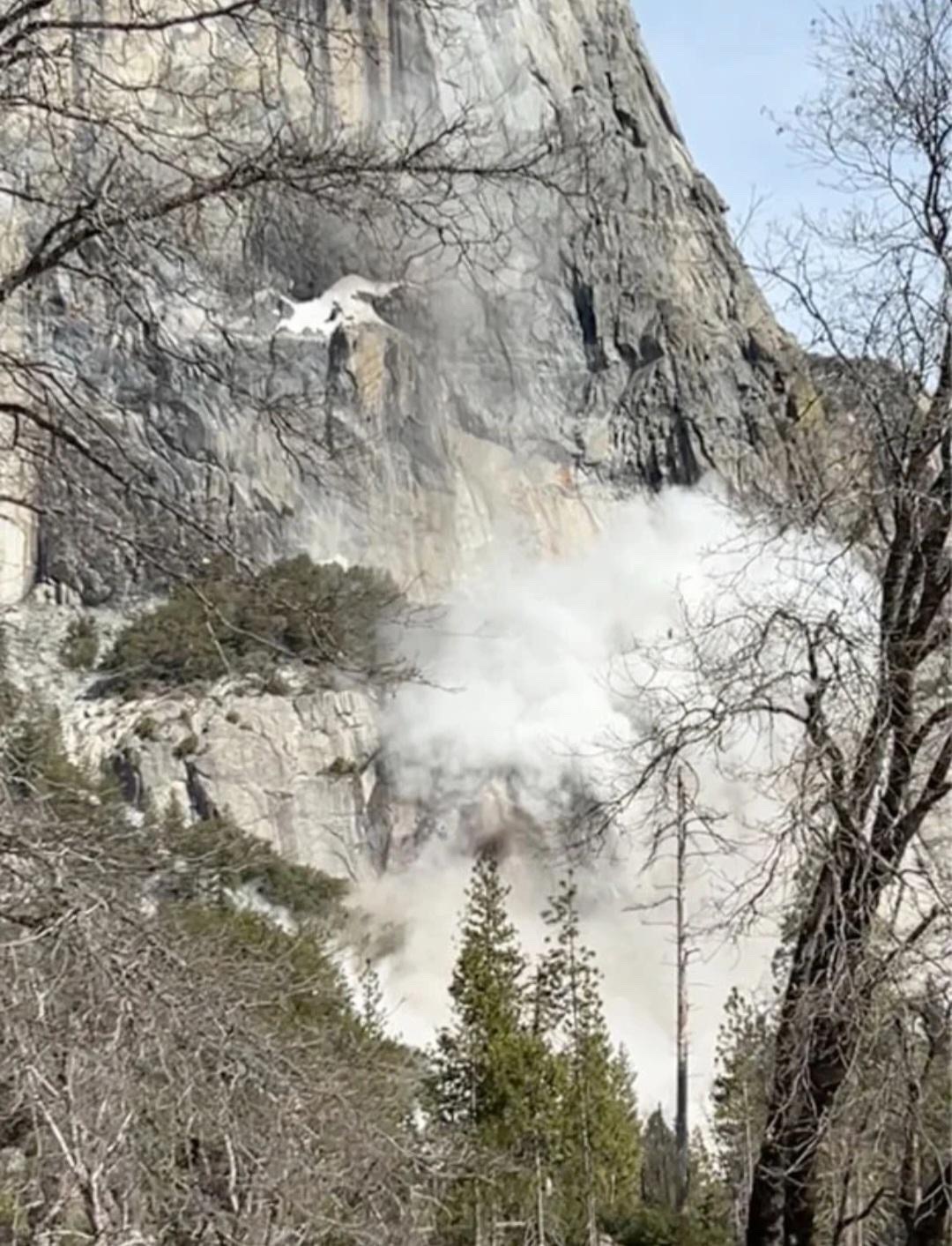
Remember a few weeks ago when I introduced you to Horsetail Fall in Yosemite? Well, this past week visitors were interrupted by a massive rockslide near Horsetail Fall. While rockslides aren’t uncommon in this location, they usually aren’t this large or this loud. The rockslide lasted for around 20 seconds in total and it was stated that even the people in the valley heard the rumbling of the boulders falling from the 3,000 ft high El Capitan rock formation. Footage was captured by artist and sculptor Alex J. Wood, who told that the noise from the fall was “thunderous”. Rockslides are caused when rainstorms, erosion, earthquakes, fires, etc. cause the soil and dirt to break up, causing the Earth to slide down. Rockslides can be catastrophic, but luckily, no one was hurt and after 24 hours all roads and trails have been safely reopened. The rockslide did not affect the firefall’s glow and you can still make the trip to Yosemite to see this wonderful phenomenon.
Wild Weather this Day in History
On March 1, 2007 a deadly EF-4 tornado struck Enterprise, AL. This tornado caused 9 fatalities and is the only EF-4 or stronger tornado to hit the NWS Tallahassee County warning area. This tornado was only one of many different tornadoes that went through the south that day. Beginning midday Thursday, March 1 through early morning Friday, March 2, the NWS office in Tallahassee issues 57 warnings (35 tornado, 19 severe thunderstorm, 4 special marine). Two of these tornadoes turned out deadly, for a total of 15 lives lost.
Have an amazing rest of the week and remember to stay weather aware as the season for severe storms amps up!
For today, you can expect some cooler conditions than we have had the past couple of days. Highs will peak around 50 degrees, and there will be mostly cloudy skies. For tonight, clouds increase as rain chances build overnight, and temperatures will be in the mid 40s. A bit of a downgrade from the weather the past couple days for sure!
What to Watch For
This weekend is going to feature plenty of rain chances, starting tonight and persisting through Monday. This rain does not present any serious flooding risk, however some areas are still saturated from the last soaking rains. Highs on Saturday will be mild in the mid 50s, while highs for your Sunday look to be in the low 60s. Early next week we look to dry out and see peeks of sun as temperatures rise by mid week.
Weather Fact!
Everyone knows not to eat the yellow snow, but have you ever heard of brown snow? On this day in 1936, brown-colored snow fell across New Hampshire and Vermont, and brown rain was reported in New York. Experts at the time claimed that the brown color came from dust storms in the Great Plains. (NWS)
Luckily no brown snow here! Have a great weekend everyone 🙂
Good morning, and happy Wednesday! As we go into today, we will be nearing record high temps! Clouds will increase throughout the day with a high near 80. A wind advisory will go into effect at 10am and last until midnight. Winds of 20-25 mph along with gusts of over 40 mph are expected. As we go into the evening expect showers and some isolated storms. A hazardous weather outlook has also been issued by the National Weather Service, as some of these storms could be strong to severe. As we go into Thursday, rain and storms will leave the area leaving us with a sunny, breezy, and hot day. A high of 81 and gusts of up to 26 mph are expected. Thursday night will be mostly cloudy with a low of 38.
Recent Wild Weather
During last Wednesday’s severe weather outbreak, upward lightning was captured near Memphis, Tennessee. In a video posted by the Weather Channel, you could see the lightning crawl upwards towards the sky, instead of coming out of the cloud downwards like normal. Some studies believe that upward lightning starts at the top of tall objects and then moves upward into a storm cloud. During a study on upward lightning, Tom Warner and his colleagues have captured 776 naturally occurring lightning flashes, 41 of them being upward lightning. They found that upward lightning usually occurs when there is a nearby positive cloud-to-ground flash. This electric field change causes an upward positive leader to initiate from a tall object or building. The shape of the tall object or building and enhancement in the electrical field make this upward lightning bolt form.
Women in Weather Making History
“The National Weather Service has issued thunderstorm and tornado watches for decades, but one had never been sent by a woman, until Wednesday.” As last Wednesday’s severe weather outbreak caused crazy, upwards lightning, it was also a day of firsts. Elizabeth Leitman has worked at the Norman, Oklahoma NWS center since 2010. She is one of only two women among the 22 full-time forecasters at the Storm Prediction Center, and has only ever known of 5 other women who have worked in the same center. By 1pm., Leitman knew conditions were becoming favorable for severe storms and after looking at radar, satellite, and observational data and talking to colleagues, she wrote up her first draft of the watch. For 2 hours she watched the size and scope of the storm, led a conference call with other offices responsible for counties within the watch area, and then told a colleague to “take a picture. It’s my first watch.” and hit send, issuing the watch. It was posted 15 minutes before the end of her shift and she followed it with a tweet stating that she was the first woman to issue a watch.
Have an amazing rest of the week and finally enjoy some warm temperatures!
Happy President’s Day! I hope you are enjoying this week of warm weather! And for some, a three-day weekend! Let’s take a look at the warm and sunny week ahead.
Monday Night: A low of 42 degrees with partly cloudy skies.
Tuesday: Partly cloudy skies with a high of around 64 degrees.
Tuesday Night: Cloudy with a passing rain shower and with a low of 55 degrees.
Wednesday: Cloudy skies with a very high of 76 degrees.
Enjoy this warm weather! Spring is still exactly a month away and it already feels like it! Also, if you have a pollen allergy, keep an eye on the tree pollen its levels are increasing.
Posted inKentucky Weather|Comments Off on Happy President’s Day!
After a rather warm week, today is going to be quite a shock to the system. Today you can expect much cooler temperature with highs in the upper 30s and lows tonight in the low 20s. At least today will be drier than yesterday!
What to Watch For
For your weekend you can expect a rebound in temperatures. Saturday will be cloudy, but temperature will rise into the lower 50s. Overnight, temperature cool into the mid 30s with clearing skies. For Sunday, highs will push 60 and skies will be clear. Enjoy the improved weather this weekend! Looking ahead to next week, temperatures will warm back into the 70s by mid week, but it comes at the expense of increased rain chances.
Weather Fact!
Yesterday here in Bowling Green was a soaker! Yesterday’s 24-hour rain total of 1.95″ was the most so far this year, and the greatest total since August 28th, 2022 when we saw 2.04″ of rain. (KY Mesonet)
Good morning, and happy Wednesday! I hope everyone is having a great week so far and getting prepared for some possible severe weather. As the wind advisory expired early this morning, that is not the last we will see of the wind, rain, and storms. Today will be unseasonably warm with a high of 76 and a low of 62. We can expect a breezy and mostly cloudy day with some sun shining through occasionally. As we go into late Wednesday night/early morning Thursday, we can see some showers and thunderstorms start to pick up. These storms will continue throughout the day until sometime Thursday afternoon. A few storms may be strong to severe with chances of heavy rain, gusty winds, and even some chances for hail. A first alert weather day has been declared for Thursday. Temperatures start out warm, but as the storm passes through temperatures will drop to the lower 40s and 30s.
Recent Wild Weather
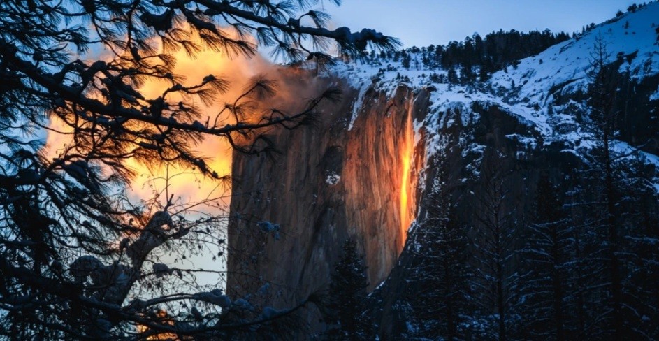
This week begins peak season for Yosemite National Park’s famous firefall to be seen in all its glory. Each year from mid to late February Horsetail Fall, sitting at 1,575 feet in the Yosemite Valley, takes on the look of a fiery waterfall. What causes this phenomenon you may ask? When the setting sun hits the waterfall at just the right angle, it gives the illusion that the waterfall is on fire. However, this isn’t the only condition that has to be met in order for this to occur. The weather must be in full cooperation. In addition to the sun’s angle being perfect, you will also need the sky to be absolutely clear to make way for the sun to come in and hit the water. You will also need a significant amount of precipitation to give the waterfall good flow. Luckily, 2023 has brought record breaking amounts of snow and rain to California. It’s the perfect setup to get this “firefall” glowing! It has become such a popular event for nature lovers and photographers that reservations are now being required. This year’s peak dates for viewing this phenomenon are February 10th-27th with a viewing time between 5:00 p.m. and 6:00 p.m. as the sun is setting. Park temperatures this time of the year in Yosemite average between 28°-53°.
Wild Weather this Day in History
Well, snow, snow, and more snow! So, instead I’d like to take this moment to recognize one of the greatest astronomers, physicist, and engineers to ever live! Galileo di Vincenzo Bonaiuti de’ Galilei (commonly referred to, simply as, Galileo) was born on this day in history, February 15th, 1564. Galileo was an Italian mastermind, responsible for many discoveries and inventions that helped propel the scientific world forward. Among the many inventions he is responsible for, he invented the thermoscope, now the modern thermometer. Galileo’s original design was a device that could show changes in temperature in a liquid-filled tube. The different liquids rise and fall as the temperature changes. These thermoscopes have once again become popular, and you may have seen on and didn’t even realize it. Happy birthday Galileo!
Have an amazing rest of the week, and make sure to stay up to date with your latest weather conditions!
Happy Monday and happy Valentine’s Day! I hope you remembered a gift for that special someone, and for everyone else, we get a gift of warmer temperatures! This also might be a good time to go watch, “Forecasting Love and Weather” on Netflix. I hear good things about it but I haven’t gotten around to watching it yet. Now on to the forecast.
A Wind Advisory is in effect from 7pm Tuesday until 7am Wednesday for wind gusts up to 50mph possible.
Monday Night: A low of 37 degrees with partly cloudy skies.
Tuesday: A cloudy day with a high of around 66 degrees. Winds are 10-20mph with gusts up to 40mph, so bring in those small items.
Tuesday Night: The wind does not die down during the night. Scattered rain showers in the evening before becoming partly cloudy overnight.