This is a long forecast given i will be in New Orleans from Saturday through Wednesday for the AMS conference. This means I will not be able to update any severe warnings Sunday Night/Monday. I may ask someone else to cover as well.
Here is a link to the AMS conference http://annual.ametsoc.org/2012/
Locally there will be a weather conference in February @ the Holiday Inn in Bowling Green. I hope to meet some of you there. A great chance to learn all about weather and meet meteorologists in the region!
http://kyem.ky.gov/Pages/default.aspx
Let’s get to the weather
1. A major bust by almost all meteorologists out there, even had to slap myself silly after missing this one. It only takes a small amount of instability with lots of shear to make a situation very threatening. Should have been watching the soundings closer. No watches were issued by the SPC this has happened many times in recent months including my time at NWS-PHL. Severe reports keep coming in and no watch is issued. UMM…..
2. Friday will see a boundary over our region which will lead to dramatically different temps across the state. Lows will be near 30 south. Highs Friday in the south may make the low 50′s with Southwest winds increasing from 10-20 MPH. A low pressure system will track across the region Friday night bringing moisture with it interacting with the boundary and producing light rain known as isentropic lift. Friday night temperatures should rise into the low and mid 50′s. Some elevated thunder is possible as well but any instability should stay south of the region.
3. Temperatures Saturday should be in the 40’s as we clear out.
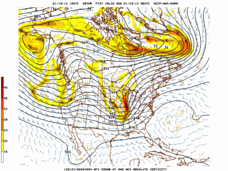
4. Sunday another surge of Warm air advection WAA will bring much warmer weather and south to southwest winds at 20-30 mph. lows will start out in the 30′s maybe low 40′s with highs in the 60′s. Sunday night a strong cold front should move through with rising temps once again at night. The overall trough will be negative tilted, a strong LLJ will also be present. A impressive vort max should be moving just to the west of the region as well.
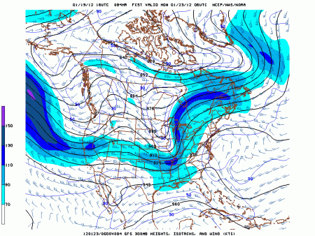
A look at the 300 mb jet notice a nice piece of jet energy moving in
A look at the soundings shows the LLJ to be impressive from 60-80 KTS, helicity values should be the roof again a key indicator of updrafts needed for storm rotation. Sufficient instabilty appears to be present at this time for another severe weather event either Sunday night or Monday morning.
A squall line of thunderstorms should bring widespread severe weather sometime Sunday night or Monday morning with the frontal passage. High public impact. I strongly disagree with the SPC that this is a non event. That type of talk last time lead to a very bad forecast day there Tuesday. Apologies for not being able to post warnings in advance due to my absence.
5. Monday should clear out a bit lows will be in the 30′s with highs in the 40′s. Tuesday and Wednesday I’m keeping dry with highs in the 40′s maybe low 50′s and lows in the 30′s to maybe around 40.
Last week the long range euro showed promise of colder times for the first half of Feb, this week’s run has been replaced by record warmth and lots of it.


low level cold has kept short of the low 50’s today. expect steady temps most of the night then falling into the 30’s late tonight.