Days at a Glance:
Tonight: Showers and lingering clouds will dissipate into the evening and overnight hours with winds from the SE at 5-6 mph. Only trace accumulations are expected.
Monday: Begin the day with a low of 68. Skies will continue to clear into the morning and afternoon with southerly winds at 5-6 mph. It will be rather steamy with a high of 92. Popup showers due to increasing instability are 10% likely into the latter half of the afternoon with likelihood decreasing by nightfall. Associated showers will be relatively brief and localized with accumulations under .10 of an inch.
Tuesday: Start the day with a low of 70. Clear skies will dominate throughout the day with SSW winds at 11-12 mph. More of the same sticky heat with a high of 93. There is a 20% chance of popup showers likely in the later afternoon hours until nightfall. Associate showers will be relatively brief and localized in nature with accumulations under .15 of an inch.
Wednesday: Begin with a low of 71. Clouds will begin to increase throughout the day, especially into the afternoon hours. Winds will be SW at 5-7 mph with temperatures reaching 92. A 25% chance of popup showers remains as with Monday and Tuesday, but the chance for widespread showers will also increase into the evening and overnight hours.
Discussion:
Increasing clouds since this morning has produced overcast conditions and disrupted our streak of sunny days. Only a marginal chance of precipitation accumulation will persist into the evening and overnight hours as clouds begin to dissipate. The sun will reemerge tomorrow as will this sticky heat that will persist into the middle of the work week. Temperatures will reach the low to mid 90’s Monday through Wednesday with dew points in the upper 60’s. This will make for a unpleasant couple of days, but do enjoy the sunshine. If outside, remember to drink plenty of fluids, especially if performing strenuous activities.
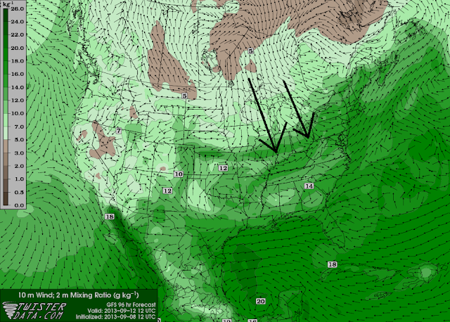
But transition is in the air as a cold front will begin to slide through our area overnight Wednesday into Thursday. Models are having difficulty agreeing to the exact timing, strength, and expected rainfall accumulation of this cold front. A better picture can be made closer to Wednesday but the setup is not looking overly impressive.
Widespread showers with embedded thunderstorms is possible with severe weather not expected. What can be assumed is a nice relief from the humidity into the final days of the work week and weekend.
Next Forecast: Wednesday
Forecaster: Austin Boys

