
My last post at the beginning of the month discussed the possibility of mid-November cold with the caveat that “the EPO is not supportive of an extended cold air outbreak”. This turned out to be exactly true as the EPO has been strongly positive for the last few days, which teleconnects to a strong, zonal Pacific jet which in turn floods the U.S. with mild, Pacific air and frequent but weak storms. So despite a weakly negative NAO (which is often a cool signal), the Mid-South has enjoyed balmy near 70 degree weather the past couple of days despite widespread cloudiness. Things are about to change just in time for the Thanksgiving holiday!
Here are the clues to the cold end of month forecast…
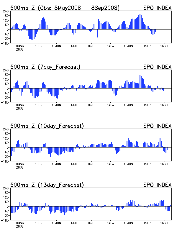
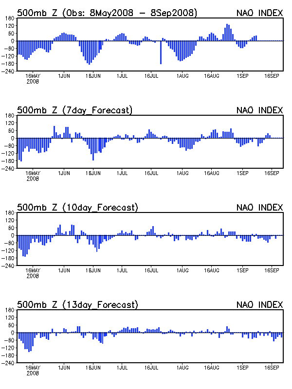
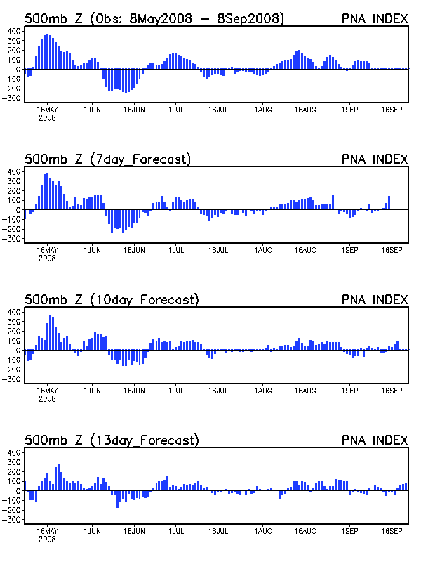
1) Three atmospheric teleconnections strongly influence winter weather in the Mid-South. The East Pacific Oscillation (EPO), North Atlantic Oscillation (NAO) and the Pacific/North American Oscillation (PNA). Cold signals for the Mid-South are a negative EPO and NAO and a positive PNA while warm signals occur during the opposite phases. Strong and prolonged cold-air outbreaks (think February 2007) occur when all three oscillations display a strong cold signal and weak and/or brief cold-air outbreaks (early November 2007) occur when only one or two display a cold signal and the others are warm. In my opinion, the most important teleconnection to the Mid-South is the EPO, since that oscillation controls the jet stream to our west, which then influences the type of air mass that can reach our area. A good forecasting rule of thumb is that when the EPO and NAO are both strongly negative, a prolonged arctic outbreak is sure to follow. To read the teleconnection graphs, keep in mind that the top graph is the actual real-time observation while the bottom three graphs are the 7-, 10-, and 13-day forecasts of the oscillations. Therefore, it is possible to predict the direction of the oscillation about two weeks in advance, since the oscillations usually lead the actual cold-air outbreaks by a couple of days. Looking at EPO, NAO, and PNA forecasts, you can see that the EPO, NAO, and PNA are all forecast to be in their respective cold phases after about November 20. The caveat here is that none of the teleconnections are strongly anomalous and that the long-range teleconnection forecasts have not verified well recently.
2) Once you know the likely direction of the teleconnections, you can look to see if the operational models support the teleconnections in the mid-range forecasts (8-14 days). The key to switch from the currently zonal pattern into a more interesting meridional pattern will be if one of the many shortwaves in the zonal flow can become negatively tilted and lower heights over the eastern United States. For example, on the 132-hr maps from the 12z GFS, a strong jet on the left side of a weak trough axis over the Great Plains will cause that trough to deepen sharply by 180-hrs. This trough then supports a number of very cold, arctic air masses to plunge into the eastern United States during the last 10 days of November with at least one decent snowstorm for the northern plains, Great Lakes region. Once again, past about seven days, you can’t take any particular model run of any model as reality, but you can look for trends.
3) Once you have teleconnection and GFS support, you can then look to inter- and intra-model comparisons. The European model (ECMWF) is in pretty good agreement with the GFS over the 8-10 day period but there is still some wide disagreement among the GFS ensembles at 192 hrs and beyond, although the GFS ensembles have had the unusual trait of being more similar at Day 10 than Day 7 recently.
Bottom Line: There is an increasing likelihood of below normal temperatures for the last 10 days of November. Whether it will be a brief (3-5 day) cold air outbreak or a prolonged (7-14 day) outbreak is still to be seen. It is also too early to determine if there will be any frozen precipitation in the Mid-South, although the first snowstorm of the season is likely with this pattern for the northern Plains/Great Lakes.