
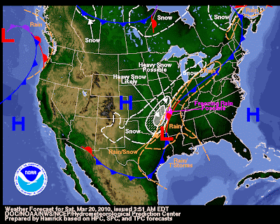
Trough continues to dig across the central US, which will eventually lead to a closed low pressure system. The upper-level low will push into Mississippi by tomorrow, with the surface low located to the north of this. With the conditions given, showers should start late tonight, with showers and storms passing through tomorrow morning. Cold front associated with this will track through later in the day Sunday, presenting warmer temperatures than first expected. Below is the current weather for the USA, you can view the low pressure system that will effect us passing along the AR/LA border (Don’t worry, we will NOT be receiving any snow):
For today, expect another beautiful one, with highs tapping into the 70’s. Clouds will increase into tonight, with the approaching system nearing its time of arrival. A series of showers and storms will pass ahead of the cold front boundary, allowing for high temperatures tomorrow to hit around 60 degrees before the boundary passes. By tomorrow night, expect a chilly low of 38 degrees with more showers expected. Be sure and enjoy today, for tomorrow looks to bring more of the gloomy weather.