
The same storm that dumped snow over the southern plains this weekend is now effecting our area. The low pressure system is currently located over western Tennessee and is bringing us a cold and gloomy Monday. The low pressure center is associated with a trough that is swinging through the southern US. The trough has brought in another shot of cold air that is bringing in well below normal High temperatures across the entire southern US.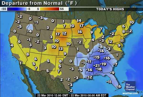
The above map is showing the departure from normal expected high temperatures for this time of year. Today in Bowling Green we can expect a high of 44 and a slight chance of showers later this evening into the overnight hours as this system continues to push through the area. Overnight the low temperatures should only dip down into the upper 30’s due to the cloud cover that will remain with us. Tomorrow should be a much nicer day as the trough exits our area. The exiting trough will cause a quick rebound in temperatures closer to what we have seen over the last week. The cloud cover should also be clearing tomorrow as the day progresses allowing for temperatures to reach near 66. Tomorrow night’s low should be around 43. Wednesday is looking to be very nice as well, but we do have a chance for some more rain later in the week. Come back Wednesday to get the full update. As always thanks for checking WKU’s met blog and have a wonderful day!