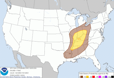
Moving into the weekend, we will see a strong shortwave trough continue to advance east over our area. This disturbance will have weakened somewhat upon arrival but will still allow for the development of severe weather across Western Kentucky.
The lacking factor in this set up will be instability. CAPE parameters are lacking looking through the day Sunday with values less than 750 j/kg^1. This is likely due to forecast overcast skies Sunday that will inhibit any daytime heating and air mass destabilization. With this in mind, we are looking at a linear squall line even for Western Kentucky with the biggest threats being damaging winds and hail though an isolated squall line tornado is not out of the question. The Storm Prediction Center has placed Bowling Green in the slight risk for Sunday. Taking a look at the probabilistic outlook, we see Bowling Green in a 15% chance for severe storms Sunday.
A strengthening pressure gradient out ahead of the system will contribute to a strong low level jet and gusty Sunday. A high wind advisory may need to be issued into the day Sunday. Temperatures will take a dip after the passage of the cold front Sunday night with surface ridging building in behind.
Sunday Forecast Overview:
High, 75. Low, 56. Gusty winds throughout the day with thunderstorm development in the late afternoon. Main threats high wind and hail. Storm to continue into the night with rain ending in the early hours Monday morning.


