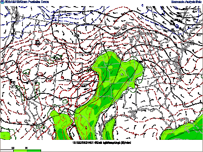
Current conditions have Bowling Green under the dominance of a surface high pressure system. As Chris stated in the previous forecast, it will linger around through the middle of the week. There is an upper level ridge situated over the central US preventing the influence of any disturbances into our area. This looks to change into Thursday as the ridge begins to break down. The surface high pressure is then depicted by both the NAM and GFS to progress eastward.
Our start to the week is not a complete snooze. The picture above shows the strong moisture axis stretching from the Texas Gulf coast into eastern Oklahoma northeastward into Missouri, Iowa, and Illinois. This inflow of warming temperatures and higher moisture values looks to continue across that area into the middle of the week. This is significant because there is a low pressure system shown to develop along a stalled cold front boundary in the Great Plains. Models depict the associated warm front to extend across the lower Great Lakes eastward starting tomorrow into Wednesday. The low pressure system is not shown to progress eastward but to the north since our area will be shielded by the persistent dome of high pressure, leaving us with little chance of rain.
With this said, expect a dry and beautiful start to the week. Temperatures will stay consistent with today with a slight warming trend. Highs in the upper 70’s and lower 80’s and lows in the lower 50’s. Get outdoors and enjoy the weather, or lack thereof.
Forecaster: Austin Boys

