It has been a warm start to October with highs reaching into the 80’s for the first day of the month. According to a monthly summary from the Kentucky Mesonet for October 2012, the high temperature for October 1, 2012 was 66.4 F at the station located at the Western Kentucky agricultural farm. The following week, however, showed a climb back into the upper 70’s before a drop back into the 60’s with lows in the mid 30’s. This shows that though we are unseasonably warm, we are not far off from the October temperatures of last year.
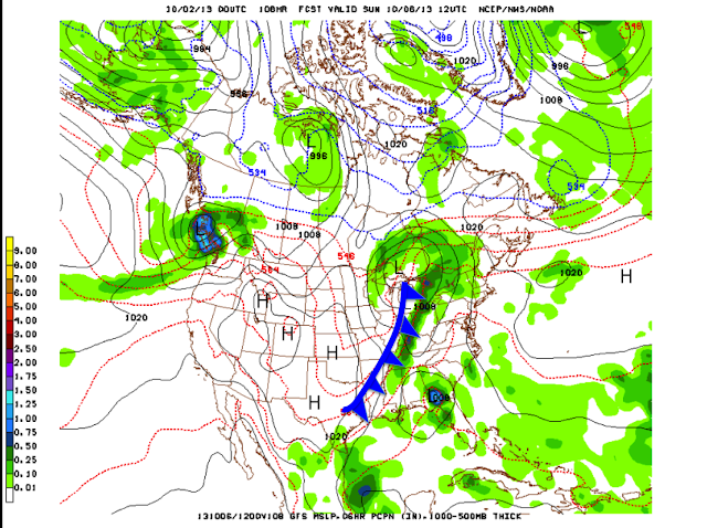
As of now, a ridge of high pressure is dominating weather over the Commonwealth bringing in the oppressive October heat. A chance for precipitation exists Wednesday as an upper level low becomes a broad low pressure wave and moves over Kentucky. Any showers that develop will likely be in the morning hours and isolated in nature. A pattern shift will occur into the weekend when we will see a stronger system move in bringing a trough swinging through the eastern US and bringing the polar jet and cooler drier air behind a significant cold frontal boundary set to march across the eastern United States into Saturday. This cool down will provide us temperatures more favored to the mid-60’s with lows in the mid-40’s by Sunday after the front passes through.
 |
| NAM Surface Temperature and Winds Valid 12 z (7 am CDT) Saturday, October 5th. |
With this system, we will also expect some rain/thunderstorm chances Saturday and Sunday as the front approaches. The highest chance for precipitation looks to be Saturday night as the models bring the frontal boundary through western/central Kentucky. With the surface low displaced to our northeast, the severe threat will be significantly higher to the northeast across Illinois, Indiana, and Ohio and diminished for us in south-central Kentucky. This will not rule out some locally strong storms with ample moisture and moderate pockets of instability depending on the frontal passage timing and thunderstorm development period. A further update on the severe weather potential will be given on Friday.
 |
| GFS Mean Sea Level Pressure and Precipitation valid 12 z (7 am CDT) for Sunday, October 6th. |
Daily Forecasts:
Wednesday: High, 80. Partly cloudy with winds calm to 5 mph. Slight chance for isolated rain/thunderstorms around 30%.
Wednesday Night: Low, 69. Cloudy with light winds. Slight chance of precipitation around 20%.
Thursday: High, 81. Mostly sunny with light winds from 5-10 mph.
Thursday Night: Low, 68. Cloudy with light winds.
Friday: High, 83. Sunny with few clouds.
Friday Night: Low, 70. Cloudy.
Saturday: High, 82. Chance of precipitation increasing into the day. Some locally strong storms possible.
Saturday Night: Low, 62. Chance of precipitation increasing into the night with a cool off after frontal passage.
Forecaster: Emily Thortnon
Next Update: Friday, October 4th.
