Today in Weather History

Good morning to you, fellow reader!

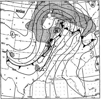
On this day, in 1950, a low pressure system propagated over eastern Illinois, allowing for the rare event of a tornado-producing storm system in the month of December. The atmospheric set-up can be seen in the photo below. Illinois saw two tornadoes while Arkansas saw one tornado. Missouri, on the other hand, fell victim to a significant hail storm.

(National Weather Service)

That’s all for today! If you’re a student, good luck on finals next week! If not, we hope you still have a good week!

Posted in Kentucky Weather | Comments Off on Today in Weather History

Today in Weather History

Good evening! We hope you are doing well!

On this day, in 2000, parts of northern South Dakota and western Minnesota saw a snowstorm that produced six to twelve inches of snow. This created complications with transportation, as several accidents occurred, and cancellations of events and schools. Below is a table that shows snowfall totals for various areas across the region impacted.

LocationSnowfall (Inches)
Milbank, Ortonville6.0
McLaughlin, Ipswich, Summit, Mellette8.0
Britton, Clear Lake, Pollock9.0
Leola, Faulkton10.0
Aberdeen, Webster11.0
Houghton12.0
(National Weather Service)

That’s all for today! Have a good day!

Posted in Kentucky Weather | Comments Off on Today in Weather History

Today in Weather History

Good evening to you!

On this day, in 1996, heavy snowfall piles onto northern South Dakota, to which added to already significant snow depth from a previous snowstorm. This snowstorm produced six to eight inches of snow across the area, paralyzing travel and cancelling events. Below is a table that shows snowfall totals across the area impacted.

LocationSnowfall (Inches)
Aberdeen, Isabel, Roscoe, Mellette6.0
Eagle Butte, Timber Lake, Selby, Faulkton, Leola, Frederick, Webster, Sisseton7.0
Britton, Ipswich, Eureka, McLaughlin8.0
(National Weather Service)

That’s all for today! Thanksgiving is coming up, we hope you have a great holiday!

Posted in Kentucky Weather | Comments Off on Today in Weather History

Drier Monday, Thanksgiving Preview

Good morning and happy Monday, folks!

Forecast

Yesterday’s soaker brought us .86″ of rain here in the Bowling Green area, the highest daily rainfall total so far this month (Kentucky Mesonet). Today, we’ll get the chance to dry out a bit. Temperatures are going to be cool, with highs in the low 40’s, and partly cloudy skies. With drier air and clearer skies comes a substantial shot of cold air tonight, as temperatures will plummet into the lower 20’s. Brr!

We are keeping an eye on your Turkey Day Forecast as well- stay tuned for some potential rain.

Weather Fact! (Thankful Edition)

Let’s review some past weather records for Thanksgiving Day here in Bowling Green! In 1896, the Bowling Green area saw a high of 75 degrees, making it the highest max temperature ever recorded on Thanksgiving. On two separate occasions, in 1912 and 1950, the low temperature was a mere 15 degrees. (NWS Louisville)

I’ll leave you all with a bit of a teaser: Thanksgiving night this year looks like it may not be too far off from that record low temperature!

Have a great week everyone!

Posted in Kentucky Weather | Comments Off on Drier Monday, Thanksgiving Preview

Today in Weather History

Good afternoon, everyone!

On this day, in 1992, parts of northeast South Dakota and west central Minnesota saw a snowstorm that produced three to eleven inches of snow. Below is a table that shows snowfall totals across the area of interest.

LocationSnowfall (Inches)
Browns Valley (SD)11.0
Sisseton (MN)9.0
Victor (SD)8.0
Artichoke Lake (MN)7.9
Clear Lake (SD)7.0
(National Weather Service)

That’ll do for today! Have a wonderful weekend!

Posted in Kentucky Weather | Comments Off on Today in Weather History

Today in Weather History

Good evening, fellow readers!

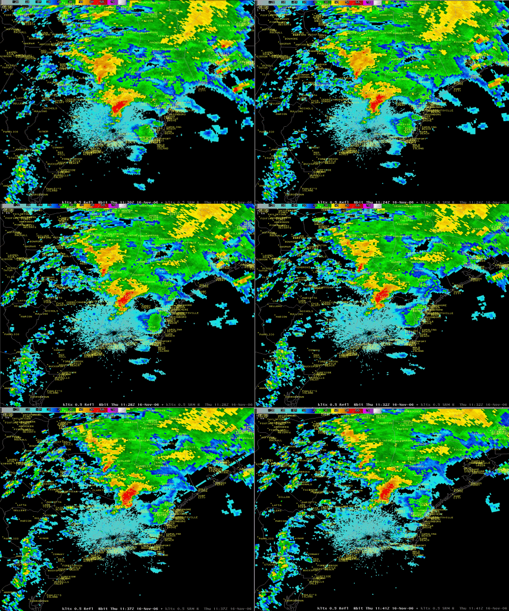
On this day, in 2006, an early morning tornado tore through southeastern counties of North Carolina. This tornado was ranked a three on the Fujita Scale, to which correlates with severe damage and winds in the range of 158 to 206 miles per hour. Its path was a mile long, leaving a few dozen trees (12-18 inch diameter) snapped, a tractor flipped, and several trailer homes lifted from their foundation and broken apart. A total of twenty people were injured and eight were killed. Below is a base reflectivity loop of this storm.

(National Weather Service)

That’s all for today! Have a good one!

Posted in Kentucky Weather | Comments Off on Today in Weather History

Monday Forecast

Good morning, and happy Monday, readers!

Forecast

Today, you can expect a continuation of the chilly November air for our region. High temperatures will be in the lower 50’s, with a mix of clouds and sun. Tonight, expect some clearing, with low temperatures in the upper 30s. Definitely a good day to pull out your favorite sweater! If you are not a fan of the cool weather, you will be excited to hear that temperatures are forecast to warm up a bit for us the next couple of days. So stay tuned to see just how warm we will get!

Weather Fact!

On this day in 1900 in Watertown, NY, 45″ of snow (Yes! You read that right!) fell in just 24 hours as a result of a lake effect snowstorm. (NWS)

Always exciting to dream about that much snow 🙂 have a great day everyone!

Posted in Kentucky Weather | Comments Off on Monday Forecast

Today in Weather History

Good evening to you!

On this day, in 2000, parts of northeast South Dakota and west-central Minnesota fell victim to a snowstorm that produced a range of 6 to 14 inches of snowfall. This caused for complications on the roads, with many vehicles ending up stuck in the snowpack or off-road in ditches. Below is a table that shows different precipitation totals that were recorded across the area impacted.

LocationSnowfall Total (Inches)
Miller14.0
Mellette13.8
Highmore12.5
Iona11.5
Wilmot11.0
Aberdeen10.0
Clark9.5
Clear Lake9.0
(National Weather Service)

That’s all for today! Have a great rest of the week!

Posted in Kentucky Weather | Comments Off on Today in Weather History

Beautiful November Wednesday

Hello readers, and happy Wednesday!

Forecast

After last week’s freeze, we are definitely thawing out a bit this week. Yesterday was a wonderful day, and today with be just the same. Expect mostly sunny skies, with high temperatures in the low 70s. After the pleasant day, some clouds build in overnight as rain chances enter the picture tomorrow. Tonight’s low temperatures will be in the mid 50s. Make sure and stay tuned for the rain potential tomorrow!

Weather Fact!

On this date in 2002, “the town of Mossy Grove, TN was “wiped off the map” by a destructive tornado that killed 7 people.” (NWS)

The National Weather Service using the term “wiped off the map” speaks to the destruction done to this small Tennessee town on this day 19 years ago. Fortunately nothing like that is occurring today, and hopefully never will.

Have a great rest of your week, everyone 🙂

Posted in Kentucky Weather | Comments Off on Beautiful November Wednesday

The Perfect Forecast

Good afternoon, fellow readers!

If you’re out and about early tomorrow, it may be wise to slip on a jacket, as temperatures will start out cooler in the lower 40’s. As the sun rises, temperatures will, too, with our high reaching the lower 70’s. Winds will remain calm with very few clouds in the sky. We highly recommend making plans to be outdoors, as this will be ideal Autumn weather. By nightfall, temperatures will bottom out in the lower 50’s. Bonfire, anyone? We think yes!

That’s all for today! Have a great week!

Posted in Kentucky Weather | Comments Off on The Perfect Forecast