Chilly Start to the Week!

Good morning folks, and happy Monday!

Forecast

Gone is the warmth for today, this week, and potentially the fall season. A large dome of high pressure has established itself over the majority of the eastern half of the continental United States. With this, you can expect calmer and cooler weather than we have been dealing with this past couple weeks. Today is no different, with sunny skies warming up into the comfortable low 70s, and overnight lows chilly once again, in the low 40s.
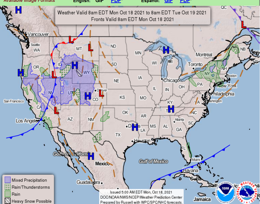
Photo courtesy of the NWS Weather Prediction Center

Weather Fact!

Up until this past weekend, we had exceeded the average high for the Month of October (71) every day of October here in Bowling Green. (US Climate Data and Kentucky Mesonet)

For those fans of the cooler weather, that pattern is indeed changing. Have a great week everyone 🙂

Posted in Kentucky Weather | Comments Off on Chilly Start to the Week!

Wonderful Wednesday!

Happy Wednesday, readers!

Forecast

Conditions out there for your day today will be warm, with highs in the low 80’s. Unlike our previous warm days, you can expect cloudy skies instead of sun. The warmth today will not feel as warm without the presence of abundant sunshine, so get out there and enjoy if you are not a fan of the warmer weather! Tonight, cloudy skies give way to partial clearing, as temperatures dip into the mid 60’s. We’ll keep our eyes on a storm chance for Friday, and a shot of much cooler air this weekend.

Weather Fact!

On this date in 2014, Bowling Green received over an inch and a half of rain. This rain was associated with the system that was responsible for an EF1 tornado in Clarksville, TN. (US Climate Data and NWS Nashville)

Have a great rest of your week, folks!

Posted in Kentucky Weather | Comments Off on Wonderful Wednesday!

Today in Weather History

Good morning, everyone!

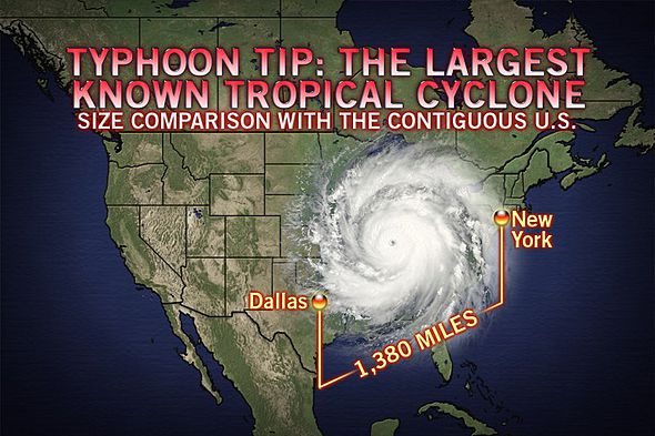
On this day, in 1979, the lowest barometric pressure in history was measured in the center of Typhoon Tip. This storm had a staggering low pressure of 870 hPa. Peak winds reached 190 miles per hour. A total of ninety-nine lives were lost. Not to mention, it was absolutely massive in size with a diameter of 1,380 miles. Check out the photo below for a perspective on just how big Tip was!

Check out this comparison!

That’s all for now! Have a great day!

Posted in Kentucky Weather | Comments Off on Today in Weather History

Marvelous Monday!

Hello readers, and happy Monday!

Forecast

The weather has been pleasant, yet warm. You can expect more of the same for today, with temperatures in the low 80’s and fair amounts of sun. Also for today, you can expect a bit of a blustery day, with winds of 15-20 mph. Overnight, there is a slight chance of showers locally, but most of the wet weather will stay off to the west where there is a marginal severe weather risk. Lows tonight in the mid 60’s.

Weather Fact!

On this day in 1846, The Great Key West Hurricane struck the island with a five-foot storm surge. Damage was extensive, and the hurricane destroyed two lighthouses. (NWS)

Get out there and enjoy the pleasant windy day! 🙂

Posted in Kentucky Weather | Comments Off on Marvelous Monday!

Goodbye, Gloom!

Greetings, readers! How is your week going so far? We hope fantastic! If not, this post will surely brighten your mood!

For the rest of the week, our region of the country will bask in high pressure, ridding of those pesky precipitation chances and that overbearing cloud cover. As we have an influx of sunshine, temperatures will be on the rise with temperatures peaking in the lower to mid 80’s for each remaining day of the week. Likewise, low’s will be in the lower 60’s. Our only concern for this period of time will be with early morning patchy fog, so if you plan to be out on the roads, be careful!

We hope you have a wonderful rest of the week!

Posted in Kentucky Weather | Comments Off on Goodbye, Gloom!

Storm Chance Today!

Happy Wednesday, readers!

Forecast

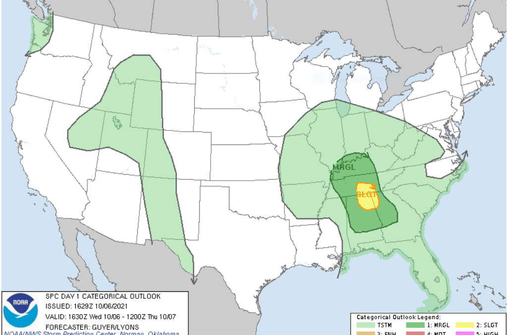
Today we have the potential for some wet, and even stormy weather. Most of the day will be pleasant and nice, with highs in the mid 70’s and some sunshine. Later this evening, we do have the chance for some storms.

The National Weather Service Storm Prediction Center has placed our area is a “Marginal” risk for severe storms. Keep an eye on the radar, and keep in mind this potential if you are planning outdoor activities or travel. Each of these storms will have the potential for small hail, gusty winds, and heavy rain. The storm chances decrease overnight, as mainly rain takes over, with lows in the low 60’s.

Be safe out there everyone, and have a great day!

Posted in Kentucky Weather | Comments Off on Storm Chance Today!

Potential for Excessive Rainfall Tomorrow

Good evening, everyone! We hope you are having a great week so far!

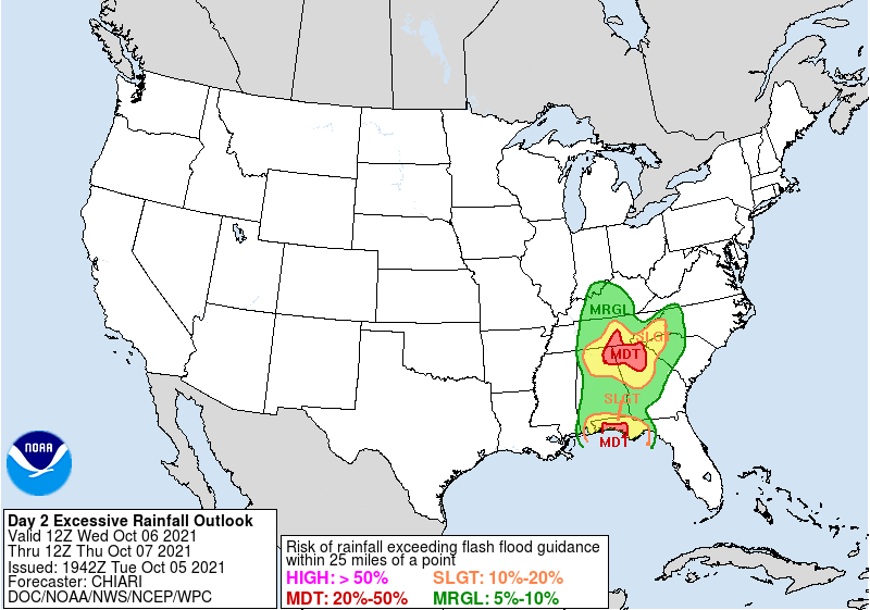
For tomorrow, chances of showers and storms will remain in the forecast as a low pressure system propagates slowly through the eastern region of the country. These will be scattered for the start of the day, but will become widespread into the evening. Our main threats will be lightning and heavy rainfall, that of which will pose a threat for localized flash flooding. As shown below, the Weather Prediction Center has our county under a marginal risk for excessive rainfall.

That’s all for today! Have a great rest of the night!

Posted in Kentucky Weather | Comments Off on Potential for Excessive Rainfall Tomorrow

Pleasant Monday

Good morning and happy Monday, readers!

Forecast

Monday is shaping up to be a nice day for us locally. We get a chance to dry out a bit from the rain this past weekend, and before the rain chances increase throughout this week. You can expect partly cloudy skies today, with temperatures in the upper 70’s. Tonight, we cool off into the upper 50’s as we prepare for storm chances tomorrow. Enjoy the nice day today!

Weather Fact!

Our average monthly rainfall in September here in Bowling Green is 3.93 inches (U.S. Climate Data). This past month we were above average, as we recorded 5.1 inches of rain (Kentucky Mesonet). That certainly reflects our rainy pattern!

Have a nice week everyone 🙂

Posted in Kentucky Weather | Comments Off on Pleasant Monday

Disturbance Brings About Precipitation Chances

Good evening, fellow readers!

As the weekend approaches, so does a disturbance to our west. For Friday, chances of showers and storms will remain isolated in the evening, but these chances will surge to become scattered as we move into the weekend. Thanks to the timing of the cold front, this will call for a rather split forecast, with Saturday having abundant sunshine and Sunday having overbearing cloud cover. From this, Saturday will have a high in the lower 80’s whilst Sunday will be a little cooler, with temperatures peaking in the upper 70’s. Nights will remain comfortable with temperatures lingering in the mid 60’s.

We hope you have a wonderful weekend!

Posted in Kentucky Weather | Comments Off on Disturbance Brings About Precipitation Chances

A Calm Week

Happy Wednesday folks!

Forecast

Quite the calm week weather wise, as temperatures have been warm, and the skies have been clear. You can expect more of the same for the rest of the week, with highs in the mid 80’s and lows in the lower 60’s. If you are a fan of the warmth, get out there and enjoy it!

Weather Fact!

If you think the weather is warm in our area today, try and remember what it felt like two years ago today. On this date in 2019, the temperature locally reached 94 degrees! That’s quite the heat for this late in the season! This date a year ago in 2020 was more my speed, with a high of 67 and a low of 47. (Farmer’s Almanac)

Hopefully the cooler weather finds us soon, I want to wear my flannel! Have a great rest of your week, everyone 🙂

Posted in Kentucky Weather | Comments Off on A Calm Week