Unseasonably warm temperatures to stick around….

As we start another week and head into the Thanksgiving holiday, conditions across the area are expected to be unseasonably warmer.  A fast zonal upper air flow continues across much of the eastern United States as the northern branch of the jet is located along the U.S./Canadian border, helping keep the cooler air to our north.  A weak 500 mb ridge will temporarily develop over the region today, followed by a weak trough that will slide through the Commonwealth by Monday.

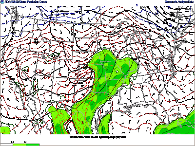
HPC/NOAA short range forecast valid for Tuesday 12Z. Ridge of high pressure will build over the Tennessee Valley region as the weak trough to our west tracks eastward through the area by Monday night/early Tuesday morning.

As the low tracks through late Monday night, a slight chance for an isolated shower will exist although the main threat seems to be cloud cover.  Neither feature will have much effect on the the overall temperatures as a gradual warm up is expected through the Thanksgiving holiday.  The HPC’s QPF maps below seems to show agreement as any rainfall that does occur will be light and mainly to the north of the state.

HPC’s QPF precipitation forecast map valid for Tuesday 12Z. Showing areas of light precip. just to the north of the state in parts of southern Illinois and Indiana.

Highs for your Sunday will begin a nice stretch of comfortable fall time weather.  Temperatures are expected to reach the low to mid 60’s here in Bowling Green under mostly sunny skies, as identical days look to follow.  Skies will remain clear for your Sunday evening as temperatures drop to around 36 degrees with calm winds expected.

—————————-

Monday: Expect mostly sunny skies. High: 64.

Monday night: Expect increasing clouds with light and variable winds from the west. Low: 43

Tuesday: Another nice day with partly sunny conditions. High:65 Light winds from the southwest around 5mph.

Tuesday night: Partly to mostly cloudy skies expected. Low: 41


Forecaster: Chris Johnson

Posted in Uncategorized | Comments Off on Unseasonably warm temperatures to stick around….

End of the Week and Weekend Forecast

A calmer weather pattern looks to set in for the end of the week into the weekend here in Bowling Green. The biggest story will be the cooler temperatures with several mornings starting out below freezing. Conditions should remain dry Thursday into the weekend as our air remains very dry with dew points only in the 30’s throughout most of the period as winds remain out of the north advecting in dry cool air from Canada. Surface high pressure will dominate the forecast period.


NAM Forecast surface temperature for Thursday morning.


Some weak upper air disturbances in the form of shortwave troughs will move through Thursday into Friday. With moisture lacking, it is not likely that we will see showers. Thursday looks to be mostly clear and sunny. Cloud cover will likely increase into Friday with relative humidity forecast to be around 60% during the day. Saturday and Sunday we should see more clear sunny conditions.


NAM forecast relative humidity for Friday 7 am. Circle shows relative humidity values around 60-70% beginning to move into Bowling Green resulting in increased cloud cover.


Forecast Overview:


Thursday: Low, 28. High, 52. Mostly clear with morning temperatures below freezing.


Friday: Low, 32.  High, 54. Clouds increasing in the morning with periods of clearing throughout the day. Morning temperature below freezing.


Saturday: Low, 34. High, 55. Warming up with clear skies.


Sunday: Low, 40. High, 55. Mostly clear skies.

Posted in Uncategorized | Comments Off on End of the Week and Weekend Forecast

Severe Weather Potential for Monday and Beginning of the Week Forecast

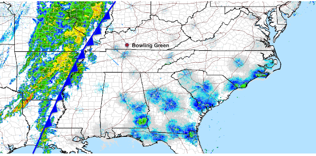
Hi-Res radar courtesy of Noaa.gov


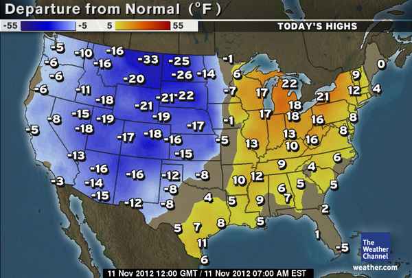
Showers and storms will be moving into the Bowling Green area into Monday morning and afternoon as a cold front sweeps across the southeast. Behind the front, we will see much colder temperatures which is change from the warm up we experienced this weekend. We see highs this Sunday as of 7:00 AM EST (6:00 AM CST) in and around 5-10 degrees above normal for this time in the month of November.


Photo courtesy of weather.com showing temperature departures from normal.


As we examine the latest RUC model analysis of surface temperatures, you can clearly see the colder air mass in behind the front that will bring us the drop in temperatures for Monday and Tuesday. With the displacement of the surface low to the north west, we will see our chances of severe weather be cut down significantly. We do see a strengthened area of positive vorticity that will enhance upper level support into Monday. We also see pocket of elevated wind shear that will support lifting and provide a hail threat as upper level temperatures will be substantially cold. The main threats will be high winds and hail. The event will likely be in the nature of a squall line. Another inhibition will be the earlier in the day timing which will mean less daytime heating and energy for developing storms.  After the cold front passage, We will see our winds shift from the south to out of the north west as the front progresses through the area bringing much colder drier air into the Bowling Green area.


RUC surface temperature analysis for 23 UTC


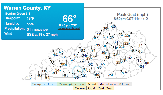
We are seeing winds increase throughout the day here in Bowling Green. The Kentucky Mesonet shows peak wind gusts of up to 36 MPH in Warren County as of 6:50 CST. These winds are increasing in response to the tightening pressure gradient we are seeing across western Kentucky as the system is moving eastward.


Photo courtesy of kentuckymesonet.org

Looking into Tuesday, we will see a dry out with temperatures more normal to this time of year. Temperatures could drop below freezing Tuesday morning as that cold dry air continues to funnel in from the north west. Wednesday could also see below freezing temperatures in the morning hours and chilly temperatures remaining throughout the day. Wednesday our winds will shift to the north east as surface high pressure builds in behind the previous system. A weak upper level disturbance will move towards the area deepening somewhat as it approaches our area. We can expect some light showers to possibly develop with this system. Forcing will be lacking for any severe weather/thunderstorm potential.


Forecast Overview:

Monday: High 48,. Low, 43. Winds SSE, 5-15 knots. Rainy cloudy conditions to persist throughout the day. Slight chance of strong to severe thunderstorms.


Tuesday: High, 49. Low, 28. Winds NW, 5-10 knots. Clearing conditions with a cool down. Freezing temperatures possible in the morning hours.


Wednesday: High, 51. Low, 26. Winds NE, 5-10 knots Light showers possible. Partly cloudy conditions.

Posted in Uncategorized | Comments Off on Severe Weather Potential for Monday and Beginning of the Week Forecast

Showers, Major Cool Down to Start the Work Week

It is an absolutely beautiful Saturday in south-central Kentucky. A ridge of high pressure over Bowling Green (Figure 1) kept skies clear overnight, and fair weather will hang around until Sunday night. The Saturday morning low temperature was 42 degrees, and the afternoon high will be in the lower 70s. Sunday will be very similar to Saturday, with sunny skies and highs in the lower 70s. Get in your outdoor activities before the end of the weekend, folks, because Monday morning will be a return to dreary November weather.

Figure 1. 6 AM Saturday 500 mb Analysis.

A deep 500 mb trough (Figure 1) is located over the western United States and this feature will swing across the Plains today and into our area later on Sunday.  At the surface, the pressure gradient will tighten as the mid-latitude cyclone approaches, which will provide gusty winds on Sunday.  Sustained winds of 15-25 mph with gusts to 35 can be expected.  The surface low pressure center is expected to track northeast towards Lake Superior and then into Canada.  The system will feature a long cold front extending the full width of the U.S. (Figure 2) Current models have the front arriving Monday morning, so expect widespread showers and isolated storms overnight Sunday night into Monday morning.

Figure 2. Surface cold front at 6 AM CST Monday.

At this time, severe weather is not expected with the passage of the cold front.  The Hydrometeorological Prediction Center (HPC) is forecasting system rainfall totals in the 0.50″ – 0.75″ range through 6 AM Tuesday morning (Figure 3).

Figure 3. System total precipitation through Tuesday morning.

Polar air will flow into southcentral Kentucky on Monday behind the cold front, so expect the temperature to drop during the day on Monday from the mid 50s down to the upper 40s.  The clouds are expected to clear out to the east by Monday evening, so Monday night will be cold. The overnight low will be in the upper 20s, and Tuesday will be sunny with highs in the upper 40s.

Bowling Green, KY Forecast:

Saturday: Sunny. High 72.

Saturday Night: Clear. Low 46

Sunday: Sunny and windy. High 72.

Sunday Night: Showers and isolated storms. Overnight low in the mid 50s, dropping throughout the day Monday.

Monday: Cloudy. High 52, dropping into the upper 40s.

Monday Night: Clear. Low 29.

Posted in Uncategorized | Comments Off on Showers, Major Cool Down to Start the Work Week

Rainy Election Night, Warming Trend Starts Thursday

Tuesday has been overcast and cool thus far, with afternoon temperatures in the lower 50s. A shortwave trough (Figure 1) is currently affecting Bowling Green’s weather, and it is expected to continue to dig southeast to further affect the forecast for Tuesday night into early Wednesday morning. Before the clouds set in from the northwest Tuesday morning, the temperature did fall to 34 °F. Current enhanced infrared satellite imagery (Figure 2) shows the heavier cloud cover over Illinois, Indiana, and western Kentucky.

Figure 1

Rain showers over these same areas will move southeast this evening into tonight, so expect a wet and chilly evening as you watch election results roll in. Cloudy skies will remain through the night and through half of Wednesday. Overnight lows will be in the lower 40s.

Figure 2

The clouds will persist until Wednesday afternoon, so expect highs only around 50 degrees. A ridge of high pressure begins building into the region Wednesday night into Thursday, and this feature will produce warming each day into the weekend. The NAM (Figure 3) shows surface temperatures rising back into the mid 60s by Friday.

Figure 3

Bowling Green, KY Forecast:

Tuesday Night: Rain. Cloudy, with a low around 42.

Wednesday: Cloudy in the morning, partly sunny in the afternoon and evening. High 50.

Wednesday Night: Clear. Low 32.

Thursday: Sunny. High 58.

Friday: Sunny. High 65.

Posted in Uncategorized | Comments Off on Rainy Election Night, Warming Trend Starts Thursday

Time Falls Back this Weekend… Will Temperatures Fall Too?

What a nice week to end October and move into November.  Skies have been generally sunny all week despite temperatures that have been slightly below average.  Temperatures should be in the mid-60s for this time of year in Bowling Green but highs have been in the 50s to near 60 this week.  As for overnight lows, Bowling Green fell to 30 degrees Thursday morning which is one of the coldest nights we’ve had thus far this fall.  There has been a gradual warm up in temperatures this week and this slow warm up should continue into this Saturday before yet another trough dips down to encompass southern Kentucky by Sunday.  As the trough and the jet stream dips to our south, slightly cooler air will once again filter into our area.  Until then however we will be on the southern edge of a trough but very near the southern edge of the jet stream as a ridge tries to build in. Generally when this jet moves to our north we warm, and when it moves to our south we cool down, thus this week with the jet stream virtually speeding by directly above us temperatures have been fairly consistent and neither warm nor cold.

NAM 300 mb heights/winds forecast for Saturday afternoon. Temperatures will gradually warm thanks to being on the south side of jet stream but overall temperatures will be relatively neither warm or cold.

Thus until the trough dips in on Sunday expect temperatures to be warming ever so slightly. A shortwave is expected to move through Saturday afternoon ahead of the trough which could bring enough lift to create a few showers.  Rain chances Saturday afternoon are about 40% though any rain that does fall should be very light with a 0.1 of an inch of rain at the very most.  The system lacks a strong forcing mechanism as warm thermal advections and positive vorticiy advections will be very weak if present at all.

NAM forecast vertical velocity (rising air) at 7 pm Saturday. Increased vertical velocity here in southern Kentucky at this time just ahead of the shortwave (yellow dashed lines) indicates rising air and thus a chance of rainfall.

In summary, expect a very slow warm up through Saturday followed by increased cloudiness as rain chances enter the picture Saturday afternoon.  Cooler air will once again try to spill its way in by Sunday.  Looking longer term into early next week, models somewhat disagree to the strength of another trough axis moving through, nevertheless, more troughing is expected and thus cool weather will likely continue.

Daily Forecast:

Friday: Low: 40  High: 63  Mostly sunny skies with increasing high clouds late in the day.  Northwest winds will become more northerly; speeds from 4-9 mph.

Saturday: Low: 35 High: 64  Mostly cloudy skies will become overcast with a 40% chance of rain after noon.  Rain will be light with up to a 0.1 of an inch possible.  Winds from the north-northeast turning to the north at 5-10 mph.

Sunday (Daylight Savings Time Ends: Fall Back): Low: 41  High: 57  Partly to mostly sunny with light north winds between 3-8 mph.

Posted in Uncategorized | Comments Off on Time Falls Back this Weekend… Will Temperatures Fall Too?

Sandy: A Trick or Treat for Kentucky?

After an exceptionally warm week last week, colder air made a return to the Commonwealth Friday and the colder temperatures and clouds stuck around for much of the weekend.  The cold front that ushered in the colder weather weakened as it moved to our east thanks to a very strong low pressure system moving up the east coast named Hurricane Sandy.  Speaking of Hurricane Sandy, this tropical system will quickly become extra-tropical as it gets absorbed into a negatively tilted trough that currently extends from southwest Ontario down into Kentucky.  The system is expected to make landfall somewhere along the New Jersey shoreline Monday evening and wreak havoc on much of the northeast and mid-Atlantic states.  Any impacts for us here in Kentucky??  Despite what you may initially think, our weather for much of this week will actually be controlled by post-tropical cyclone Sandy, but will she bring us a trick or a treat?  The biggest impact on central Kentucky will be blustery winds.  Winds will likely be sustained between 20-25 mph on Monday and between 25-30 mph on Tuesday; winds could gust between 35-40 mph.

NAM sea-level pressure and surface winds in knots for mid-day Tuesday. Winds are expected to be between 25-30 mph with gusts over 35 mph!

Sandy will also force the trough to stay put and thus we here in Kentucky will remain fairly cool.  Overall, low temperatures will fall into the 30s while highs will only be reaching into the low to mid 50s.  Skies should stay predominately clear however, as south-central Kentucky will be located in an area of dry air throughout most of the week. Occasionally some high clouds may move in from the east off of Sandy though the clouds should stay mainly to the east of I-65.

A conveyor belt of dry air will move over western and central KY bringing dry weather and sunny skies. Meanwhile eastern KY will deal with clouds and rain/snow.

Overall the week will be nice and sunny and if you can overlook the strong winds and cooler temperatures you might consider the weather a treat.  As for eastern parts of Kentucky… Sandy Snow???  Now there’s a trick! Winter storm warnings have been posted for Pike, Letcher & Harlan Counties in extreme eastern KY as up to a foot of snow is possible in some of the higher elevations near the VA border; as of Sunday night light snow had already began to fall in these locations.

00Z NAM forecast total snowfall. Heavy Snow is expected over eastern Kentucky near the Virginia border. Winter storm warnings are posted for 3 counties in southeast KY.

Glancing into the later part of the week for us here in central KY, no rainfall is expected and a gradual warm-up should occur as the trough begins to break down..

Daily Forecast:

Monday: Low: 32  High: 54  Sunny skies and windy.  Winds will be from the northwest increasing from around 8 mph early to between 20-25 mph in the afternoon.

Tuesday: Low: 38  High: 57  Mostly Sunny with occasional high clouds.  Windy!  Winds will be from the northwest between 25-30 mph and winds could gust between 35-40 mph.

Wednesday (Halloween): Low: 31  High: 56  A beautiful sunny day and not as windy.  West winds between 12-16 mph.

Thursday: Low: 35  High: 58  A few clouds are possible early before becoming mostly sunny.  West-northwest winds between 8-12 mph.

Posted in Uncategorized | Comments Off on Sandy: A Trick or Treat for Kentucky?

Cold Blast This Weekend

The past couple of days have been pretty boring, but a great chance to enjoy the beautiful leaves and sunshine. The upper level ridge allowing this persistent pattern will begin to break down tomorrow into Friday. A deepening trough from the west is approaching our area bringing strong winds aloft beginning early Friday into the weekend. The pesky ridge is looking to block the main flow of wind to just north of the area. This will reduce the amount of lift over our area. With the surface ridge over our area this past week, the moisture values are less than spectacular. Moisture inflow is shown to be relevant Thursday night into Friday as the surface high finally scoots east. This isn’t too promising since the front is depicted by the NAM and GFS to roll through the area early Friday. There is some discrepancy with the frontal passage though. The mention of upper air blocking earlier makes me think the frontal movement will slow down as time progresses, which is supported by the SREF model. This is coupled with the surface low moving to the far north into Canada’s Hudson Bay. Considering these facts and how it will occur in the morning, indicating a lower temperature gradient, the front should still have enough steam to pass our area. The timing is the issue.

Everything in consideration, I’m predicting an early afternoon frontal passage. Therefore, high temperatures will not reach as high as today or tomorrow. The amount of precipitation is in question. The models are not showing a high probability of precipitation thanks to the diminishing lift and lack of moisture in our area. The front will bring cooler temperatures, but its intensity will be weakening.

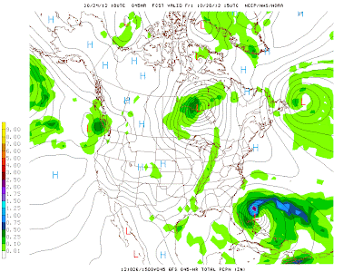
The GFS 10/24 18Z run valid Friday 10/26 at 15Z. It supports both the precipitation and timing predicted for our area.

After the frontal passage, cold air will filter into the region. Lows Friday are looking to drop to the lower 40’s to upper 30’s. Highs on Saturday and Sunday will hover in the 50’s, while the lows hang in the 30’s. Clouds will clear out after the frontal passage Friday as a high pressure settles into our area for the weekend.

Highlights:    High     Low      Precipitation
Thursday:     81         62               0.0
Friday:         72         41                0.1
Saturday:     54         31                0.0
Sunday:       59          37               0.0

Forecaster: Austin Boys

Posted in Uncategorized | Comments Off on Cold Blast This Weekend

Stubborn High Pressure

Current conditions have Bowling Green under the dominance of a surface high pressure system. As Chris stated in the previous forecast, it will linger around through the middle of the week. There is an upper level ridge situated over the central US preventing the influence of any disturbances into our area. This looks to change into Thursday as the ridge begins to break down. The surface high pressure is then depicted by both the NAM and GFS to progress eastward.

The SPC Mesoscale Analysis 850 mb temperatures, dewpoints above 50 degrees F, and heights valid 11pm 10/21. The moisture axis across the central US is clearly visible, as well as the high pressure shielding our area.

Our start to the week is not a complete snooze. The picture above shows the strong moisture axis stretching from the Texas Gulf coast into eastern Oklahoma northeastward into Missouri, Iowa, and Illinois. This inflow of warming temperatures and higher moisture values looks to continue across that area into the middle of the week. This is significant because there is a low pressure system shown to develop along a stalled cold front boundary in the Great Plains. Models depict the associated warm front to extend across the lower Great Lakes eastward starting tomorrow into Wednesday. The low pressure system is not shown to progress eastward but to the north since our area will be shielded by the persistent dome of high pressure, leaving us with little chance of rain.

With this said, expect a dry and beautiful start to the week. Temperatures will stay consistent with today with a slight warming trend. Highs in the upper 70’s and lower 80’s and lows in the lower 50’s. Get outdoors and enjoy the weather, or lack thereof.

Forecaster: Austin Boys

Posted in Uncategorized | Comments Off on Stubborn High Pressure

Weekend update….

The last shortwave along the back side of the upper level cut-off low over the upper Midwest was over central Illinois and Indiana earlier this morning and has continued to dive southward towards Cincinnati.  In return, cloud cover has continued into the afternoon hours and will hang tough into the early evening.  As the low continues its slow progression northeastward, conditions across the Commonwealth will begin to clear from west to east.

Visible Satellite produced and provided by simuawips valid for Saturday 18Z.

By tonight, skies will be mostly clear as the surface high pressure moves into our area.  In return cool overnight lows will be anticipated as temperatures drop into the upper 30’s to around 40 degrees.  As we look to wrap up the weekend, Sunday appears to be a start of a very nice stretch of fall time weather for the Bluegrass.  The stubborn ridge will hang tough over the region bringing sunny and warmer conditions over the next few days.  In general, highs should remain in the low to mid 70’s with overnight lows in the 50’s with sunny conditions.

Posted in Uncategorized | Comments Off on Weekend update….