
That’s right, friends. Clear skies are here and should accompany us through the rest of the week, before the next system moves in this weekend. Low pressure system that has been stalled off of the east coast has finally tracked to the NE. This has allowed breaks in the clouds to transform into mostly sunny skies. High pressure ridge will continue to push in from the SW, contributing to our sunny skies.
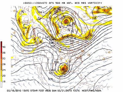
This weekend, we will have a different story. Saturday will start off nice, with clouds beginning to roll in after midday. This will lead to a closed off low pressure system strolling in from the W, making way for showers with embedded storms to push through the region ahead of the cold front. You can view this from the 500mb vorticity model above. Much cooler airmass will flow in behind this, with Sundays high expect to hit in the early morning hours. This cold air advectionis illustrated with the temperature model below. I will have a more detailed post on this system when we get closer to time.

Temperature wise, expect highs for the rest of the week to be well into the upper 60’s, with the lower 70’s a possibility. After the front pushes through late Saturday night/early Sunday morning, expect daytime highs to only reach the lower 50’s to start the new week. Lows for the rest of the week should hang around the lower 40’s. Everyone enjoy the beautiful days ahead before Saturday evening presents us with the winds and precipitation associated with the next system!