
Highlights:
-Warm air and southwesterly flow bringing in higher temperatures
-Chance of showers increasing through the day on Monday.
-Cooler temperatures on Tues.
Discussion:
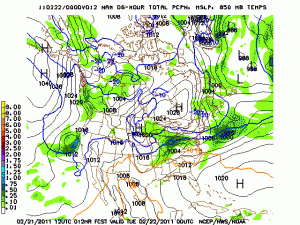
After warm frontal passage on Sunday, southwesterly flow will continue into Monday bringing with it some Gulf of Mexico moisture and a good chance of showers. A low pressure system will move across Indiana Monday night, dragging behind it a cold front which will drop temperatures Monday night into the low 30s.This front should be a focusing mechanism for precipitation, so expect better coverage towards the evening on Monday. Some of the rain showers could be mixed with flurries as cold air filters in Tues. morning, but no impact is expected from this as ground temperatures are too warm. Tues. temperatures will be much cooler with partly cloudy skies, and high temperatures in the upper 40’s.Temperatures increase on Wed. as southerly flow returns in the form of a warm front. This ahead of a late week low pressure system that will affect our area on Thurs. High temperatures on Wed. should top out in the upper 50’s.
Forecast for this evening