
A nasty 594 ridge is poised to bring the Mid-South close to the 100F mark this weekend. Will tropical thunderstorms from the remnants of Dolly keep us from triple digits?
The remnants of Dolly can be seen over the central Plains. At the same time, a potent shortwave north of Lake Superior is beginning to dig southward over the Great Lakes. The front from this system will trigger what could potentially be torrential thunderstorms late Wednesday into Thursday across central Kentucky. QPF guidance suggests that most areas should get 0.75 – 1.50″ although as with all convective precipitation, some places will get very little while some places will get 2″+.
The big ridge will build over the Eastern U.S. this weekend, with Sunday being the hottest day. MOS is predicting that 100F temperatures are possible for Saturday-Monday. If the heavy rains from Dolly materialize as modeled Wednesday/Thursday, there may be enough soil moisture and evapotranspiration to keep temperatures in the 97-99 range. Regardless, this ridge is not expected to be a persistent feature like the one that formed during the record-breaking heat of August 2007.
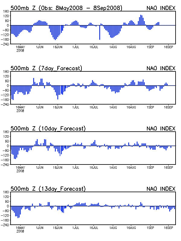
For an East Coast ridge to remain persistent, the NAO must be neutral or positive, which would keep the flow zonal over the Mid-South. Current NAO models predict a negative NAO forming during the first week of August, which teleconnects to an East Coast trough a few days later, as predicted by the GFS. This East Coast trough is supported by the ECMWF and the GFS ensembles.