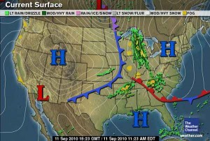
Mother nature looks to be giving us a break today as the severe threat this afternoon has minimized. A warm front will pass through the area late morning, allowing some warm moist air to advect ahead of the advancing cold front that could allow for some re-development of some strong storms later in the afternoon. But models are agreeing in some weakening of the low level winds which will lessen the convergence ahead of the cold front. Re-development is still possible but not as likely as previously predicted. So still keep an eye on the sky, I will update and inform you of any changes through out the day.
Otherwise, enjoy the sunshine the first part of the day as clouds will move back into the area in the afternoon. Will likely see some showers throughout the day, with a possible stray thunderstorm. High 87. Low 63.
Tonight: Cold front should pass through around dinner time and all chances of rain should diminish by 8 p.m.
Sunday: Mostly sunny, with a nice northerly wind to help keep the high at 81. North winds 5-10 knots.

