Days at a glance:
Monday: High – 67 Low – 46 Precipitation – 100% moderate to heavy rain ending completely by noon with peak intensities around 5-7 am. Winds – 16-18 mph S switching and slackening to 5 mph WNW by midnight Skies – Overcast clearing out into the evening
Tuesday: High – 54 Low – 31 Precipitation – 20% rain around midnight Wednesday morning (confidence: 30%) Winds – 12-17 mph W Skies – Clear becoming mostly cloudy to overcast into the evening and around midnight
Wednesday: High – 46 Low – 29 Precipitation – 20% rain around midnight Wednesday morning (confidence: 30%) Winds – 17-21 mph W Skies – Partly to mostly cloudy
Discussion:
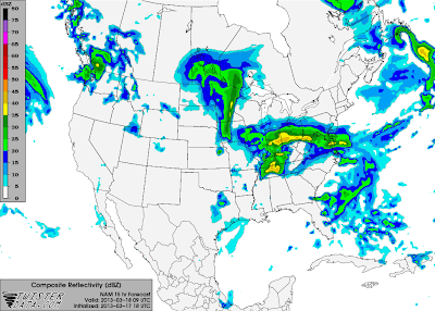
The warm temperatures in the low 70’s we experienced earlier this weekend will reappear shortly into tomorrow before colder temperatures return. A frontal boundary is currently stalled in an east-west orientation across our area. This is the stalled cold front from the beginning of the weekend. Precipitation has been mostly light, but persistent along this boundary today as southerly winds across the deep south bring moisture into the area. With temperatures currently at 42 F in Bowling Green, precipitation will stay in the form of rain as temperatures will remain in the 40’s and warm through the night due to warm air advection preceding tomorrow’s cold front. Rain will taper off overnight as an approaching low pressure system lifts the warm front to the north of our area. Temperatures will rebound nicely into the low to mid 60’s tomorrow under cloudy skies before a cold front sweeps through the area around 3-5 pm. Precipitation associated with this front will come much sooner around early to mid-morning hours before moving out by noon with 5-7 am being the hours of peak intensity. Due to the timing in the early morning, lack of wind shear, and marginal instability, the threat for severe weather will be low with small hail and damaging winds as the primary threats. Widespread and persistent rain will be the main story. Overall, rain amounts could reach up to 1 inch in our area with .65 of an inch as the baseline by tomorrow afternoon.
 |
| NAM 9Z (4 am) 3/18 Composite Reflectivity. Notice the precipitation beginning to reach our area in association with the cold front. |
Monday night, skies will clear allowing temperatures to fall at or below freezing. Tuesday will be a nice day with a high in the low 50’s. The second feature of concern is a clipper system affecting our area around midnight Wednesday morning. Current sounding profiles for that time are not very promising for anything other than a few hundredths of an inch of rain. Since the temperature will be close to freezing and it is still a few days out, updates will be issued if conditions change.Wednesday will have a high in the mid 40’s with partly cloudy skies.
Forecaster: Austin Boys
