
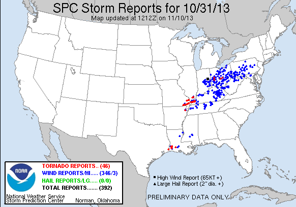
November has come in quietly after the spooky Halloween severe weather stretching across most of western and central Kentucky causing wind damage, flooding and even a few tornadoes.
After the passage of that system and an additional cold front, November started out with chilly temperatures dropping into the 30’s with highs in the 50’s. The first week of November will bring us more rain chances into Wednesday and Thursday as another system drags a cold frontal boundary across our region. Wednesday night areas west of I-65 will begin to see rain becoming more widespread into the night and morning Thursday as a line of showers moves through with the front. After this system clears out, the rest of the week will remain dry with few clouds and cool conditions.

NAM Surface Temperature Valid for 9 pm Wednesday CST.

NAM Forecast Composite Reflectivity Valid for 9 pm Wednesday.
Tuesday: High,67. Low,44. Few broken clouds with winds from 5-10 mph. Mostly dry conditions with few scattered showers for areas west of I-65.
Wednesday: High,70. Low,48. Clouds increasing during the day with winds from 10-15 mph. Rain chances increasing into the evening especially for areas west of I-65.
Thursday: High,58. Low,43. Overcast with widespread rain showers clearing after frontal passage around 6-7 am. Cooling down with winds from 5-10 mph.
Friday: High,60. Low,46. Broken clouds with winds 5-10 mph.
Next Update: Nov. 6th
Forecaster: Emily Thornton