
Days at a Glance:
Monday: Starting in the mid 40’s and rising to the mid 50’s under blue skies. Gusty NW winds averaging 12-17mph will make it feel on the colder side than temperatures suggest.
Tuesday: A calm and clear night will produce a morning low at or just below the freezing mark with highs barely scraping 50 under clear skies. Winds will be light and variable.
Wednesday: Another calm and clear night produces lows at or just below freezing. Highs will reach the low to mid 50’s under blue skies with 6-10 mph winds out of the S-SE.
Discussion:
After a very dramatic severe weather day across the Ohio River valley and Great Lakes region especially, we will settle back down into a quiet weather pattern.
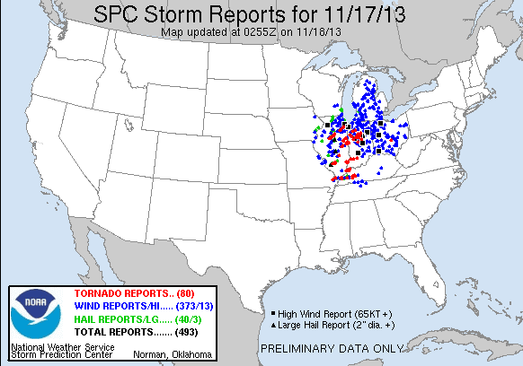 |
| Initial SPC severe weather reports for today as of 8:55pm CST today. An overall devastating event for the Midwestern US. As of yet, Warren County had 0 reports recorded. |
A high pressure system is currently shifting over our area from the west and will park it for the remainder of the forecast period. This will produce beautiful and pleasant fall-like days.

Models are depicting another blast of Arctic air near the end of the work week and into the weekend behind a relatively weak front. More on this development with Wednesday’s forecast.
Forecaster: Austin Boys