
Today’s Forecast
Good morning and happy Wednesday! I hope everyone has had a great week so far and enjoyed the much needed sunshine! Unfortunately, the sun will go away for tomorrow, bringing with it gusty winds and rain. For today though, we do get another batch of beautiful weather. With a high of 67, light gusts increasing to heavier gusts will start to bring in some clouds as we head into the evening. As the rain begins to move into our area we see a slight chance for showers tonight. Heading into tomorrow, the chance for showers ramp up, with the biggest chance during the afternoon. These showers can contain some storms with winds as gusty as 30mph. With high winds any loose or unsecured items are able to be blown around, so make sure to secure anything that might be loose outdoors. Luckily, storms will die off throughout tomorrow night, leading to a beautiful and sunny weekend with highs for Friday in the mid 50s and highs for Saturday in the lower 50s.
Recent Wild Weather
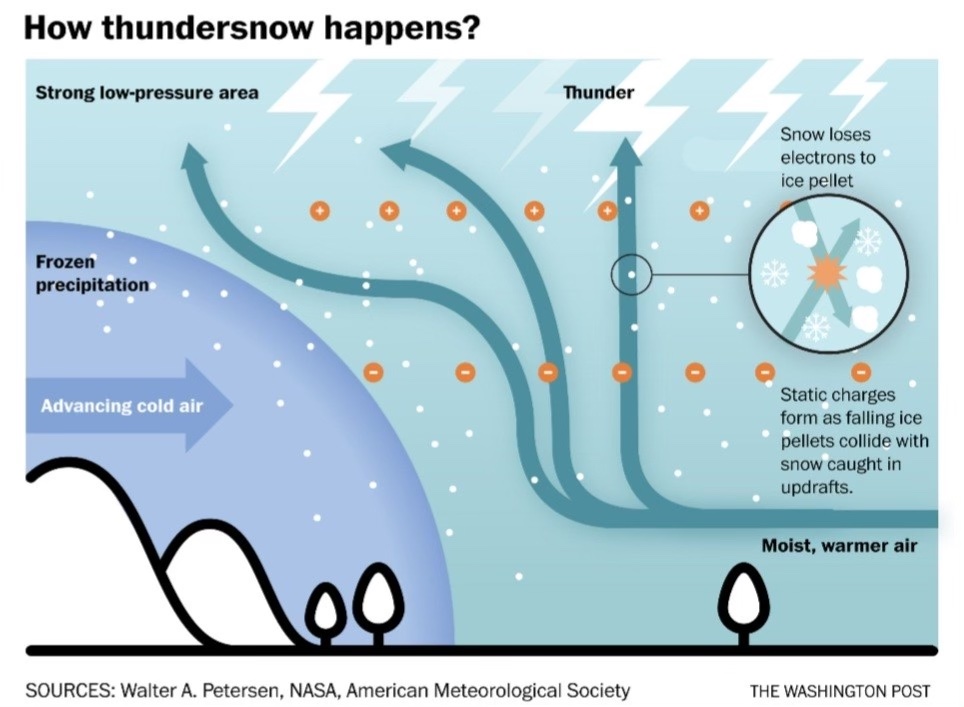
This week in wild weather something happened that brings all the weather nerds (like me) a lot of joy! If you ever saw the famous thundersnow video with Jim Cantore, then you know what I’m talking about. On Sunday in Upstate New York, near white-out conditions were occurring during a snowstorm. This snow storm brought with it 6″ of heavy snowfall, 40 mph wind gusts, lightning, and yes, thunder! Thundersnow can occur anywhere heavy snow is falling, and the NOAA National Severe Storms Laboratory says it can also be observed downstream of the Great Salt Lake and Great Lakes during lake-effect snowstorms. Although thunder and lightning are typically associated with thunderstorms, and while rare, there is always the possibility to hear it accompanied with a snowstorm.
Wild Weather this Day in History
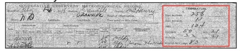
On February 21, 1918, a record breaking temperature increase happened in Granville, North Dakota. In the early morning hours the temperature hit it’s low for the day at 33 degrees below zero! By the time afternoon arrived it would climb an impressive 83 degrees bringing the high for the day to 50 degrees. It probably felt like they were having a heat wave after the very frigid night they had just experienced. This quick warm-up was caused by Chinook winds. Chinook winds are a region-specific term used for Foehn Winds in the lee of the Rocky Mountains in the United States; Foehn Winds are warm, dry winds that occur in the lee of high mountain ranges. It is a fairly common wintertime phenomena in the mountainous west and in parts of Alaska.
I hope everyone has an amazing rest of the weekend and stays dry tomorrow!
Sources: https://www.foxweather.com/learn/thundersnow-what-causes-lightning-and-thunder-during-a-snowstorm.amp https://www.washingtonpost.com/climate-environment/2022/11/18/how-thundersnow-happens-explained/ https://forecast.weather.gov/glossary.php?word=CHINOOK#:~:text=Chinook,and%20in%20parts%20of%20Alaska