Rain Late Saturday and Early Sunday PLUS Pattern Seems to be Changing

Both the NAM and the GFS seem to be in better agreement for 36 hours out from the 12Z run. Both are forecasting a widespread rain event, with the only difference being the GFS is wanting to soak the Deep South with heavier rain as opposed to the NAM. For The Mid-South this event looks to mainly bring steady to heavy rain, and maybe some thunderstorms, however, no significant convective activity is expected, as it appears clouds will hinder any major diurnal heating in the warm sector.

Also, for the long term forecast, the GFS is suggesting a change in the pattern, bringing a polar vortex over Canada, based on the 500-mb vorticity and heights plot. Granted this is 144 hours out, but it is definitely something to consider for long term forecasting. However, it is also important to note that the NAO is still forecast to remain positive, and not much change in the AO is expected either.

Posted in Uncategorized | Comments Off on Rain Late Saturday and Early Sunday PLUS Pattern Seems to be Changing

Abnormally Warm Winter Looks to Remain Warm

While the Winter of 2010-2011 had a La Niña, it also saw anomalously negative NAO and AO throughout much of its entirety.  Winter 2011-2012 has seen La Niña as well, only as anomalously negative as NAO and AO were last winter, this winter they have been as anomalously positive, and that pattern does not look to break any time soon.

As for the short term, a shortwave is moving through the area triggering some shower activity, albeit of a more scattered nature, and mainly in Tennessee.

Shower activity should continue throughout the day.  A more organized and widespread event can be expected over the weekend.  The 06Z run of the NAM and GFS have moved the arrival of this system to Saturday as opposed to Sunday, with the NAM being a bit more progressive at 84 hours out than the GFS.  The GFS wants to keep the ridging intact with the NAM breaking the ridging down.

As observed on the 84 hour 1000-500mb Thickness/MSLP charts from the 06Z run, the NAM also is more aggressive with the precipitation, as well and has the system being better organized as well.  One consensus of the models is that this will definitely be a rain event, as has been the recurring theme of many storm systems over the past several weeks.


Posted in Uncategorized | Comments Off on Abnormally Warm Winter Looks to Remain Warm

Two Chances for Precipitation Over the Next Week

The mild winter influenced by La Niña and very positive NAO and AO continues as a ridge of high pressure is in place over the East Coast providing solid warm air advection into the Mid South this morning.

The day will start off cold, but the southerly flow will bring in more warm and moist air and allow temperatures to reach into the upper 50s, and set the stage for a rain event come mid week as a trough will pass through the area by Thursday. Temperatures will rebound quickly and a second system will send a wave of energy through the mid south bringing bigger chances of rain for Sunday.

For the midweek event, the GFS is not as aggressive as the NAM is with the cold air. Based on the abnormally warm nature of the pattern in place, a solution closer to the GFS is a good bet. As for the Sunday precipitation, the GFS is suggesting a very warm set-up—much too warm for any wintry precipitation. There could even be the chance for severe weather on Sunday, but that is a very remote possibility as of now. The SPC does not have anything plotted for Sunday in regards to convective activity.

Posted in Uncategorized | Comments Off on Two Chances for Precipitation Over the Next Week

temp forecast revised today

lowering highs to 40-45 today
1. slower clearning expected
2. stronger CAA

Posted in Uncategorized | Comments Off on temp forecast revised today

Weekend forecast

The spring term has started at WKU. This means this site will continue to feature frequent weather updates with many authors about the upcoming weather patterns!

1. This weekend We will continue to see a zonal flow with a few week troughs moving through.

2. Friday our rainmaker departs with slowly clearing skies. I’m not expecting fog as winds should be from 5-10 MPH. After morning lows in the mid to upper 30’s highs should be around 50.

3. Saturday the first trough moves through with a very week cold front. Ahead of the front some WAA should keep lows in the mid to upper 30’s. Only expect a slow rise into the low and mid 40’s with CAA behind the front. This front should provide enough lift for clouds along with a very small chance of light rain or flurries. Winds should increase some with the front as well.

4. A week shortwave passes to our northwest Sunday Ahead of it  my thinking is enough sunshine and WAA should allow for highs in the upper 40’s more in line with the ECMWF after lows near 30. Another period of clouds late Sunday is likely as well, will keep Sunday dry though as moisture is even more limited than on Saturday.

5. Long range euro is the same as last week very warm and wet for Feb.

Posted in Uncategorized | Comments Off on Weekend forecast

More severe weather Sunday night/Monday likely

This is a long forecast given i will be in New Orleans from Saturday through Wednesday for the AMS conference. This means I will not be able to update any severe warnings Sunday Night/Monday. I may ask someone else to cover as well.

Here is a link to the AMS conference http://annual.ametsoc.org/2012/

Locally there will be a weather conference in February @ the Holiday Inn in Bowling Green. I hope to meet some of you there. A great chance to learn all about weather and meet meteorologists in the region!

http://kyem.ky.gov/Pages/default.aspx

Let’s get to the weather

1. A major bust by almost all meteorologists out there, even had to slap myself silly after missing this one. It only takes a small amount of instability with lots of shear to make a situation very threatening. Should have been watching the soundings closer. No watches were issued by the SPC this has happened many times in recent months including my time at NWS-PHL. Severe reports keep coming in and no watch is issued. UMM…..

2. Friday will see a boundary over our region which will lead to dramatically different temps across the state. Lows will be near 30 south. Highs Friday in the south may make the low 50′s with Southwest winds  increasing from 10-20 MPH. A low pressure system will track across the region Friday night bringing moisture with it interacting with the boundary and producing light rain known as isentropic lift. Friday night temperatures should rise into the low and mid 50′s. Some elevated thunder is possible as well but any instability should stay south of the region.

3. Temperatures Saturday should be in the 40’s as we clear out.

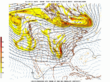
4. Sunday another surge of Warm air advection WAA  will bring much warmer weather and south to southwest winds at 20-30 mph. lows will start out in the 30′s maybe low 40′s  with highs in the 60′s. Sunday night a strong cold front should move through with rising temps once again at night. The overall trough will be negative tilted, a strong LLJ will also be present. A impressive vort max should be moving just to the west of the region as well.

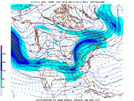
A look at the 300 mb jet notice a nice piece of jet energy moving in

A look at the soundings shows the LLJ to be impressive from 60-80 KTS, helicity values should be the roof again a key indicator of updrafts needed for storm rotation. Sufficient instabilty appears to be present at this time for another severe weather event either Sunday night or Monday morning.

A squall line of thunderstorms should bring widespread severe weather sometime Sunday night or Monday morning with the frontal passage. High public impact. I strongly disagree with the SPC that this is a non event. That type of talk last time lead to a very bad forecast day there Tuesday. Apologies for not being able to post warnings in advance due to my absence.

5. Monday should clear out a bit lows will be in the 30′s with highs in the  40′s.  Tuesday and Wednesday I’m keeping dry with highs in the 40′s maybe low 50′s and lows in the 30′s to maybe around 40.

Last week the long range euro showed promise of colder times for the first half of Feb, this week’s run has been replaced by record warmth and lots of it.

Posted in Uncategorized | 1 Comment

More storm recap Thursday update

http://www.crh.noaa.gov/lmk/?n=jan17_2012

Storm recap Above thanks to NWS LMK!  Great job getting the damage surveys done!

I will update on thursday real quick now. Then tommorow I’ll post my forecast from Friday through Thursday of next week.

A cold front will move west to east across the region with a chance for light rain showers. Lows will be in the mid to upper 20′s with highs in the upper 40’s.

Long term models are backing off the extreme warmth some and teleconnections are showing a more favorable pattern for snow and cold once Feb arrives.

Posted in Uncategorized | Comments Off on More storm recap Thursday update

Severe thunderstorm warning in effect

A storng storm will move through Warren county in the next hour with gusty winds up to 60 mph.

Posted in Uncategorized | 1 Comment

Mesoscale discussion #1- severe threat today

. SPC mesoanalysis shows an advection of moisture dewpoints close to 60*F, Mixed layer CAPE values of 500 J/KG, Helciity values of over 500 m/s ^2 advecting into Western kentucky.

– A squall line of strong storms has moved into the Ohio River valley as well with severe storms just West of Louisville, won’t talke much mixing to get strong winds down to the surface.

– Threat for damaging winds across this entire region with a tornado threat further south and west today.

Posted in Uncategorized | Comments Off on Mesoscale discussion #1- severe threat today

Warm pattern returns

We’re on the snow board now with 1.4 inches for the season. The talk of a snowless winter actually ended Jan 2 where .2 inches of snow fell officially where many just saw flurries.

Hope you enjoyed the snow b/c we’re going back to the same old pattern I’ve hated all winter.

This – PNA forces a southeast ridge and dumps any cold into the west, it’s back where it was in NOV. And is the reason why any systems the next few weeks cut well to our west and most days are very mild through the end of Jan once this airmass in place leaves. Any cold shots are brief.

1. Monday will see a return to southwesterly flow which will cause some week isentopic lift to take place leading to increase in clouds, a light rain shower can’t be ruled out the best chance Monday should be from Little Rock to Indy where the isentopic lift is more pronounced. Lows should be in the  mid 30′s and Highs should climb into the  low 50′s. Winds will pick up from 10-20 mph.

2. A low pressure tracks in the lakes Tuesday bringing with it a strong cold front. Ahead of the front SW flow will lead to steady or rising temperatures Monday night. Will lean to the ECMWF with this since it handled the new years front well. Temperatures should rise into the low 50′s south and upper 40′s north Monday night. Southwest winds of 15-25 mph. Periods of rain showers will accompany the front, the SREF has .25-.5 of rain across the region I could see a few amounts near or just over an inch along I-71 which is well north of us. I’m going with  the slower frontal passage on all models not named the GFS. This should allow for a temperature spike from 60-65 on Tuesday for highs.

3. temperatures crash fast Tuesday night into the 20′s with highs getting close to 40 Wednesday. Skies will clear as the wind direction temporarily turns back to the northwest. Thursday may be interesting with a chance of light rain or snow. After that we should really warm-up, good thing my trip to New Orleans for the American Meteorological society is next weekend and I won’t miss any winter. Another blog author will be updating that week.

4. I continue to think around the 7th of FEB the pattern should change as we get another 10 mb warming event over the poles and the latest euro weekly forecast turns cooler around this time as well.  The end of this month should be a transition from the peak of warmth around the 23rd several storms will cut into the lakes, maybe some severe weather as well.


Posted in Uncategorized | 1 Comment