
As mentioned in a recent post the see-saw pattern will swing back to cold this weekend. Thursday’s storm will bring more rain and possibly severe weather to the Mid-South and will bring temperatures down to seasonable levels (low 40s/upper 20s). What happens after that is still uncertain.
A second shortwave is expected to follow the baroclinic zone and develop a low along the Gulf coast over the weekend that is expected to move off the SE coast and possibly bring snow to the East Coast. A separate shortwave may bring a mix of rain/snow showers to the Mid-South on Sunday and yet another stronger shortwave may bring snow showers to the region on Monday. Since northern stream shortwaves tend to track further N than originally modeled I think the best chance for light wintry precipitation in the Sunday-Monday time period will be in the Bluegrass.
Beyond Monday is where uncertainty increases dramatically. The GFS and its ensembles have been consistently suggesting the development of a full-latitude blocking ridge centered over Alaska as seen here in the Wednesday 12z GFS. This is also fairly well represented in nearly all of the Wednesday 12z GFS ensembles, although there is some variation in the location of the ridge and the downstream trough. By day 10, and continuing through day 16, the GFS suggests that the 2nd half of January will feature much below normal temperatures for the area stretching from the northern Rockies through New England, which is roughly the same area that was frigid during the first half of December. The GFS ensembles show much the same thing. Also like in December, the split flow pattern (unusual for La Nina) appears to merge over the center of the United States, which allows the bitterly cold arctic air to collide with moisture from the Gulf which could potentially lead to heavy snows north of wherever the arctic boundary sets up in the Midwest. In short, the model evidence suggests a cold and snowy pattern for the same people who were cold and snowy in the first part of the winter. It is too early to tell how much (if any) of the Mid-South will end up on the cold and snowy versus the mild and rainy part of this type of pattern.
Despite the insistence of the GFS and its ensembles, there is also evidence that this cold and snowy pattern may not even evolve.
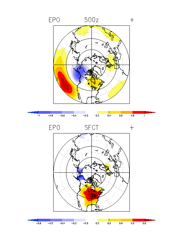
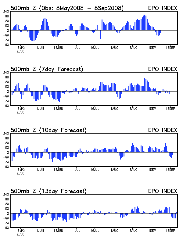
1) A strong full-latitude ridge centered over Alaska is a signature of the negative phase of the East Pacific Oscillation (EPO) as shown here. As shown in the time series of the EPO (top graph), when the EPO is negative (ridge over Alaska), cold air is forced from the Arctic into the eastern U.S., which last occurred from late November to mid December. When the EPO turned positive in mid December (trough over Alaska) the eastern U.S. turned warm. The forecast of the EPO (bottom three graphs) all show the EPO becoming neutral around mid January but then rising towards the end of the month. This conflicts greatly with the pattern evolution shown by the GFS.
2) The European model (ECMWF), which has dominated the GFS in the medium to long range during the past few winters, shows a much more subdued trough over the eastern Pacific with a weaker trough across the central Plains. You can compare the 8-10 day means between the ECMWF (left) and GFS (right) here.
In short, I expect the GFS to back off some from its arctic apocalypse for the 2nd half of January and to show a more zonal pattern based on the idea that the eastern Pacific ridging is probably overdone.