The first day of the class started early in Tulsa, OK where the students were learning the daily rituals of the trip. Each morning the students will conduct their own individual surface analysis and state where they would position the van for the best chance in catching storms. Each student will work alone, but come together before leaving with the professors and explain why each of the students chose those particular spots. After a brief forecast discussion and small debates, the selection is made and we hit the road.
Today, the target city was Wichita, KS where the class and professors both feel is the optimal spot for convection and rotating storms. An upper level trough that is slightly negatively tilted is ejecting out of the four corners region northward. Synoptically, that means just east and northeast of the upper level trough is where the maximum positive vorticity advection will take place along with maximum theta-e advections at the surface. At the surface, a low pressure system located near the CO/KS border will translate northward and bring the advancing warm front northward with it. As the low translates northward, as does the warm front, winds at the surface will become from the southeast. Which is favorable for supercellular development given that the winds are veering with height (winds turn clockwise and increase in speed with height). Bulk shear values range from 40 to 60 knots, where 45 is a baseline value for supercellular development. Moisture has recovered nicely from early in the week bringing dew points into the mid 60’s. Instability is expected to increase throughout the day as the warm front advances north, leaving south of the front to clear skies for maximum surface heating.
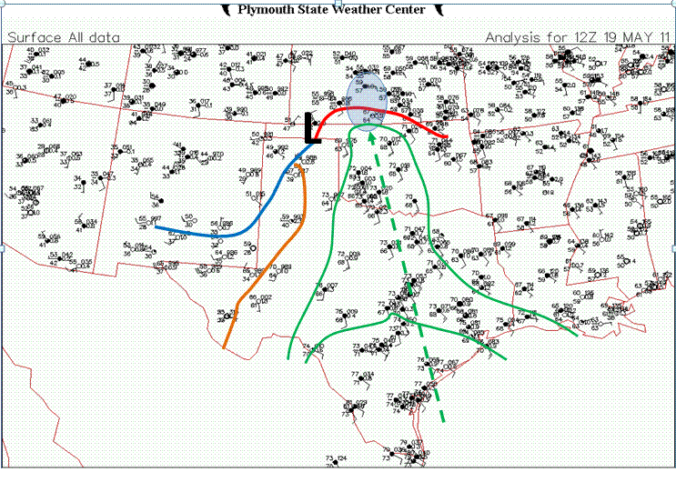
The thought process of students and professors was to move close with the center of low pressure and advancing warm front at the surface where winds will be veered, moisture advections will be maximized, and instability will be the greatest. Here is a surface analysis done by myself (Lee Campbell). Blue circle indicates our target area, blue line indicates cold front, orange line indicates the dryline, red line indicates the warm front, and green lines indicate dew point values (65, 70), and dashed green lines show the fetch off the Gulf of Mexico indicative of the low level jet.
A recap of today will be posted either tonight or tomorrow morning with the best photos taken from the day. Enjoy your day and wish us luck!

