
After waking up in Scottsbluff, we assessed the latest weather data and today’s target looks very unique with respect to targets that we have previously picked. Today looks to be a very marginal day, as it is not a classic low pressure setup that we have encountered so far through this trip.
15Z Surface Analysis
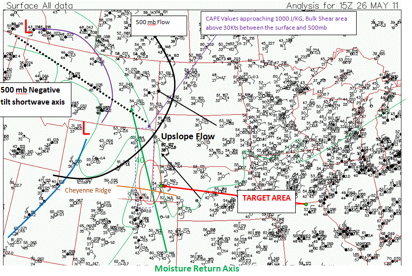
Currently a very negatively tilted shortwave trough axis extends NW to SE across the upper rocky mountains. In response, upslope flow is currently taking place at the surface along the Front Range from Colorado to Wyoming. A moisture and instability axis is currently nosing in along the Front Range as well. Upslope, backed winds should raise dew points into the 50’s and cape values to around 1000 j/kg. Although these are very modest, the higher elevations and terrain features require less instability for convective initiation.
Our target for this morning is Cheyenne, Wyoming. This is on the southern fringe of our target area, due to the fact that the Cheyenne ridge acts as an area of increased topographic lift. We chose this area this morning due to the fact that one of the concerns for today is that all the parameters this morning are very marginal, yet there exists a strong capping inversion over the area. Hopefully the orographic lifting effects of the terrain give us a chance to chase today. For the mean time, since we are so close to our target, we will most likely take in some sights. A recap will come late tonight, hope to bring you some good pictures…..