
Good morning and happy Monday, readers!
Today’s Forecast
For today, we repeat yesterday’s relatively nice weather after the string of brutal cold. Highs today will push 50, with abundant sunshine. Get out there and enjoy the nice weather! Tonight, we dip back down to the lower 30s for overnight lows with mostly clear skies.
What to Watch For
There is great potential for heavy rainfall beginning early Wednesday and lasting through Thursday night. Rainfall in this two-day time frame could exceed 2-3″, causing regional concern for flooding due to saturated ground from previous snow melt. Additionally, Thursday night there is potential for the precipitation to change over to a wintry mix, with freezing rain, sleet, and snow possible. Details are still being refined on that potential, so stay tuned!
Weather Fact!
With the threat of multiple potential precipitation types this week, let’s review the differences in the types of winter precipitation.
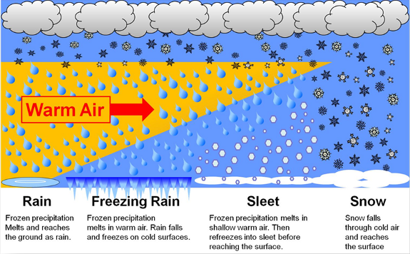
Rain- Rain begins as frozen precipitation in the higher levels of the atmosphere, but melts as it falls with the warmer layers of the lower atmosphere. These layers and the surface have temperatures consistently above freezing to produce rain.
Freezing Rain- Same process as rain except there are freezing or below-freezing temperatures right before the surface. This leads to apparent rain falling, but freezing on contact of many surfaces, creating a glaze of ice.
Sleet- Occurs when there is some melting in the atmosphere in thicker or even numerous levels, but refreezes before it hits the surface and fall as little pellets of ice. These pellets accumulate like snow, and look similar to “Dippin’ Dots”.
Snow- No layers of the atmosphere down to the surface are warm enough to melt the initial ice crystals in the upper layers of the atmosphere, resulting in snowfall at the surface.
Alright, that’s all for today folks. Have a great week, and stay safe if there is flooding or winter weather hazards!