
Today’s Forecast
Good morning and happy Wednesday! I hope everyone has had a great week so far! Chances for thunderstorms this morning is likely, as well as, a chance of scattered thunderstorms throughout the evening. The National Weather Service has us under a hazardous weather outlook for this afternoon and early evening with the primary threats being locally damaging winds, as long as, some chances for hail and localized heavy rainfall. Thursday looks to be a much better day with sunny skies, calm winds, and a high near 83.
Recent Wild Weather
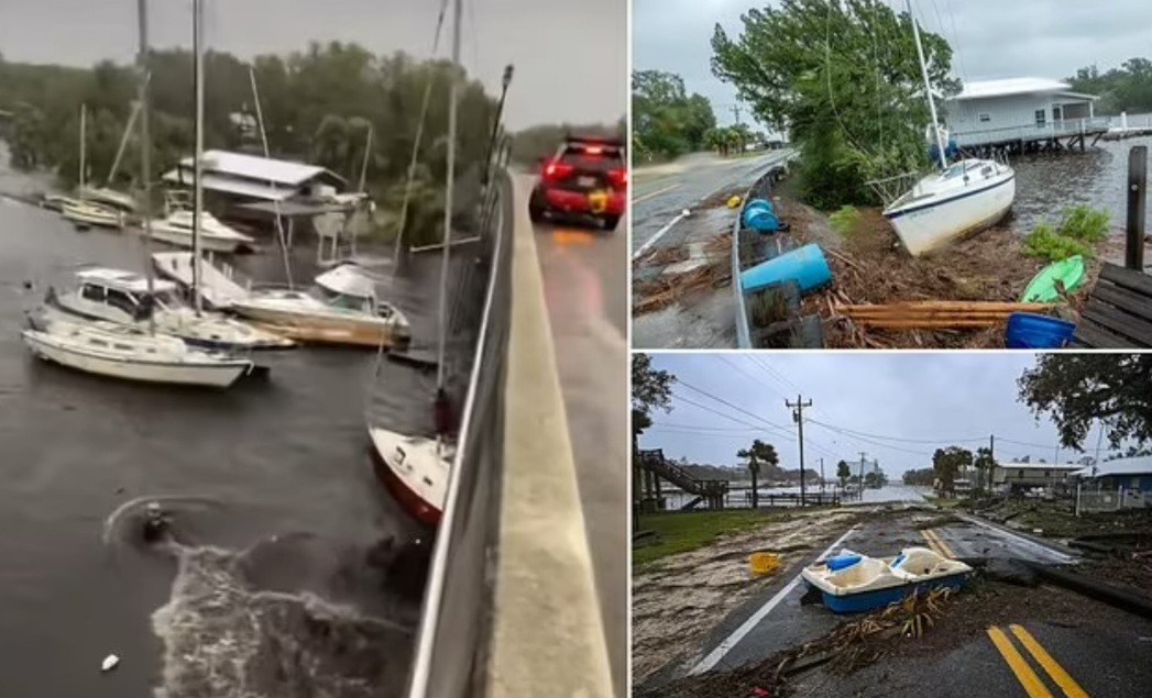
Well, we can’t look back at last week’s wild weather without talking about Hurricane Idalia. Last Wednesday, Idalia made landfall on Florida’s Keaton Beach as a category 3 storm. It had sustained winds of 125 mph, and a 6 foot storm surge due to its heavy rains accompanying Idalia. It left its mark on Florida, Georgia, and South Carolina before it weakened into a tropical storm. Along its path it produced a number of issues including: flooding, power outages, beach erosion, major structural damages, and even loss of life. One of the wildest things I saw being reported on was the reversal of the Steinhatchee River in the Big Bend region of Florida. This is a phenomenon that occurs when extremely strong winds push massive waves in the opposite direction of the normal river flow, forcing the flow to then go backwards until either the normal river flow or the elevation of the land interrupts the process. As the Steinhatchee River reversed, it also rose over 8 feet during the process. Additionally, it made sailboats unable to clear the bridges, ripping off their masts as they attempted to pass under. The reversal of a river flow can be temporary or even become permanent. The town of Steinhatchee has a long way to go to recover from the damage caused by Hurricane Idalia, and the effects it had on the Steinhatchee River.
Wild Weather this Day in History
While we are on the subject of hurricanes, let’s talk about how many have been recorded on September 5th alone. There have been 4 hurricanes to make landfall on this day in history in the US. In 1933, (before we were naming hurricanes) a Category 3 hurricane made landfall on South Padre Island, Texas. The storm caused 40 fatalities and nearly $17 million in damages. In 1950, Hurricane Easy hung over Tampa Bay dumping massive amounts of rain totaling in at 45.20 inches, and causing 3.3 million dollars in damage. In 1996, Hurricane Fran made landfall in Cape Fear, North Carolina. Fran was responsible for 26 deaths and, at the time, was the most expensive natural disaster in North Carolina’s history. In 2017, Hurricane Irma became a category 5 hurricane with maximum sustained winds of 180 mph. Irma is one of the strongest hurricanes ever observed in the open Atlantic Ocean. We are still in hurricane season until November 30th, with the Atlantic’s next major hurricane expected by this weekend.
I hope everyone has an amazing rest of the week and can avoid any possible damages from these potential storms!
Sources: https://www.dailymail.co.uk/news/article-12462411/amp/Hurricane-Idalia-REVERSES-Florida-river-ships-moorings-devastated-homeowners.html https://www.weather.gov/abr/This_Day_in_Weather_History_Sep_05