Southeast Severe Storms Symposium

Hello from Starkville Mississippi! The White Squirrel Weather program here at Western Kentucky University is currently attending the Southeast Severe Storms Symposium. This is the 20th annual meeting here at Mississippi State University. The symposium has speakers come from all over like Joanne Culin from the National Weather Service in Jackson, Mississippi, and Danielle Breezy from WKRN in Nashville, Tennesse. Some special guests included: James Spann from ABC 33/40 News and Amy Freeze from Fox Weather.

This symposium allows professional meteorologists to get together with students to talk about current breakthroughs in meteorology and recent severe weather events. Like reviewing the December 10th-11th, 2021 tornado outbreak or using GIS to inform the public of flood zones. James Spann wrapped up the first day with a great half-hour talk about how to be a successful meteorologist and how to connect with your audience. He reminds you to go out of your way to constantly remind people of the dangers of the weather. James also reminds us that even though the weather is beautiful it is also destructive and tragic.

Our fellow students, Jake Disinger and Cooper Bennett will be presenting tomorrow on the White Squirrel Weather program and how using drones helped to analyze the destruction paths from tornadoes. Afterward, we get to make the six-hour drive back to Bowling Green, Kentucky!

Bret G

Posted in Kentucky Weather | Comments Off on Southeast Severe Storms Symposium

Today in Weather History

Good morning, everyone! Are you ready for the weekend? We sure are!

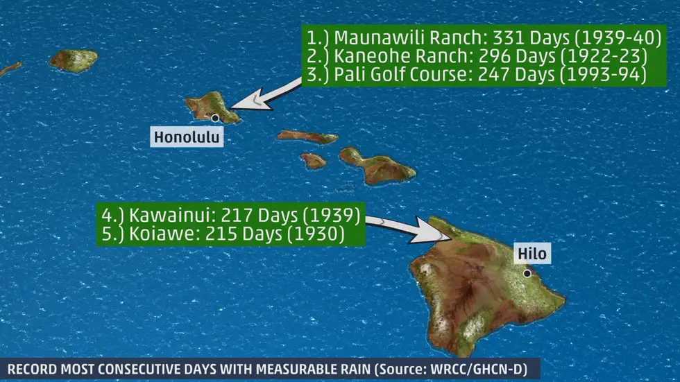
On this day, in 1942, a state that we don’t hear much about, Hawaii, broke records in terms of precipitation. At Puu Kukui in Maui, Hawaii, a total of 107 inches of rainfall was recorded for the month of March alone. How insane is that? Mind you, this location reached an annual record of 578 inches just eight years later.

If you don’t know much about Hawaii (and I will be the first to admit that I don’t), another fun fact is that it once rained 331 days straight in Maunawili Ranch from 1939 to 1940. Below is a graphic that shows this, amongst other parts of Hawaii that experienced close to, but not surpassing, this amount of rain-filled days.

(Source: WRCC/GHCN-D)

Signing off! Have a great weekend!

Posted in Kentucky Weather | Comments Off on Today in Weather History

Severe Weather

Good Afternoon,

Today has been a good day to go outside and take a walk around only 83 more days until summer for all those summer lovers like myself. All of this niceness is not going to last, As we head into the evening a strong cold front is going to push through the region and produce some rain and thunderstorms. Some of these storms may be severe with damaging winds being the primary threat but a few tornadoes are also possible. Make sure you are weather aware this afternoon and evening and have plans in place incase severe weather occurs. The best timing for storms is from 8-11 pm. Tomorrow the high will reach 65 with mostly cloudy skies. Have a good evening and stay safe out there!

Posted in Kentucky Weather | Comments Off on Severe Weather

Today in Weather History

Good afternoon to you! How are you? We hope wonderful!

On this day, in 1848, a particular, abnormal silence in New York stunned the entire nation. The water of Niagara Falls, a group of three waterfalls at the southern end of the Niagara Gorge, stopped flowing. This eerie silence stemmed from an ice jam at the neck of no other than Lake Erie itself and the Niagara River entryway that is between Fort Erie, Ontario and Buffalo, New York. In relating this to weather, the cause of the jam is from the wind, waves, and lake currents.

So, you may be wondering: how often does this happen? Because I know in my lifetime, this has never happened. Well, the answer to that is: this was the only time in history that the Falls stopped flowing!

Today’s history excerpt was fun, wasn’t it? Definitely something I didn’t know! Have a great day!

Posted in Kentucky Weather | Comments Off on Today in Weather History

Mason’s Monday Outlook 3/28

Good morning, folks, and happy Monday!

Today’s Forecast

For today, you can expect a cool and clear spring day. High temperatures will top out in the lower 50s with partly cloudy skies- a very typical March day. For tonight, expect a cool but calm night, with lows in the upper 30s and mostly cloudy skies. Enjoy the calm day!

What to Watch For

If you miss the warmth, you will not have to wait long for its return. Tomorrow will bring temperatures in the mid 60s with building clouds and wind potential. This culminates to what should be a very warm and windy day on Wednesday. Our first 80 degree day of the year is certainly possible on Wednesday ahead of a large rain chance Wednesday night. Stay tuned to the forecast for wind gusts potentially up to 40mph, and rainfall that may reach one inch.

Weather Fact!

With the return to 80s in the forecast, let’s take a look back at the last time we hit 80 degrees here in Bowling Green. According to Kentucky Mesonet, our last 80 degree day was October 14th, 2021, when the high temperature reached 81.5 degrees Fahrenheit. Since then we have seen lots of rain, snow, and cold weather, so if you are a fan of the warmer weather your wait is finally over!

Have a great week everyone 🙂

Posted in Kentucky Weather | Comments Off on Mason’s Monday Outlook 3/28

Chilly Weekend

Happy Friday everyone, and another chilly one at that! With a slight breeze out of the north and overcast skies, it is not going to feel much like a Spring day. The weekend ahead is going to be clear with highs in the lower 50s. Saturday will have winds gusts up to 30mph so make sure to bring in those flags and other things that can be blown around. With it being chilly out and it being National Tolkien Reading Day, why not snuggle under a blanket and read a book?

Posted in Kentucky Weather | Comments Off on Chilly Weekend

Today in Weather History

Good morning, folks! What a long week it’s been, or so it seems! We hope you’re doing well!

On this day, in 1912, the city of Kansas City, Kansas, fell victim to a record-breaking snowstorm. In a twenty-four-hour time period, a total of twenty-five inches of snowfall fell, to which is twice that of the previous record. In this year, the state saw sixty-seven inches of snowfall total, to which also broke the previous record. To this into perspective, the state of Kentucky has an average of eleven inches of snowfall per year, so the singular snowstorm had more than double the amount of that! Incredible!

Have a great weekend!

Posted in Kentucky Weather | Comments Off on Today in Weather History

Nice Weather here to stay?

Good Afternoon!

Spring is finally here warmer temperatures, longer days and plants beginning to bloom these these past few days have really proven that. Over the past couple days highs have been in the upper 50’s to low 70’s Although it rained yesterday the sun is already back out today! As we head into the next couple days temperatures will dip into the mid 50’s with partly cloudy skies through the remainder of the week. The chances for rain will remain low allowing for more outdoor time to go on a walk in the park or perhaps start beginning that time of spring cleaning! Our next chance of rain will come midway through next week, so rest easy until then and enjoy the nice weather! Have a good evening and stay safe out there!

Posted in Kentucky Weather | Comments Off on Nice Weather here to stay?

The Return of Precipitation Chances

Good afternoon to you! For those of you that are students, we hope that you had a wonderful break!

Today, cloud cover has slowly but surely become overbearing ahead of a cold front extending from an incoming low pressure system. There remains a scattered likelihood for showers for the rest of the day, but these chances will become widespread into the overnight hours. Our main concern will be with the potential for gusty winds (up to 30 miles per hour) and brief, heavy rainfall that will pose a threat for localized flash flooding. If you are someone that commutes to work, be cautious on the roadways in the morning, as the accumulations of rainfall may result in slick roads and areas that are flooded.

That’s all for today! Have a great one!

Posted in Kentucky Weather | Comments Off on The Return of Precipitation Chances

Mason’s Monday Outlook 3/21

Good morning, folks, and happy Monday!

Today’s Forecast

Yesterday was the official first day of spring, and today’s forecast will surely reflect that. As the cherry blossoms begin to bloom across Western Kentucky University’s campus, temperatures will soar into the lower 70s today, with mostly sunny skies. Tonight, clouds build in before a rain chance tomorrow. Temperatures drop into the lower 50s, with winds gusting between 20 and 25 mph.

What to Watch For

The week looks pretty calm overall, with only a rain chance Tuesday into Wednesday serving as a potential concern. Rainfall between 1/2″ to 1″ possible, and a few thunderstorms cannot be ruled out Tuesday afternoon into evening. At this time, only a marginal risk for severe weather exists for those thunderstorms. Stay tuned for any updates or changes with that forecast. After the rain moves out, temperatures will be cooler, but not cold.

Have a great week everyone 🙂

Posted in Kentucky Weather | Comments Off on Mason’s Monday Outlook 3/21