Potential for Frost as Temperatures Plummet

Good evening, everyone!

As of now, the National Weather Service does not have our county within a freeze advisory or warning, but that does not mean that it is out of our sights in the early hours of the day. In preparation for this, we would advise for you to cover any sensitive vegetation and wrap unprotected outdoor plumbing. If you are out and about in the morning, be sure to bundle up, as temperatures will be right on the brink of below freezing. Other than that, be ready to scrape off those windshields! Later on in the day, temperatures will increase to the lower 50’s with the sunshine offering some additional warmth. Regardless, a jacket will definitely be necessary with the presence of crisp, calm winds.

Have a wonderful week!

Posted in Kentucky Weather | Comments Off on Potential for Frost as Temperatures Plummet

Wednesday Freeze!

Good morning, and happy Wednesday, readers!

Forecast

The chilly fall air we have been experiencing will intensify tonight. For today, look for temperatures to remain cool, but pleasant. Temperatures will max out in the low 50’s with partly cloudy skies. Overnight, clouds clear out and allow temperatures to plummet into the upper 20s.

With temperatures expected overnight to be below freezing, the National Weather Service in Louisville has issued a Freeze Warning for the area. This signifies the first freeze of the fall/winter season, and will effectively end the area’s growing season. With temperatures in the upper 20s, the area will be on the edge of a “hard freeze” (temperatures below 28 degrees), which brings a serious concern to damaging vegetation. Make sure to protect your vegetation if necessary!

Weather Fact!

The last time Bowling Green recorded a low temperature below 32 degrees, or freezing level, was on April 3rd this year. (Kentucky Mesonet)

Time to bring back out those winter coats! Stay warm out there, folks!

Posted in Kentucky Weather | Comments Off on Wednesday Freeze!

Today in Weather History

Top of the morning to you!

On this day, in 1743, a ground-breaking discovery regarding storm movement took place. In Philadelphia, Benjamin Franklin planned to spend the night observing the lunar eclipse, but was unable to due to an incoming storm. He noted that the surface winds were from the northeast, leading him to assume that the storm had come from that direction and that his brother in Boston would not be able to view the eclipse because of this. However, he was shocked to find out that his brother was able to. Thus, he concluded that the storm, to which we know was a hurricane now, moved contrary to surface winds.

We hope you liked this bit of history! Have a great one!

Posted in Kentucky Weather | Comments Off on Today in Weather History

Homecoming Outlook

Good evening, everyone! For those of you that are planning to attend the Western Kentucky University Homecoming event, this post will come of great use to you!

Tomorrow, a stalling disturbance will cause for chances of showers to remain in the forecast. That entails the potential for brief, light showers throughout the event, so be sure to have a raincoat or umbrella handy. These will be a hit-or-miss, though no other threats will be on the table. For the start of the event, temperatures will be in the upper 50’s and will cool down to the mid 50’s by the time everyone is wrapping up.

We hope you have a great weekend and happy Halloween!

Posted in Kentucky Weather | Comments Off on Homecoming Outlook

Sunny Wednesday

Good afternoon readers, and happy Monday!

Forecast

Talk about a taste of fall air, most regions dipped into the upper 30s this morning! Do not fret though, as today you can expect abundant sunshine and warmer temperatures. After a chilly start, temperatures warm up into the mid 60s. Do not get too used to the sun though, as the overnight hours into tomorrow morning bring a rain chance. Tonight’s lows will be in the low 50s. Unfortunately, the next few days do carry a rain chance, so stay tuned if you are looking to make plans this last half of the week into the weekend.

Weather Fact (Spooky Edition)!

Back at it again with some historical Halloween weather records for here in Bowling Green!

The wettest Halloween on record here in Bowling Green happened back in 1942, with a soaking 2.7 inches of rain. Halloween rain is not uncommon in this area, as just two years ago in 2019, we received a healthy dose of it to the tune of 1.4 inches.

In terms of snow, (yes, there has been snow on Halloween before!), there was .9 inches of it in 1993. Nothing crazy, but a white Halloween seems a bit spooky to me! (NWS Louisville)

Bonus: Halloween Forecast

For all the snow lovers, it does not seem like that will happen for this Halloween, but it does appear that we will get an opportunity to dry out after a few wet days just in time for trick-or-treating. Temperatures look pleasant with highs in the low 60s, and lows in the mid 40s, with partly cloudy skies.

Have a great rest of your week, and have a great Halloween weekend!

Posted in Kentucky Weather | Comments Off on Sunny Wednesday

Here Comes the Sun

Good evening, everyone! Are you ready for the sunniest day of the week? We are!

Tomorrow, high pressure will set into our region, bringing about an influx of sunshine. Because of this, temperatures will be on the rise with the high reaching the mid 60’s and the low dropping to the upper 40’s. As of now, no chances of precipitation are expected for the entirety of the day. However, an approaching disturbance will promote showers overnight and for the remainder of the work week.

We hope that you have a great week!

Posted in Kentucky Weather | Comments Off on Here Comes the Sun

Gloomy Monday

Hello readers, and happy Monday!

Forecast

Today certainly requires warm clothes and a pumpkin spice latte! Temperatures actually peak around noon, as more clouds and cooler winds cause temperatures to drop throughout the remainder of the day. Peak temperatures will reach the mid 60s, but as the clouds and wind build, expect a drop into the mid 50s. Dress warm! Tonight, expect more clouds and cool wind between 10-20mph, and temperatures dropping into the upper 40s. Clouds will clear out for the most part tomorrow, with mostly sunny skies and warmer temperatures in the low 60s.

Weather Fact (Spooky Edition)!

With Halloween upcoming this weekend, let’s take a look at past weather records for Halloween here in Bowling Green!

With over 100 years of past records, there is quite a variety of weather for this day. In temperature, there has been a Halloween with a record high temperature of 87 (in 1922), and a Halloween with a record low temperature of 25 (twice, in 1925 and in 1954). Pretty crazy to see that record highs and lows for the day were set three years apart in 1922 and 1925! (NWS Louisville)

Next post I will discuss precipitation records for the day. In the mean time, have a great start to your week!

Posted in Kentucky Weather | Comments Off on Gloomy Monday

Today in Weather History

Good day to you!

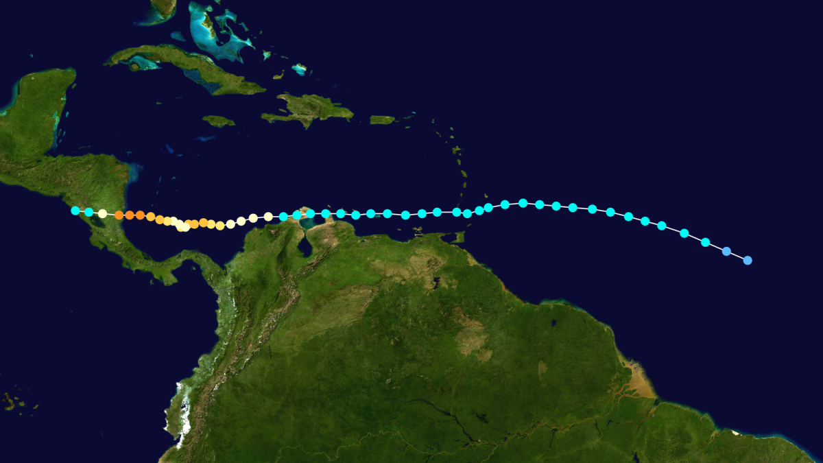
On this day, in 1988, a long-lived storm tore through the Caribbean and Central America in a due west direction over the span of two weeks. This hurricane was named Joan and reached category four levels of strength with peak winds reaching 143 miles per hour. Hundreds of lives were lost and billions of dollars of damage were reported. Check out the photo below showing the nearly perfect straight path that Joan took!

The track of Hurricane Joan!

That’ll do for today! Have a good one!

Posted in Kentucky Weather | Comments Off on Today in Weather History

Another Beautiful Day!

Good morning readers, and happy Wednesday!

Forecast

Looks to be another pleasant day in store for us, as we continue to feel the effects of slightly cooler air from the dominant high pressure system. Today you can expect temperatures in the mid 70’s with low humidity and some clouds. Into tonight, temperatures do not fall as low as they have the past couple of nights, with low temperatures around 60. Tomorrow brings us a rain chance, so make sure and stay tuned for that.

Weather Fact!

While it has been chilly the past couple mornings, we have yet to dip low enough to see our first frost of the fall season. The average date of our first frost here in Bowling Green is October 22nd. (Old Farmer’s Almanac)

Enjoy the beautiful weather, and have a great rest of your week 🙂

Posted in Kentucky Weather | Comments Off on Another Beautiful Day!

Hello, Sweater Weather!

Good evening, everyone! That seasonal trend of plentiful sunshine, low humidity, and cooler temperatures will carry on into tomorrow, but let’s take a look at what to expect.

If you’re an early riser, have a jacket ready to throw on before stepping outside, as temperatures will linger in the upper 40’s. As the sun rises, temperatures will as well, with our high reaching the mid-70’s. With low humidity, calm winds may feel slightly crisp, though clear skies will offer enough warmth to make for comfortable conditions. Into the night, temperatures will drop to the lower 60’s with isolated chances of showers taking place into the overnight hours.

Have a wonderful week!

Posted in Kentucky Weather | Comments Off on Hello, Sweater Weather!