It has been a beautiful start to the week! Warm temperatures and sunny skies made for quite a nice past few days. But here comes the rain again!
0Z NAMNEST Simulated Reflectivity: Now Until Early Saturday Morning0Z NAM Precipitation Type: Now Until Early Saturday Morning
With the pleasant weather as of late, tree pollen has been pretty high. For all those with pollen allergies, Thursday night will be a relief! Models (such as the ones posted above) are all in agreement with a pretty decent rain for this area Thursday evening into Friday early morning. A good night to sleep with the windows open!
0Z NAMNEST Surface Temps
Before the rain, Thursday will be warm again! We could see temperatures climb to the lower 70s before the rain arrives in the evening. However, as the model above is hinting at, cooler temperatures are expected for Friday following the rain.
There could be a chance for a few thunderstorms this weekend, so be sure to stay up to date with the latest from our blog!
Thursday: High of 71, Low of 50 and Rain in the Evening
Friday: High of 65, Low of 52 and Early AM Rain
Saturday: Clear and Warmer, Middle to Upper 70s Possible
Sunday: Chance for Thunderstorms?
Posted inKentucky Weather|Comments Off on Rain Chances on the Way!
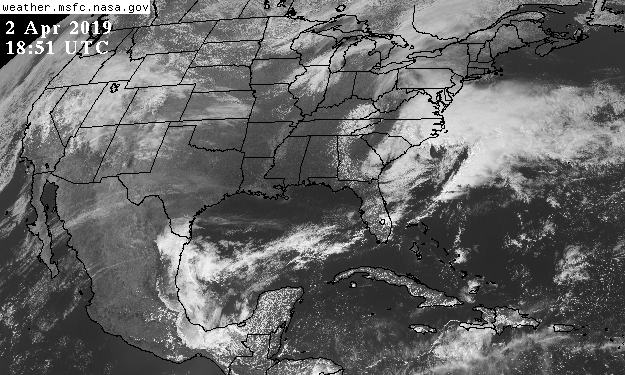
Good afternoon everyone! I hope you all are enjoying this gorgeous day as temperatures hit 60° and flowers are in bloom. Satellite imagery shows little to no clouds around the area.
Thankfully we still have tomorrow to enjoy the weather before a cold front moves in with rain and possible storms.
Rain will arrive for Thursday with the majority falling in the afternoon hours to Friday morning. Most of the models have a quarter to half an inch which looking at the data I would agree.
SUMMARY:
Tuesday:
High: 61
Low: 42
Wednesday:
High: 70
Low: 45
Thursday:
High: 68
Low: 54
Precipitation: 1/4 to 1/2 inch of rain with most of it falling in the afternoon and at night.
Stay safe and have a great week!
Posted inKentucky Weather|Comments Off on Spring Weather Will Turn Rainy Again
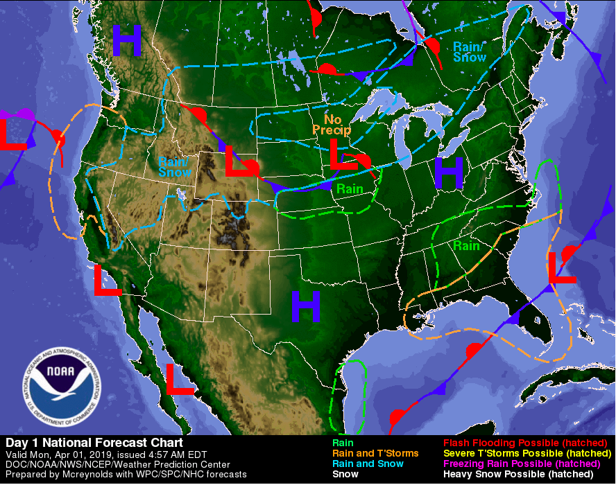
A cold front has moved through this past weekend bringing back much cooler temperatures. Fortunately, we will see temperatures back in the 70’s by mid week. We will also see lots of sunshine for the start of the work week, thanks to a high pressure system currently sitting on the northern KY/ Ohio state line. Plan for this high pressure system to move out relatively quick before another moves in from the south (currently located in Texas).
As for today, expect another chilly day filled with sunny skies. Tuesday we will warm a bit getting back into the lower 60’s. We will stay clear until mid week when the next low pressure system, bringing rain, makes its way back into our region. The only issues there could be moving into tomorrow is the formation of frost. As dew point readings are expected to be in the mid 30’s tonight and the low likely to be in the lower to mid 30’s, frost is possible. Remember to protect any plants/flowers that may be important to you.
FORECAST
Today (4/01): Mostly sunny and chilly High: 54 Low: 34 Tonight: Mostly clear with frost formation possible overnight
A strong cold front has passed, bringing us in the mid thirties this morning;nevertheless, it will be a beautiful Sunday. With a high pressure field centered over in Kansas, this will be ensured.
Surface Observations (Source: College of DuPage)
However, Sunday will not see spring-like temperatures this afternoon, for highs will only reach the mid 40’s. Lows for Sunday will be in the upper 20’s for it will be a clear night. Monday will see a continuation to the sunshine, with highs in the low 50’s, and lows in the mid 30’s, but it will get cloudier as the day progresses. Tuesday will have a cloudy start, but will see clearing for another sunny day. Highs for Tuesday will be in the mid-upper 50’s, and lows in the mid-thirties.
6Z GFS Average Cloud Cover (Source: College of DuPage)
Forecast:
Sunday: Sunny and cold; High: 48, Low: 27
Monday: Increasing cloudiness for the afternoon; High: 50, Low: 34
Tuesday: Clearing for the afternoon; High: 58, Low: 37
Posted inKentucky Weather|Comments Off on A Cold but Sunny Conclusion
We are heading into a wet weekend for the last few days of March. Thunderstorms are going to make a pass throughout the mid-South for our Saturday. The below surface map identifies a stationary boundary crossing Indiana and Illinois which can take off as the low pressure field in Michigan gains strength. Storms will mainly be in the afternoon hours as well.
Surface Observations (Source: College of DuPage)
These thunderstorms also have a chance of being severe when they arrive. However, Tennessee, Mississippi, and Alabama face a slight risk for severe weather. For us in Bowling Green, there is a marginal risk for severe weather. For more information regarding these risks, check out this website.
Day 1 Convective Outlook (Source: SPC)
As said before, storms will pass through in the afternoon and continue into the evening. Highs for today will be in the mid-upper 60’s, and lows in the lower 30’s.
11Z HRRR Simulated Reflectivity (Source: College of DuPage)
Once the cold front makes its pass through Kentucky, Sunday will be sunny, but noticeably colder, with highs in the upper 40’s, and lows in the upper 20’s. Monday will warm up slightly and continue the sunny trend, with highs in the upper 50’s, and lows in the lower 30’s.
Forecast:
Saturday: 100% chance for afternoon thunderstorms, High: 67, Low: 33
Those 70s across the region yesterday felt amazing! They also showed us that those spring-like temperatures are starting to show themselves (It’s about time!). Spring showers are on their way for the weekend but will not overstay their welcome. They will, however, help with our deficit of rain for the month just a tad at least.
Local Climate Report for Bowling Green, KY valid 03/28/19
Weekend Set-Up:
A frontal boundary to our north has stalled out across the OH Valley which allowed a couple of sprinkles to fall this afternoon. A low pressure will move into the Great Lakes region throughout the day tomorrow bringing more shower and thunderstorm chances for the early afternoon and evening hours. The instability ahead of the cold front looks good enough to support a line of strong to severe storms. The main threats associated with these storms are brief heavy rainfall, isolated damaging winds, and an isolated tornado is not out of the discussion. After the passage of the front, temperatures will dip into the mid-upper 40s for Sunday. Overnight lows Sunday will fall into the mid-upper 20s with a hard freeze in many areas possible. Make sure to take necessary precautions including covering up any outside plants that are exposed to the cold temperatures. There is good news regarding the temperatures, however, as we should see them start to recover over the upcoming workweek!
HRRR Simulated Reflectivity valid for 19Z (2pm) Sat 03/30/19.
NAM Simulated Reflectivity valid for 0Z (7pm) Sat 03/30/19.
36 hr Forecast:
Tonight: Isolated showers possible with lows bottoming out into the upper 50s. Wind out of the S at 9 mph.
Tomorrow: Showers and Thunderstorms Likely. Some storms could be strong to severe. Highs top out in the low 70s. Winds will be gusty out of the SW at 14-20 mph. Gusts could be as high as 31 mph.
Tomorrow Night: Showers and Thunderstorms ending before midnight. Lows will fall into the low 30s. Wind out the N at 11-18 mph.
Stay weather aware tomorrow by following these Social Media Accounts:
Taking a look at surface observations across the contiguous US, surface high pressure is currently centered over the southeast aiding in the calm conditions we had for today. Conditions will change as a center of low pressure that currently sits over the Panhandle of Oklahoma will move into the region. Surface convergence out ahead of the system will cause rain showers to move into the Ohio River Valley during the overnight hours. Those possible rain showers will have to overcome and battle against some relatively dry air that is in place. Rainfall totals will be on the lighter side during the overnight hours.
Might need the umbrella as you head out for your Friday morning commute as the area of low pressure with a cold front extending to it’s south, inches closer to our area. The rain chances will taper off heading into the afternoon hours, with highs rebounding back into the upper 60s to low 70s.
The surface low that is now sitting over the Panhandle of Oklahoma will move out of the eastern Plains and will hover around and ride along a stationary boundary as we head into Friday night. Model guidance are in agreement with this disturbance moving into the Great Lakes region on Saturday. As the disturbance moves north, the stationary boundary that it was initially riding along will phase into a warm front and move north, allowing SW flow to kick in and pull in moisture from the Gulf. This will help juice up the atmosphere a little bit.
Later in the day on Saturday, a cold associated with the area of low pressure will push through the area. Widespread rain with embedded thunderstorms are possible during the day ahead of the cold front. The main threats will be heavy rain, some cloud to ground lightning, and some gusty winds.
The cold front will move through the area during Saturday evening and rain chances will diminish immediately after it passes. Temperatures behind the front will drop quite drastically as a strong Canadian surface high pressure settles in with cold and dry NW flow settling into the area. Temperatures Sunday morning will drop into the 30s, might need to wear a coat as you head out for Sunday morning church services.
Tonight: Isolated showers after 5am. Increasing clouds, with a low around 55. South wind 6 to 9 mph.
Friday: Scattered showers, mainly before 2pm. Cloudy, with a high near 68. Light south wind increasing to 5 to 10 mph in the morning. Winds could gust as high as 20 mph.
Friday Night: A small chance of showers, mainly after 2am. Mostly cloudy, with a low around 56. South wind 7 to 9 mph.
Saturday: A chance of showers, then showers and possibly a thunderstorm after 8am. High near 67. Southwest wind 11 to 16 mph, with gusts as high as 26 mph. New rainfall amounts between a quarter and half of an inch possible.
Sunday: Mostly sunny, with a high near 49.
Posted inKentucky Weather|Comments Off on Rain Chances Return for the Weekend
I hope everyone is enjoying this gorgeous weather. That low pressure system that brought about all that rain has pushed off the east coast and in its place, a high pressure system has come in. With a high pressure system comes sunny, mild weather which will stick around for a few days.
A satellite view from before dawn this morning until this afternoon shows those clouds from yesterday being pushed out for today’s clear skies.
Our biggest chance for a new system comes Friday. More on that will come tomorrow. For the next three days though, enjoy the warm and sunny weather. Especially enjoy Thursday as temperatures could hit in the low 70s!
SUMMARY:
Tuesday:
High: 55
Low: 31
Wednesday:
High: 63
Low: 54
Thursday:
High: 71
Low: 48
Have a fun, safe week!
Posted inKentucky Weather|Comments Off on Warming Up for the Week
Last night a low pressure system moved through our region bringing with it the rain that occurred into early this morning. As for the rest of the day, expect mostly cloudy skies with a chance of some remnant showers extending down from our north. As seen below from RadarScope, the only showers are isolated to our south just east of Nashville.
RadarScope Super-Res Reflectivity
As for what we can expect the rest of the week, a high pressure system is making its way to the south and east eventually settling in the Great Lakes region. This will allow us some Spring time weather of sunny skies and “warm” temperatures. You can expect clouds to begin decreasing this afternoon and overnight leaving behind mostly sunny skies Tuesday. Temperatures will be a bit cooler Tuesday, as we have had the passage of a cold front. Luckily, temperatures will feel very pleasant by the end of the week with high’s to be in the 70’s Thursday and Friday.
NAM 12km Model 12z Run (Tropical Tidbits)
FORECAST
Today (3/25): Mostly cloudy with a chance of some remnant scattered showers High: 61 Low: 33 Tonight: Cloudy early with clouds decreasing overnight
Tuesday (3/26): Cooler but mostly sunny skies High: 56 Low: 31 Tuesday Night: Clear and chilly
Posted inKentucky Weather|Comments Off on Wet Start but Spring to Take Hold
14Z Surface Observations (Source: College of DuPage)
It may be clear now, but in the afternoon, a weak mid-latitude system will pass through Kentucky, bringing more rain for the mid-South. Highs for Bowling Green today will be in the lower 60’s, and lows will be in the lower 50’s.
12Z RAP Simulated Reflectivity (Source: College of DuPage)
Monday will see similar conditions to Sunday; however, there is a much higher chance for thunderstorms compared to Sunday. Highs will be in the upper 50’s, and lows will be in the upper 40’s. Monday afternoon will be more calmer as the storms will make a pass in the morning. Tuesday will be clearer, with highs in the upper 50’s and lows in the lower 30’s.
Forecast:
Sunday: 80% chance for rain in the afternoon, High: 60, Low: 50
Monday: Morning rain and thunderstorms, High: 57, Low: 49
Tuesday: Sunny, High: 59, Low: 33
Posted inKentucky Weather|Comments Off on Some Rain to End the Weekend