It’s that time of year again when WKU storm chasers set out on their annual adventure to forecast and document severe weather in the US Great Plains. Dr. Josh Durkee, associate professor of meteorology/geography, along with Dr. Grady Dixon, associate professor of meteorology and climatology from Mississippi State University will lead the group comprised of 8 WKU undergraduate/graduate students (see WKU News Story). This capstone meteorology course more formally known as “Field Methods in Weather Analysis and Forecasting” is comprised of both an in class portion of the course and two weeks of forecasting and storm chasing in the Great Plains. This year’s course kicked off this Monday with the classroom portion of the course. Throughout this past week students have practiced their forecasting skills by examining past severe weather events and they have been closely studying weather forecast models for the upcoming week.
The weather pattern for the majority of the year thus far has not been favorable for tornadoes, which has led to one of the least tornadic time periods in recorded history. The pattern appears to be changing however which will make severe convective storms more probable. The group has been analyzing the best possible day to begin the two week chase. The pattern setting up is bringing the risk of severe storms in the Great Plans by Saturday and continuing into early next week. This has allowed the group to either plan to start the chase Saturday or Sunday depending on the severe weather setup. The distance to reach the Great Plains requires a full day of travel to the Great Plains so the group must leave a full day before the first chase day. With that in mind we needed to decide to leave Friday to chase Saturday or leave Saturday to chase Sunday. While storms appear likely in both Kansas and southwest Nebraska on Saturday, ultimately the group has decided to wait to start the chase day on Sunday which looks to bring a better probability of severe weather along with a better tornado potential in an area from Iowa to Oklahoma. The chase looks to continue into early next week in the south-central Plains. These areas of interest are generally outlined by the Storm Prediction Center’s severe weather outlooks for Sunday (red) and Monday (purple).
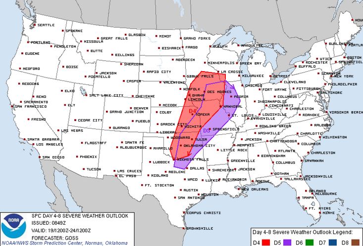
The SPC severe weather outlook for Sunday (red) and Monday (purple). These areas are generally where the group is targeting to start the trip.
Want to keep up with the action as we travel the plains in pursuit of severe weather? Here’s how to do so:
- We will be updating this blog with our daily chase summary of the previous day.
- On Twitter: ttps://twitter.com/wkustormchase
- And also on Facebook: https://www.facebook.com/wkumetclimsci