Showers and storms set to impact the area tonight…

Warmer conditions have flooded much of the region for the past couple of days as highs have gradually warmed into the low to mid 70’s across the area.  Mostly sunny conditions have ruled the skies for Wednesday as those fall time colors have began to really show across the area.  We wrapped up the weekend on a wet and windy note as a system worked its way though the region bringing showers and very windy conditions.  The front eventually tracked its way through the state and pushed eastward as a ridge of high pressure begin to build over Central Plains and into the Ohio Valley by Monday.  In return, pleasant and cooler conditions returned to the Bluegrass to kick off the week.

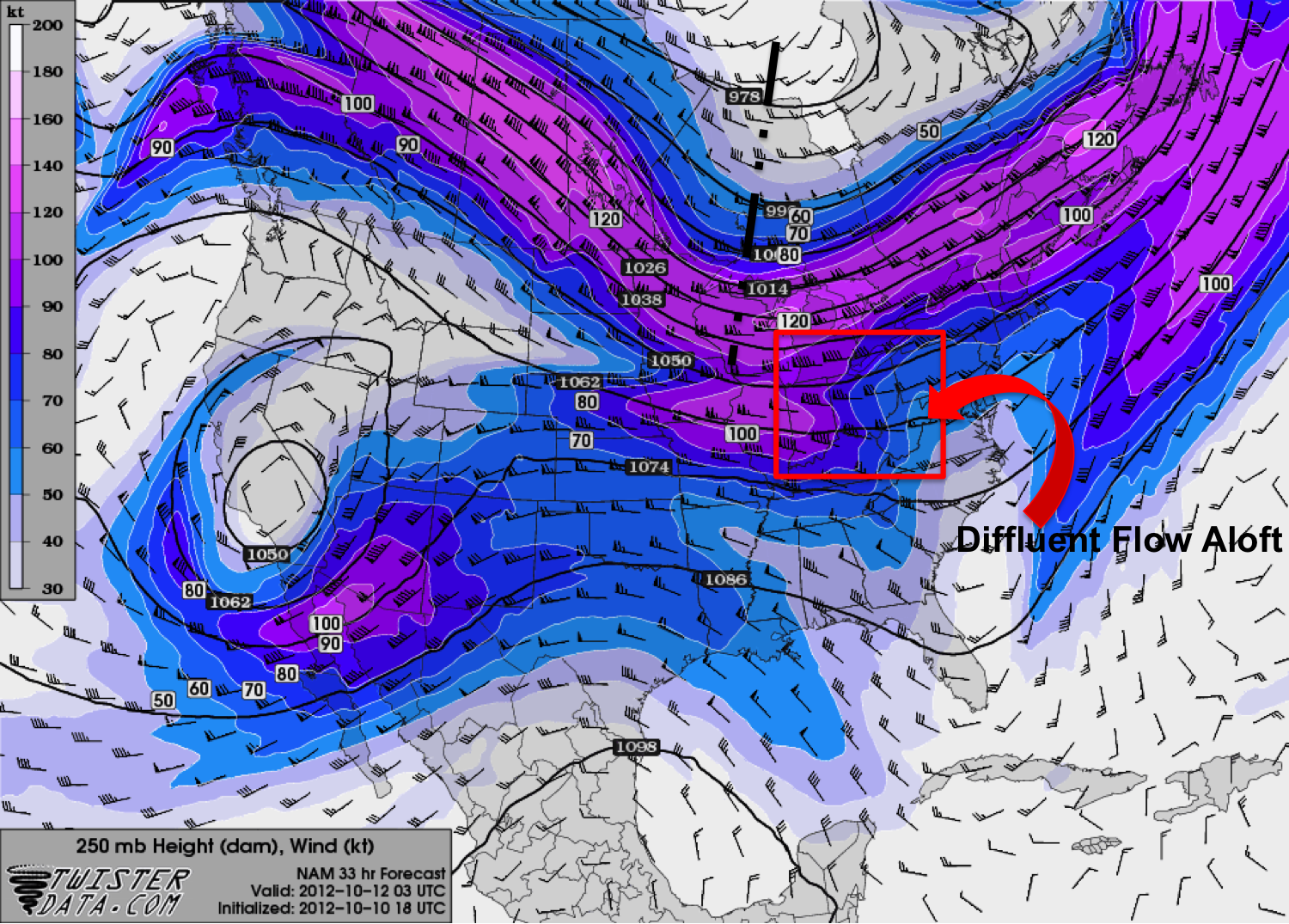
We now turn our attention towards a similar set up that we had this past Sunday.  The 250 mb heights and winds map shows an upper level cut-off trough slowly tracking eastward over the Dakota’s.  Jet streaks have been very strong with upper level winds reaching 100-120 knots over parts of the Central Plains as the trough continues to dig.

250 mb Heights and Winds map valid for 06Z Thursday.

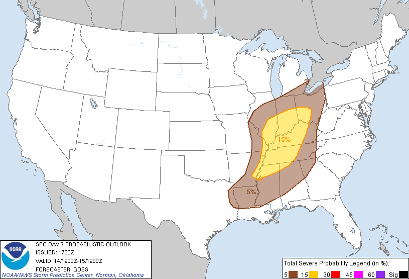
The trough will continue its progression eastward and in return drape a cold front from parts of Minnesota down into Missouri and Oklahoma.  Similar to the last set up we had on Sunday, the lack of instability seems to be the main problem with the development of widespread severe storms.  Surface-500 mb bulk shear map shows strong mid-level winds over the Central Plains ranging from 50-80 knots.  At 700mb the atmosphere continues to show a saturated upper level which is important for the development of these showers and storms.  Surface dewpoints lack a bit but range from 50-60 degrees as precipitable water values range from 1.1-1.5 inches over parts of western and south-central KY.  The SPC’s latest outlook outlines the possibility for severe weather over parts of the Central Plains as those areas are under a SLIGHT risk for severe storms this evening.  The risk also includes far Western Ky counties as well as the line of showers and storms could potentially affect those areas as the front continues to slide eastward.

Storms that do develop over parts of Missouri, Arkansas, and Louisiana will develop and track eastward ahead of the front. With the lack of instability over our area, the storms are expected to weaken considerably as they approach lesser amounts of instability.  Nonetheless, given the strong wind fields aloft, some of the convection overnight could pose a wind threat as these storms may be able to transfer some of that higher momentum air down to the surface.  These storms will have a decent amount of moisture to work with as QPF amounts range from 0.5-1.0 inches for the area.  In addition to the showers and storms, the pressure gradient will tighten up over the region bringing south to southwest winds across the area around 15-25 mph with gust up to 35-40 mph. The latest HPC forecast gives a good idea of precipitation amounts expected.

Latest HPC map showing widespread rainfall amounts across the area.

As the system tracks through the Ohio Valley region later tonight, expect mainly windy conditions with light to moderate rain over the area.  Expect lows to drop down in the low 50’s under cloudy skies as the chance for showers will loom later tonight and into your Thursday morning.  Look for partly cloudy skies across the area with highs struggling to hit the mid 60’s.  Clouds look to hang tough heading into Thursday evening as lows drop into the low to mid 40’s with light winds from the south.  By Friday, look for dry conditions to prevail as partly sunny skies are expected.  Highs will be a tad cooler as temperatures struggle to reach the mid 60’s with winds from the southwest around 10-20 mph.


Posted in Uncategorized | Comments Off on Showers and storms set to impact the area tonight…

Stormy weather set to move in…

Saturday kicked off the weekend on a relatively nice note.  A cool morning eventually led to partly sunny skies and slightly warmer conditions across the region.  Highs across the area quickly warmed up after a chilly start as temperatures topped out in the mid to upper 70’s statewide.  A warm front moving through the region brought somewhat of a change back to above normal conditions after much of the week offered cooler than average temperatures.  This noticeable change will come behind gusty southerly winds as high pressure begins to shift towards the Atlantic and low pressure develops across the Central Plains.

HPC/NOAA Current Surface Analysis

Current surface analysis shows the development of the low over the Central Plains with the cold front extending into parts of the Oklahoma/Texas panhandle.  The warm front stretches from parts of South Dakota over to Ohio and in return has continued to advect the warmer air over the region.  Heading into the evening and overnight hours, the current set up will allow for a milder low than we’ve seen lately. Low’s are expected to bottom out around the 60 degree mark for Bowling Green, as other areas across the state will see temperatures drop into the upper 50’s under mostly cloudy skies. Pressure gradients will tighten up overnight bringing very windy conditions across the area. Expect sustained winds around 15-25 mph with the possibility of winds gusting up to 40+ mph.

Looking ahead for your Sunday, a cold front will move across the Ohio Valley region Sunday afternoon/evening.  Ahead of this front, expect a line of showers and storms to develop in the warm sector.  Surface-500mb bulk shear winds showing strong values ranging 40-50 knots leading to the possibility of decent development of storms.

Surface-500mb Bulk Shear Map valid for 18Z Sunday. Areas over the Ohio Valley region showing strong wind values ranging from 40-50 knots.

Instability over the area will remain the key factor in the development of any strong to severe storms.  CAPE values continue to lack but still look to provide enough energy with values ranging from 750-1300 J/Kg.  Southerly flow will allow temperatures to warm in the mid to upper 70’s as dew points climb into the mid 60’s.  Precipitable water amounts range from about 1.4-1.8 inches statewide with relative humidity values reaching greater than 70%.  The latest SPC forecast shows some agreement as the forecast shows s SLIGHT risk for much of the state for Sunday.

SPC Categorical Outlook for Sunday. Showing a SLIGHT risk for severe storms across the Commonwealth.

The low will continue to track towards the northeast into northern Illinois and eventually over the Great Lakes region by Sunday night.  The cold front will slide through the area bringing a slight risk of storms with the main threat of heavy rain, gusty winds, and the possibility of hail.  As far as the amount of precipitation expected with these storms, the HPC seems to think a decent rainfall will occur. Areas just to our west could receive a decent amount of rainfall ranging from 1-2 inches, with higher amounts to the north.

HPC’s QPF map showing a decent rainfall for the Central Plains area extending northward into the Great Lakes region.

The front should arrive by the late afternoon/evening hours and will continue to track eastward across the state.  Rain should move out of the area overnight Sunday night with cooler temperatures filtering in from the northwest.  Expect lows in the mid-50’s with clearing skies and light northwest winds around 5-10 mph.


—————————

Outlook:

Monday: Mostly sunny…High: 67.  Northwest winds 5-10 mph.

Monday Night: Patchy fog after 4am. Otherwise, mostly clear…Low: 44. Light and variable winds.

Tuesday: Mostly sunny…High: 68. Light and variable winds.

Tuesday Night: Partly Cloudy….Low:49. Southwest winds around 5 mph.


Posted in Uncategorized | Comments Off on Stormy weather set to move in…

Weekend Severe Weather Threat and Forecast

Moving into the weekend, we will see a strong shortwave trough continue to advance east over our area. This disturbance will have weakened somewhat upon arrival but will still allow for the development of severe weather across Western Kentucky.


The lacking factor in this set up will be instability. CAPE parameters are lacking looking through the day Sunday with values less than 750 j/kg^1.  This is likely due to forecast overcast skies Sunday that will inhibit any daytime heating and air mass destabilization. With this in mind, we are looking at a linear squall line even for Western Kentucky with the biggest threats being damaging winds and hail though an isolated squall line tornado is not out of the question. The Storm Prediction Center has placed Bowling Green in the slight risk for Sunday. Taking a look at the probabilistic  outlook, we see Bowling Green in a 15% chance for severe storms Sunday.


A strengthening pressure gradient out ahead of the system will contribute to a strong low level jet and gusty Sunday. A high wind advisory may need to be issued into the day Sunday. Temperatures will take a dip after the passage of the cold front Sunday night with surface ridging building in behind.


Sunday Forecast Overview:

High, 75. Low, 56. Gusty winds throughout the day with thunderstorm development in the late afternoon. Main threats high wind and hail. Storm to continue into the night with rain ending in the early hours Monday morning.

Posted in Uncategorized | Comments Off on Weekend Severe Weather Threat and Forecast

End of the Week Forecast and Preview into Weekend

We have experienced a cool week here in Warren County with frost advisory most mornings and cools starts to the day. Tonight a Freeze Advisory has been issued by the NWS in Louisville valid until 8 am CDT tomorrow. Tonight, we will have clear skies over the area allowing the temperature to drop lower than previous forecast lows. Overnight, an area of high pressure with slide over the area and move out to the east into Thursday. This will keep our skies mostly clear and morning lows low.

 Our next chance for showers and thunderstorms will come Thursday night as another trough axis swings through the upper levels. A merging/splitting pattern of the polar jet and subtropical jet will provide enhanced difluent flow aloft which will provide some upper level support for thunderstorm development. Moisture will again be somewhat limited with northerly winds advecting dry air from a cold air mass over the great lakes and Dakotas over our area. A warm front will move north from the south west and cause and increase in clouds by Thursday night. This will allow us to warm temperatures a few degrees as the warm front passes Friday-Saturday and winds shift from the north west to the south east gradually into Thursday night.

Looking into the weekend, we see a powerful system develop off the west in the form of a cut off low that develops off the west coast and slowly wobbles our way with fast moving winds circulating through it at the 500 mb and 250 mb levels. This system will drag over the Rockies and develop an associated surface low as it passes over the mountains and into the lower plains. As this system progresses, the low will be reabsorbed into the polar jet flow Saturday night into Sunday as it progresses towards our area. The next forecast update will detail the expectations for this system further.


Forecast Overview:

Thursday: High, 65. Low, 50. Clouds increasing into the night as another weather system moves in. 30% chance of showers and thunderstorms Thursday night.

Friday: High, 70. Low, 50. Left over precipitation will move out with temps warming back up.

Posted in Uncategorized | Comments Off on End of the Week Forecast and Preview into Weekend

Weekend Weather Wrap Up and Forecast 10/8-10/10

Temperatures are beginning to become more fall like after a strong cold front and canadian air mass moved through Kentucky over the weekend. Surface high pressure has built in behind with winds remaining out of the north allowing the colder temperatures to continue to be advected into Kentucky.


Another area of low pressure has begun to develop over the Canadian border. A trough continues to deepen to the west over the Canadian border and propagate to the east into the week brining more cold temperatures and chance of showers by Tuesday night as another cold front develops and moves east over Kentucky. As with the last Canadian air mass, this one will also be dry which will inhibit precipitation chances. Both NAM and GFS models paint a line of precipitation moving through Wednesday ahead of the front. With a tight band of moisture out ahead of the front, this looks bleak. A few stray showers/sprinkles cannot be ruled out Tuesday night into Wednesday. Frost advisories are likely to remain into the week as cold overnight lows and dew points in the 30’s combine.

Forecast Overview:
Monday 10/8: High, 62. Low, 39 . 10% chance of precipitation, morning frost likely. Winds chilly out of the north.

Tuesday 10/9: High, 68. Low, 43. 20% chance of precipitation, morning frost likely. Front approaching overnight Tuesday with colder temperatures filtering in behind. Winds will remain northerly.

Wednesday 10/10: High, 63. Low, 39 . Front passes through with colder temperatures in behind. Morning frost likely. Temperatures drop further with passage of front. Winds chilly and out of the north.

FORECASTER: Emily Yates
NEXT UPDATE: 8/10/12

Posted in Uncategorized | Comments Off on Weekend Weather Wrap Up and Forecast 10/8-10/10

More Rain Chances Followed by a Dry Weekend

While areas from Paducah to Louisville have received several rounds of rain this week, south central Kentucky has stayed relatively dry.  A slow moving surface front has been located through the Ohio River Valley with several rounds of showers and storms moving along the front.  Some location in Kentucky picked up 2 to 3 inches of rain in the last 3 days, while others picked up very little if any at all.

3 Day Rainfall Totals:

Meade County Mesonet (near Brandenburg)- 3.71 inches
Fulton County Mesonet (near Hickman)- 2.20 inches
Louisville Bowman Field- 1.57 inches
Bowling Green/Warren Co Regional- 0.15 inches
Allen County Mesonet (near Scottsville)- 0.00 inches

As of this morning (Thursday) the front responsible for this rainfall extended from the mid-Atlantic states, through the Ohio River Valley and down to Oklahoma.  This front will finally be getting a push to the south today however, which will bring better rain chances for southern KY today through midday Friday, before the front pushes south of the state.  Rainfall amounts should generally be light with totals ranging between 0.1 and 0.5 inch.

HPC forecast surface map for Friday. The front will be pushing south of Kentucky and thus bringing any rainfall to an end.

Behind the front, a trough will deepen into the area which will bring a return to cooler temperatures.  An upper-level low centered over the Great Lakes associated with the trough will bring some clouds in for Saturday and a light shower can’t be ruled out early.  This trough will continue to spin over the Great Lakes into Sunday before pulling out by Monday.  Overall however the weather should make for a nice early fall weekend with temperatures in the mid 70s for highs while lows will return to the low 50s.  Our next weather maker looks to be in the form of a cold front which will impact us on Tuesday.

Daily Forecasts:

Thursday: 60% chance rain and thunderstorms, especially into the evening, with a high near 78.  Winds will be from 5-10 mph switching from the southwest to the west-northwest.

Friday: 40% chance of rain coming to an end by the afternoon.  Morning lows will be around 61 and afternoon highs will be near 74.  Winds will be out of the west to northwest from 3-7 mph.

Saturday: Mostly cloudy skies will become partly cloudy with a stray shower possible.  Temperatures will be cooler with a low around 52 and a day time high around 74.  Winds will be from north between 4-8 mph.

Sunday: Mostly sunny skies with a low near 50 and a high around 75.

Posted in Uncategorized | Comments Off on More Rain Chances Followed by a Dry Weekend

Cold Start to a Gorgeous Day, Rain Chances This Week?

The first weekend of fall brought with it fall like weather.  Saturday and Sunday brought beautifully sunny skies with temperatures falling from high near 80 on Saturday to a high of only 68 on Sunday behind the cold front.  Overnight lows took a dive as well falling to 37 this morning at the Warren Co mesonet site as a result of clear skies and calm winds.  Temperatures will be rebounding throughout the first part of this week however.  The trough that has brought the cool temperatures will be retreating to the north which will allow temperatures to begin warming back up throughout the week.  After a very nice day in the low 70s today, 80s will return to south-central Kentucky for highs by Tuesday.

Tuesday Surface NAM

The NAM surface pressure/winds/temperature forecast for 4 pm Tuesday with analyzed fronts. Green arrows indicate moist air coming to the Ohio Valley from the Gulf of Mexico.

The high pressure system that is currently centered directly over Kentucky will be sliding southeastward.  The position of the high pressure system by Tuesday and a weak cold front from the Great Lakes to the Midwest will create a strong low-level jet which will bring in warm moist air from the Gulf of Mexico.  Winds could be quite blustery Tuesday, blowing out of the south-southwest from 15 to 20 mph.  As far as any precipitation is concerned, forecast models generally agree that an axis of rainfall will setup just to the south of the cold front.  For us here in southern Kentucky current thinking is that heaviest of the rainfall will remain along and north of the Ohio River.  Still yet, increased clouds and the chance of rain does enter the forecast for Tuesday and Wednesday.  Our best chance of rain comes Wednesday afternoon as the washed out front comes ever closer.

QPF Forecast

The Hydrometeorological Prediction Center’s 1-3 Day QPF or quantitative precipitation forecast.

A glance into the late week pattern reveals more of an east-to-west flow which generally spells quite weather for our area; however, a few small disturbances may pass just to our north which will mean slight rain chances through late week.

Daily Forecast:

Monday: Another gorgeous sunny fall day with temperatures warming to a high near 73.  Light southeast to southerly winds from 3 to 8 mph.

Tuesday: After a morning low around 54 temperatures will warm to a high near 83.  Skies will be partly to mostly cloudy at times with a 30% chance of rain.  Winds will be blustery out of the south-southwest from 15 to 20 mph.

Wednesday: Partly cloudy skies early becoming mostly cloudy in the afternoon with a 40% chance of rain.  Lows will be near 63 with an afternoon high around 85.  Southwest winds from 8 to 14 mph.

Thursday: A 20% chance of a shower in the morning before giving way to a partly cloudy day.  Low near 64 and a high around 84.

Posted in Uncategorized | Comments Off on Cold Start to a Gorgeous Day, Rain Chances This Week?

A Cold Blast to Finish Out the Week

The surface high pressure system that entered the area yesterday has mostly migrated to the New England states, but is still exhibiting control over our area into the lower Mississippi River valley. A cold front is extending from a surface low pressure center situated just north of Minnesota. The front extends with a SW orientation from Michigan’s Upper Peninsula into central Kansas. Overall, the upper level support is not very prevalent. For one, the 300mb trough has a neutral orientation with the jet max misaligned to the south of the center of surface low pressure. This will inhibit intensification and forward movement of the weather system. Also, there appears to be little positive vorticity advection, which in abundance stimulates lift and support for the surface low and front. The surface high pressure is important because it is preventing any chance of significant moisture advection into our area ahead of the cold front.

Above is the NWS Storm Prediction Center’s Short Range Ensemble Forecast Model valid for 7 AM this Saturday. It is showing probabilities for precipitation of .01 inches during a three hour span. Percentage values are almost nonexistent for our area.

Into Sunday, the upper level trough is shown to remain in its neutral orientation and deepening with the presence of a jet streak. As the jet max goes around the bottom of the trough, it will begin to shallow it out and move it eastward at the start of next week. The surface cold front presently draped across the midwest will likely fizzle out into Friday because of the stationary high pressure and lack of upper level support. The residual high pressure will resume control until being swept out by a cold front on Saturday. This front bearing low will have more support from the jet stream with the cold front looking to impact our area on Saturday afternoon. Because of the high pressure over our the region, the availability of moisture will be a concern and will determine the severity and even occurrence of precipitation associated with the frontal passage. Warm air advection will also be inhibited, which will put in question the strength of the front because of the diminished temperature gradient. Models are currently behind these assumptions with almost no indication of measurable precipitation associated with the frontal passage. With it being three days out, there is still room for error. Behind the front into Sunday, expect cooler temperatures again with a high pressure settling into the region.

Days at a glance:

Thursday: High 75 Low 48

Friday:      High 81 Low 54

Saturday:  High 77 Low 52

Sunday:     High 67 Low 37

Posted in Uncategorized | Comments Off on A Cold Blast to Finish Out the Week

Tuesday Cold Front to Bring A Taste of Fall

Currently, we are situated in the southerly, return flow of an eastward tracking surface high pressure system. There is also a center of surface low pressure in the Gulf of Mexico due south of Louisiana pumping moist, Gulf air straight north into our area. This is creating moderate values of moisture for the lower Mississippi and lower Ohio River valleys. A significant short wave situated in the lower Mississippi River valley is aiding in the moisture advection and providing lift, giving us the current showers. Periods of rain today are more widespread and prolonged, with less severe implications. To our west exists a cold front extending from Michigan’s Upper Peninsula with a southwest orientation across Iowa and into the Texas panhandle, with the center of low pressure in the northern extent of Quebec.

This is the Hydrometeorological Prediction Center’s qualitative precipitation forecast for today into tomorrow morning.

Models are depicting the upper level support for the front to increase as the 250mb trough over the upper Midwest is deepening positively with a jet max on the down stream side over the Great Lakes. This, coupled with increasing vorticity and vertical velocity values extending at the surface frontal vicinity will help to provide substantial support for the front. Moisture advection from the Gulf is shown to continue before the expected frontal passage shown by both the NAM and GFS models as early Tuesday morning around 7 AM.  Moderate to heavy rain and strong winds should be presumed as the main threat for the frontal passage. Periods of rain related to the front should be relatively brief, but intense. Models are showing a majority of the precipitation to be experienced to our east in eastern Kentucky and central Tennessee along the Cumberland Plateau with high probabilities of 3-hour accumulations around a quarter of an inch for the period of the next day.  The HPC’s forecast for precipitation accumulations agree with the models showing over 4 inches for the same geographic area through tomorrow morning. I think this is a little exaggerated depending on the speed of the cold front and will keep precipitation amounts lower for our area. We are also along the projected precipitation gradient, so precipitation amounts for our area look to be one inch to an inch and a half in total. A flood watch has been issued for areas to our east because of the duo of soaking rains today with the frontal passage tomorrow morning. Behind the front, dry, cool air will look to bring a hint of fall as a surface high pressure situates over the area. A light jacket will be advisable.

Days at a glance:

Today:         High 74     Low 65

Tomorrow:  High 70     Low 44

Wednesday: High 67     Low 40


Posted in Uncategorized | Comments Off on Tuesday Cold Front to Bring A Taste of Fall

Clouds to stick around….isolated chance for showers.

The weekend kicked off fairly nice across the area with partly to mostly cloudy conditions for much of your Saturday.  The ridge that hovered over the Ohio Valley region much of the week moved into the New England region and is now situated well off the eastern coast.  A weak, but dry front tracked through the area by Friday morning bringing a few isolated showers across parts of the state.  In behind the front cooler and drier air filtered in throughout the state bringing pleasant conditions for many.  Temperatures on Saturday struggled to hit the 80 degree mark as most of the area dealt with partly to mostly cloudy skies.

As we head into the overnight hours, generally calm conditions should be expected as high pressure and light northwest winds will keep drier, cooler air over the area.  Saturday nights lows will be chilly with temperatures expected to drop into the upper 50’s as clouds will continue to thicken through the overnight hours.

850 mb showing heights and cloud cover valid for Sunday 13z. By Sunday morning, as mentioned above, clouds will thicken and continue to hang tough around our area. Much of the state should see partly to mostly cloudy conditions. Image produced by IDV.

The light rains currently over southern Missouri will weaken pretty quickly as they move southeast across western Kentucky during the early morning hours.  Sunday morning will bring mostly cloudy skies with an isolated chance for a shower, especially across parts of Southwestern KY.  Highs for your Sunday will be very comfortable with temperatures reaching 77 degrees.


Posted in Uncategorized | Comments Off on Clouds to stick around….isolated chance for showers.