adding flurry chance today


With steep lapse rates and a disturbance moving through the chance for some snow showers and flurries is present. Radar trends show some of this activity moving toward the BG region as lift form the disturbance coupled with some instability has lead to development of flurries across the region no accumulations are expected.

Posted in Uncategorized | Comments Off on adding flurry chance today

Colder start to 2012


Happy New year to all!

1. I want to touch up mainly on the impacts of Sunday’s front plus a look a quick shot of winter for the region early next week.

2. Back to the last forecast feel good overall that a comparison of forecast highs Friday here was dead on while the NWS and many other forecasts were to cool back when the forecast for a high of 60 Friday was made. Hopefully we at WKU can keep up the good work!

3. A frontal boundary will move the region Sunday with an increase in clouds overnight to end 2011 as well as a nice surge of warm air advection to keep temperatures in the 40’s overnight.

4. Cold air advection behind the front will make it hard for temperatures to reach 50 Sunday before falling in the afternoon back into the 40’s. A passing shower can’t be ruled out as well.  Winds will increase as well from 15-25 mph with gusts up to 35 mph.

5. Monday the flow will be out of the northwest with winds of 20-25 mph and higher gusts. We would need a northerly flow Monday night for some snow shower activity with enhanced fetch off Lake Michigan. As it stands on the bluegrass, northern and Eastern KY have a shot at a few snow showers while BG remains dry perhaps a mostly cloudy sky for a while Monday night due to the passage of a vort max. I’m going with highs in the mid 30’s Monday which agrees with guidance after starting out near 30. Not sure what up with forecasts having highs near 40 Monday.

6. Tuesday should have a chilly start with lows near 20 and highs near 30 winds will be lighter only in the 5-10 mph range.

Posted in Uncategorized | 1 Comment

Forecast for rest of week

To recap Tuesday:

– the low cut further northwest but just slightly this allowed a wedge of WAA for a few hours to be located farther west over BG thus the temeprature rose to 46 instead of the low 40’s. This made all the difference on the back edge of the precipitation instead of mid 30’s has upper 30’s.

Forecast:

Highlights

– Week clipper systems passing to our north 

– Overall still very mild

– Several windy days as well 

Forecast: 

A week clipper system will track across the great lakes Thursday, with it a warmer airmass will move into the region along with a mix of sun and clouds. High temperatures Thursday after a chilly start should rise to 53-58. A stray sprinkle or light shower cannot be ruled out either. Another week clipper system will move to the north of the region once again on Friday bringing with it another surge of warm air. Lows will be in the 40-45 range with highs getting close to 60. This is several degrees above model guidance but usually model guidance is usually to cool in these set-ups. A concern would be if the clipper track was farther south which would increase the chances for passing rain showers and lower high temperatures Friday. Current thinking however only has a passing shower Friday, similar to Thursday with a track farther to the north. On both days winds will be gusty as well from 13-19 mph with gusts to 30 mph at times. On Saturday once again we’ll have a mix of sun and clouds with highs from 52-57 after starting out in the 35-40 range, winds will be lighter. For New Years day a strong frontal boundary is likely to move through the region. Timing of this boundary is still not entirely certain at this time which will have a large impact on temperatures. Right now the front should pass through the region in the afternoon. So this means clouds and warm air advection should increase with a chance for rain showers ahead of the front. Overnight temperatures New Years Eve should stay in the 40’s with highs reaching the low 50’s Sunday before falling rapidly by late afternoon. This leads to a likely cold start for the New Year however now no signs of the first measurable snow of the winter season are in the forecast. The pattern does not appear favorable anytime soon as we approach the halfway mark of meteorological winter. The winter of 1931-32 was snowless with several others having a trace for the entire winter. As it stands now a trace has fallen this season which would be the second least snowiest winter on record, quite a reversal from last year. 


Discussion:

– I’ve gotten burned with temperatures on the warm end of clippers many times in the past. It will be warmer than guidance. Unless the euro track is correct this would provide more clouds and rain. Models have a poor handle of advection.  

– Temperature spread was large within the guidance generally went warm with the clippers and ahead of Sunday’s front.

– Good agreement on gusty winds over the next several days except Saturday.

– I’ll update Sunday’s front more later this week along with a January forecast.  


Posted in Uncategorized | Comments Off on Forecast for rest of week

WIll rain change to snow Tuesday?

Here is a forecast overview

Highlights
– rainy morning perhaps ending as snow around lunchtime
– no hazards expected from snow chance
– high pressure and sunny skies return Wednesday

Forecast: A storm system which has been slowly moving across the
southern United States will lift northward into the Tennessee valley
before moving east into the mid-Atlantic states. An abundant amount of
lift and moisture will be drawn ahead of this system to provide
periods of rain from Monday night into Tuesday this will also keep
temperatures rather steady in the lower 40’s Tuesday morning. However
colder air will move into the region behind the main period of rain. A
secondary area of lift will move into the region around lunchtime
leading to another period of precipitation. As precipitation falls
with the second region of lift cooler air will be transported from the
upper levels leading to falling temperatures to mid 30’s for a time
early Tuesday afternoon. There is a good chance this secondary area of
precipitation ends as snow for a few hours early Tuesday afternoon.
The good news for most is that ground temperatures are very warm, even
if snow occurs hazardous roadways should not develop as temperatures
will stay above freezing the entire day and even rise back to around
40 after the precipitation ends by mid-afternoon Tuesday. Any snow
accumulation will be confined to grass and be under 1/2 inch where and
if snow does occur. Winds will also be gusty on the order of 13-19 mph
with higher gusts to 25 mph due to this system. It will feel more like
winter Tuesday. Skies will clear Tuesday nigh as high pressure
allowing temperatures to fall into the mid and upper 20’s with highs
Wednesday in the 40’s with mostly sunny skies. Winds will be lighter Wednesday from 5-10 mph. Updates will be
provided if the snow chance for Tomorrow looks to provide a more
substantial threat than indicated in this forecast.

MWG

I’ll go into more detail about it here.

– I talk about lift several times in this discussion. One source of lift with the main period of rainfall overnight and early Tuesday once again is isentropic. With the last system you recall the rainfall forecast was slightly overdone. This was due to thunderstorms over the south robbing the region of moisture coming our way. Once again mixing ratios are around 5 g/kg which would indicate around an inch of rain though once again convection to our southeast which shows well on SPC WRF could keep rainfall amounts around the 3/4 inch range, though the SPC WRF shows more rain, modeling always shows to much precipitation. Experience says go lower!

– low pressure is classic with a warm conveyor belt passing over the region Tonight and Tuesday morning with the region dry slotted for a few hours late Tuesday Morning then in the cold conveyor belt Tuesday afternoon

– Around 12z Wednesday modeling is indicating a secondary region of 700 mb  enhanced Omega over Western Kentucky coupled with forcing/lift due to the temperature contrast known as frontogensis. This should get banded or a band of precipitation on the backside of the system. This area of precipitation should track northeast into northern Kentucky through the afternoon. However the BG region should get some of the action.

– The cooling processes mentioned for the banded backside precipitation is known as dynamical cooling where precipitation falls to cool the atmosphere. Right now I think this should occur allowing the temperatures to fall into the mid 30’s during the time when the secondary precipitation region is moving through. Thus the chance Bowling Green does have snow for a time around noon Tuesday.

– After the precipitation ends however temperatures should rise a degree or two closer to 40 thus even if does snow during the small window any accumulation on a very warm ground will melt and roads will remain well above freezing and wet. Any accumulation stays under 1/2 inch.

– In terms of guidance agreed with elements of the SPC-WRF though a few hrs slow, the 12z NAM/ECMWF runs as well looked good. GFS had a poor time capturing the mesoscale features as was not used. Overall went with raw NAM/ECMWF guidance on temperatures and went a little higher than all guidance for winds Tuesday.

MWG

Long range: Euro weekly model appears to be wrong for next week. Modeling operational ECMWF, CMC and JMA  show a deep trough over the region for the middle part of next week this would not equal warmer than normal weather and in fact could bring more chill  and snow chances.  If you follow the 4th most accurate model the GFS it will come around to that hopefully sooner than later.

Posted in Uncategorized | Comments Off on WIll rain change to snow Tuesday?

Short term: Mr.Grinch controls the holiday weather

We’re continuing with a lack of cold air over the next several days. It now looks like some energy will move across the south but to progressive for a major system Christmas day. I think the ECMWF keeps to much energy trapped over the southern plains in bringing out another storm Tuesday.

-Tonight winds will still remain around 5 mph from the northwest. Clouds will be slow to clear out I suspect however the wind will limit fog overnight to a patchy nature. Some drizzle may be possible as well.  Temperatures should be steady in the low to mid 40′s Friday.

– Once again I’m going in the direction of the NAM and ECMWF for temps Saturday and away from the MEX guidance which has been to cool in recent days. Highs should be in the upper 40′s with lows near 30.  Skies will be mostly sunny.

– highs in the upper 40′s on avg. Lows should be near 30. With mostly sunny skies Christmas day.

Update- System looks to stay over the southern plains instead of coming out in pieces this means a dry christmas day with rain from Monday afternoon Through Tuesday. For snow St.Louis to Indy may see a few inches with colder air coming into the system Tuesday morning.

MWG

Posted in Uncategorized | 1 Comment

Long term: update on ECMWF weekly model and stratospheric warming effects

Thoughts on the control run of the euro monthly run forecast

– Most of cold stays locked up in Canada through Jan 15th

– Pacific flow across United states with ridge building over southern plains and east

– Pattern of transient  cool shots will continue. Number of mild days will outnumber cool days by a lot. in fact may see record warmth with severe threats

– No real signs of blocking over the pole regions

– cold begins intrusion into the northern plains around the 15th, large temperature clash across the plains, Ohio valley and great lakes from the 15th-25th with storm threats tracking to our northwest. Perhaps we get a favorable track for wintry weather toward the end of that period.

Some good news for actually seeing winter….

Stratospheric warming is still expected throughout the final week of this month. This again usually leads to a more favorable AO state about 3 weeks later. ( It has been positive this year which equals a mild pattern, last December it was negative thus the cold).
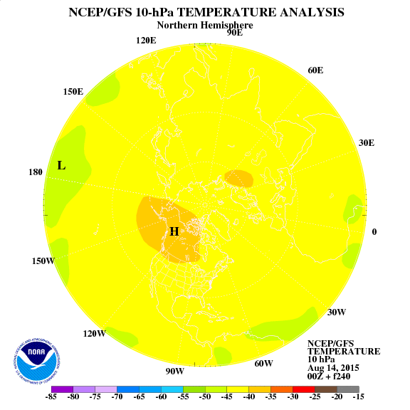
This configuration of the stratosphere may result in a majority of dislodged cold from the poles going into Asia but i still feel this will be a pattern changer after the 15th of Jan.

For now my overall thoughts on the pattern through the end of jan

Jan 1st through 8th- split flow patterns continues with mild weather across our region and periods of  rainy weather. Not buying into the GFS forecast of a -AO.

Jan 8th-15th Warm with a stronger southeast ridge severe weather and record warmth possible. Cold beginning to build over Rockies and northern plains.

Jan 15th-25th Stormy, large temperature spread with very cold conditions Rockies, northern plains. Very warm over southeast US. transition for us to normal wintertime weather.

Jan 25th-30th Could be the first sustained shot of cold for a few days this winter.

I still Feel feburary will be a typical la-nina Feb with very warm weather.  This may be a good shot at making snowfall history at Lexington.

From this forecast we have a good chance of making the halfway point of meteorological winter Jan 15th without a measurable snowfall.

At Lexington the least snowiest winter had 2.1 inches of snow in 1931-32.

At Bowling Green had a snowless winter in 1931-32.

MWG

Posted in Uncategorized | 2 Comments

Forecast update

– A correction on the isentropic analysis for tomorrow’s rain mixing ratios of 3-5 g/kg should yield rainfall of half an inch to perhaps an inch in a few spots southeast.

– Looks like the system this weekend will actually be closer to the GFS map posted yesterday. A flat wave which quickly moves east. The southeast ridge doesn’t look strong enough to allow a further northwest track and any cold air looks more marginal today for the weekend. Highs temperatures will have to be raised and rain chances lowered this weekend. This means now we can say for certain no white christmas. A continued + AO as well allows for the pattern to be more progressive.

– No real signs of a pattern change into Jan. I’ll look at the Euro weeklies tomorrow night and update on my thoughts on that and the stratospheric warming starting up in the pole region.

MWG

Posted in Uncategorized | Comments Off on Forecast update

White Christmas hopes still alive?

Current conditions.

We have a closed upper level low moving through the region with a weak frontal boundary. Ahead of it we’re seeing a strong advection of moisture warmth and even some slight instability. The enviroment is highly sheared now and has me concerned that we could see some isolated storms overnight and Wednesday morning. These storms could produce brief weak tornadoes and strong winds. Overall  the instability is very week under 300 j/kg CAPE making this threat very isolated with the best chance in southern KY. Temperatures should steady in the 50′s overnight with some low 60′s south for BG region. Outside of any storms showers will be widespread ahead of the system. my thinking now is for winds of 15-25 mph with the frontal passage, a little more aggressive than earlier thought to the strength of the low-level jet.  temperatures should fall though the 50′s and into the 40′s behind the system Wednesday night with clearing conditions.  SPC outlooks have the region in a see text for overnight and early Wednesday.

Thursday another weaker disturbance will move through the region. Another period of rain is likely. This is large part due to ample amount of lsentropic lift ahead of it. Mixing ratios will be around 5 g/kg which would yield around 1/2 inch rain on average. This should be a steadier rain than tonight’s with no convective threat. Temperatures will be in the 40′s across the region perhaps near 50 in BG Thursday.

isentropic map

The tighest graident is from AL into east KY showing the best lift.

We will be between systems once again. The overall pattern of a southeast ridge and a slight trough in the Rockies continues with frequent systems tracking over the Ohio valley.

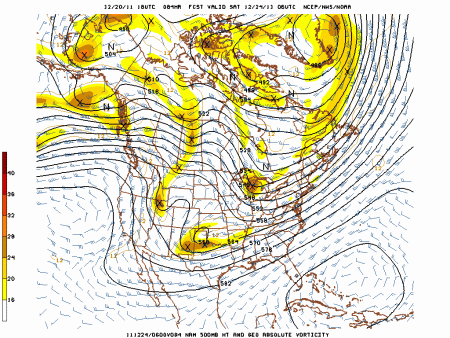
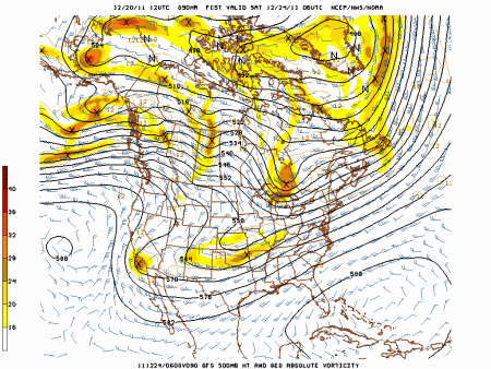
After this many of you boys and girls out there are wondering if the prospects for a white christmas have changed. If you only follow the GFS model then you would say no. However Other more reliable modeling says yes, by the way the US GFS is 4th among accuracy of meteorological models. Not very good.  I’m becoming more confident in a storm occurring however temperatures are questionable as to supporting snow. Bad news is the model which I think makes the most sense given the pattern has to be obtained through paid access  and I can’t show much of this model. However we can compare the NAM and GFS out at 84 hrs with regard to the upper levels. Remember the pattern has been for slowing moving systems than modeled in recent months. Also notice how the GFS really shears out the upper level energy, GFS bias is to have the pattern move to quick. The NAM image is a very close match to the ECMWF 500 mb image for Saturday morning.

NAM Saturday morning

GFS

The energy digging into the trough forms a storm christmas eve over the south which tracks northeast from Saturday night to Monday. Precipitation type will be trickier to pan down. dynamical cooling could lead to a mainly snow event as some colder air works in. However temperatures on the 12z ECMWF are in the upper 30′s for most of the storm which would yield rain. Still plenty of time to iron out the details.  

Daily forecast average of all locations in the state east of I-65.

Wednesday: AM showers 80%, isolated strong storms, breezy winds 15-25 mph in the morning. temperatures falling from 55-60 to 45-50 in the afternoon.

Thursday: still cloudy periods of rain 80% lows in the low 40′s highs 45-50.

Friday:  mostly cloudy lows in the lower 40′s highs in the upper 40′s.

Saturday: mostly cloudy lows in the lower 30′s highs in the mid 40′s

Sunday: rain and/or snow likely 60% lows in the mid 30′s highs in the upper 30′s, don’t count out a white Christmas.

Again the temperature and precip chances mainly follow the ECMWF and CMC  models past Friday.

I’ll update as needed on any storms overnight or Wednesday am.

MWG

Posted in Uncategorized | 2 Comments

Short term: more of the same pattern and a look @ white Christmas chances

1.  Sunday We will see a trough moving to the east as heights rise and ridging builds in. Once again a sign of more southerly flow, high pressure and a return to warmer than normal temperatures in the next few days. Sunday will also feature a week disturbance passing to our north which may increase high and mid level clouds. My thinking is for no precipitation from this.  Model guidance is in good agreement for lows Sunday morning around 26 north to 29 south. A few spots may get slightly colder. I suspect MEX guidance may be slightly to cool for highs in a few spots and I’m going more in line with NAM/00z ECMWF temperatures with highs around 50 in the BG region to around 44 in northeast KY.

2. By Monday the high pressure moves east and we’re firmly in southerly flow. I’m going with similar reasoning for highs Monday WAA should allow temperatures to reach the low 50’s across most of the region. A closed low will begin to approach the region. The GFS and ECMWF both bring in precip by late Monday. I tend to agree with this over the NAM which has a typical slow bias when it comes to timing precip. By Tuesday morning the EC is most aggressive with around .25 qpf across far northern KY with little rain south of I-64 for BG. I like the model agreement south of I-64 of dry conditions lasting into Tuesday morning. Going more in line with GFS qpf with light rainfall of around .1 across the CVG region.

500 mb nam image of closed low

../GemPakTier/MagGemPakImages/nam/20111217/12/nam_namer_060_500_vort_ht.gif

The closed low is over Texas with rising heights and WAA in our region. this closed low will move northeast into the Ohio valley Tuesday and Wednesday.

With this low moving northeast skies will be overcast with strong moisture advection into the region as well. This will lead to widespread showers from Tuesday afternoon into Wednesday morning. Total rainfall from .5-.75 could occur across the region. Light winds from Sunday through early Tuesday may increase to 10-15 mph for late Tuesday into Wednesday. Highs Tuesday should be in the 53-58 range with lows in the 40’s. With the southerly flow temperatures Tuesday night should be steady in the low 50’s with highs in the upper 50s’ in eastern KY with falling temperatures across Central KY.

– For Thursday I’m going to split the difference between the warmer EC and the cooler GFS with highs in the upper 40’s Thursday with high pressure building back in. This results in clearing skies. The GFS model brings a front through Friday with the region in a NW flow pattern while the Euro is much slower with the front leading to a few warmer than normal days. a GFS forecast would allow the next impulse to slide off the southeast coast with dry and seasonable weather while the EC would imply mild weather with another system cutting into the lakes. The CMC in more in line with the GFS and the EC  ensembles are a little faster than the operational, the brand new 12Z run is faster as well. Either solution means a white christmas is not likely but it’s still several days away. For now will lean more toward the GFS. A system should from late week in the southern plains and move northeast meeting up with the front along the northern branch.

Here is my line of thinking on the long range a full post is below My winter outlook is on www.mitchg.wordpress.com for refrence.

I see no signs of a white christmas. The friday system appears to move out to quick before a brief cooldown of a few chilly days of normal to slightly below temps around then. The next warm-up is already in sight around the 27th. each warm period is twice as a long as warmer compared to normal than the cool-downs folks.  LEX is 3*F above normal for the month. Jan may be better if the stratospheric warming works out. However like in most all la-nina winters Feb should feature a blowtorch of warmth. This winter will be warmer than normal and I’m finding it harder to figure out how we get 75% of normal snow this winter.

Forecaster: MWG

Posted in Uncategorized | Comments Off on Short term: more of the same pattern and a look @ white Christmas chances

Long term: Pattern change due to stratospheric warming may be coming in Jan

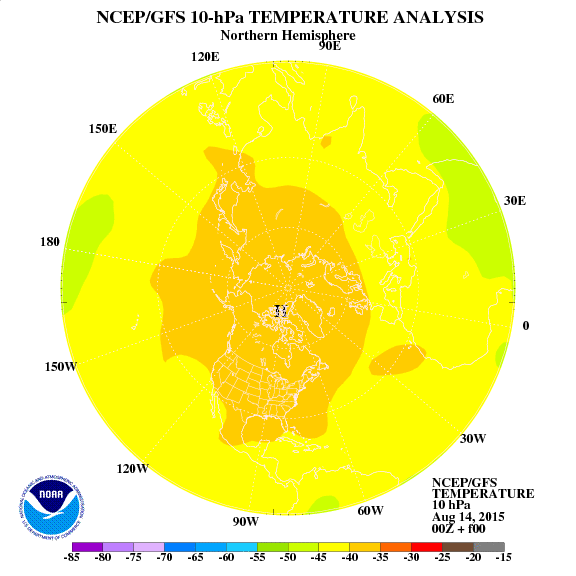
Over the past few months since the 1st of November we have been in a very unfavorable pattern for sustained wintry weather. Concerns over the – PNA in my winter outlook lead to a revised outlook for cold in the Rockies/west with warmth in the southeast and above normal precip over our region which has verified so far. For now I would cut back on snow over the great lakes some as the lake effect hasn’t been found yet. I’ve eliminated some of the analogs which had a cold December, others however may still prove OK given a stratospheric warming event affecting the January weather pattern. So far the climate models which had a blowtorch winter such as the ECMWF and CFS are spot on. However I expect this to change due to rapid warming in the stratosphere over the pole regions. The QBO which measures winds over the poles is tanking toward values which favor stratospheric warming episodes. The GFS model of stratospheric warming is showing a fair deal of warming in stratosphere over the next 10 days.

current above, day 10 below

Stratospheric warming typically lead to a much colder pattern across the United States about 2-3 weeks in the future with a switch in the AO to negative. Recall the past two winters featured a Negative AO throughout. A feature analog in my winter forecast was 2008-09 which had a stratospheric warming event in January, December was very mild and then February was warm overall. I expect much the same this winter.

Here are a look at some past January’s with regards to  surface temperatures in  which those months  had stratospheric warming events

And a close look at 08-09

Displace the cold further southwest and decrease in magnitude given a stronger cold PDO ( ridge off the west coast) for Dec.

Again this is only one factor that could influence our weather come January say around the 2nd week. Untill then I don’t see much change in the weather pattern with warm rain systems followed by quick shots of seasonable air then more warm-ups and rain. refer above to the short term for more.

Forecaster: MWG

Posted in Uncategorized | Comments Off on Long term: Pattern change due to stratospheric warming may be coming in Jan