
The GFS and ECMWF have very different interpretations of Easter weekend weather. While the GFS shows a couple of minor shortwaves rotating around the trough, the ECMWF has a blizzard for New England. How can two models that use the same physics equations and initialize with same data come up with such wildly different results?
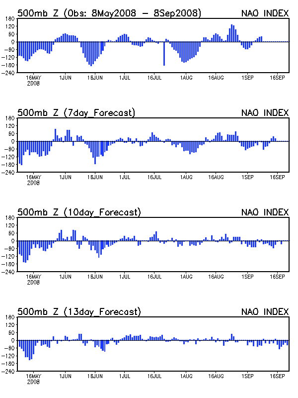
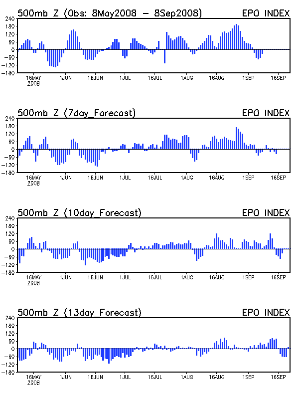
The models (12z runs) are very similar with events through 96 hours. Both the GFS and the ECMWF(scroll to 96 hr) have an initial shortwave over the Ohio Valley that should produce a nice swath of snow from southern MN to New Jersey Friday into Saturday. Both models also show a negative NAO with a blocking ridge over Greenland and a southward displaced lobe of the polar vortex over the Canadian Maritimes. This negative NAO (which has been very rare this winter) also shows up in the teleconnection indices.
Often, a Greenland block during a negative NAO can lead to the development of powerful East Coast storms. However, in this case, I believe the unusual position of the displaced polar vortex will eliminate the development of any deep lows until the storm is well off the coast. My primary support for this is the fact that the EPO is in the weakly positive phase, which shows up on the 96 hr GFS as the large polar vortex in the Gulf of Alaska. This creates a large cyclonic flow aloft that turns what is normally a very meridional pattern into a very zonal one. The reason the GFS is not deepening any of the shortwaves along the East Coast is because of the fast jet streak that develops southeast of the polar vortex over the NW Atlantic. By Sunday morning, another shortwave will rotate through the base of the trough while on Monday, an even stronger shortwave will dive into the Mid-Atlantic region. So why doesn’t the GFS, which is notorious for overdoing it with East Coast storms, keep the shortwaves weak?
Take a look at the position of the Monday shortwave relative to the position of the jet streak. The shortwave, as were all the others before it on Saturday and Sunday, are all moving through the convergent left rear quadrant of the jet streak. This means the upward motion forced by the positive vorticity of the shortwave at 500 mb is more than offset by the downward motion forced by the convergence of the jet streak. Hence, there is no surface deepening of the low. In fact, there is no surface reflection of the 500 mb shortwave at all. Essentially, positive EPO/negative NAO has created a zonal polar vortex over southeastern Canada that is a giant convergence zone, one that will crush any shortwave that dares enter the northeastern United States.
So what does the ECMWF see that the GFS doesn’t in hours 144 and 168? Since the PSU ewall site that I get my ECMWF model data from does not show the 300 mb level (if anyone has a different ECMWF site let me know), I can only speculate. However, the 18z run of the GFS sheds some light on what the ECMWF may be seeing. Compare the 12z GFS for Tuesday morning compared to the 18z GFS for the same time. While the 12z run has a 1004 mb low well out to sea, the 18z run has a 996 mb low that is closer to the coast. Why the difference? Look at the position of the shortwave relative to the jet streaks. The 18z has a staggered dual jet streak pattern with a shortwave located directly between the left front quadrant of the southern jet streak and the right rear quadrant of the northern jet streak. In other words, the shortwave (rising motion) is located directly beneath two regions of rising motion. You couldn’t ask for a more favorable location for surface deepening. The ECMWF may be seeing a similar type of phased jet streak further west over the East Coast, which is why it is developing the surface low so much.
I still like the GFS solution here since it just doesn’t make sense to me why a nor’easter would cut straight into the polar vortex. If any surface deepening does occur, I think it will be from a flatter wave that goes out to sea. This just doesn’t look like the proper setup for an East Coast snowstorm.