Forecast Friday

Short Term:

Happy Friday everyone! Today is going to be a warm one with highs around 83 and sunny skies! There will be a slight breeze out of the Northeast so it might be a good idea to chill in the shade and read a book! Friday night we can expect clear and cool weather, with a low of 55. The fair weather continues through Saturday with mostly sunny skies and highs around 85. Saturday night will have partly cloudy skies and lows around 57. Sunday we can expect a chance of isolated thunderstorms or otherwise partly cloudy skies and a high around 87.

Long Term:

Throughout next week we can overall temperatures in the 80s with most days with sunny skies, but the chance of rain may return later next week. We still have yet to pass the 90 degrees mark, what are your thoughts on that?

Bret G

Posted in Kentucky Weather | Comments Off on Forecast Friday

Wacky Weather Wednesday

Welcome back to wacky weather Wednesday! Today we will be talking about the fire whirl. What is a fire whirl? A fire whirl, also commonly known as a fire devil, is a whirlwind induced by a fire and is often composed of flames, ash, smoke, and any other smaller material. Fire whirls occur when intense rising heat and turbulent wind conditions combine to form whirling eddies of air. These eddies can contract a tornado-like vortex that sucks in debris and combustible gases. Fire whirls are technically not tornadoes since their vorticity derives from the temperature-induced lifting and surface winds instead of the tornadic mesocyclone aloft. Most of the largest fire whirls are spawned from wildfires. They form when a warm updraft and convergence from the wildfire are present. They are usually 10–50 m tall, a few meters wide, and last only a few minutes. Some, however, can contain wind speeds over 120 mph and persist for more than 20 minutes. Did you know that fire whirls have a bunch of different names? Such as a fire tornado, firenado, fire swirl, or fire twister. See you all back here on Friday!

To read more:
https://www.knau.org/knau-and-arizona-news/2021-11-17/earth-notes-fire-whirls-and-tornadoes

Posted in Kentucky Weather | Comments Off on Wacky Weather Wednesday

Forecast Friday:

Short Term: Expect a chance of lingering showers that will taper off before midnight with partly cloudy skies overnight. The low will be around 57 degrees so a nice night to open windows with a slight breeze from the Northwest. On Saturday expect a high of approximately 78 degrees and partly cloudy skies and Saturday to have a low of around 56 degrees.

Long Term: Expect warm temperatures Sunday into early next week! Memorial Day is looking to be a hot and sunny day so that is a great day to go to a local lake, like Nolin Lake. We may even hit 90s degrees next week!

Enjoy Your Memorial Day!

Posted in Kentucky Weather | Comments Off on Forecast Friday:

Wacky Weather Wednesday

Welcome to wacky weather Wednesday! This is the weekly blog where we will take a look at strange and rare weather phenomena that can occur throughout the world. This week let’s start it off with Fallstreak Holes.

A fallstreak hole is a large circular or round gap that can appear in altocumulus or cirrocumulus clouds. They are also known as “hole punch clouds”.They form when high to mid-level clouds are often composed of tiny water droplets that are much colder than freezing, but have yet to freeze. These “supercooled” water droplets try to freeze, and all they need is a little push. Planes passing through the cloud layer can bring that little push. The water droplet quickly freezes, grows, and starts to fall. A hole is left behind, which will start to expand outward as neighboring droplets start to freeze. They usually are a pretty sight to see and are completely harmless. Enjoy your Wednesday!

Danny McNeal

Source: https://cloudappreciationsociety.org/fallstreak-holes-%E2%80%93-a-new-understanding/

Posted in Kentucky Weather | Comments Off on Wacky Weather Wednesday

Forecast Friday

Happy Friday everyone! I hope you made it through that craziness of those afternoon severe thunderstorms. Going into Friday we can expect a very warm day of highs around 91 degrees and perfectly clear skies! So make sure to layer up on that sunscreen! Saturday will also have highs around 90 degrees and partly cloudy skies, both nights are supposed to have lows around 70. Late Saturday night into Sunday morning we will be having another round of storms moving through. There is a marginal threat of severe weather at the moment so keep an eye on it. As we look ahead to the workweek, Monday will be 73 degrees with partly cloudy skies. Enjoy the weekend!

Bret G

Posted in Kentucky Weather | Comments Off on Forecast Friday

Hello Summer Vacation!

Hello everyone! Here is a minor update for the summer. I will be running this show solo so wish me luck as I try to provide the best and sometimes comedic blog posts. I will be posting twice a week with “Wacky Weather Wednesday” about some crazy weather events from history and exciting weather facts. Also, I will be doing “Forecast Friday” with a post about the upcoming weekend and early next week. We will start this Friday, so see you then!

Posted in Kentucky Weather | Comments Off on Hello Summer Vacation!

Mother’s Day Weekend!

Happy Friday everyone! Today was a wet one with off-and-on rain showers throughout the day! Looking ahead to Saturday we can expect a cloudy day with a high of 65 and winds gusting up to 25mph. Mother’s Day will be a lot better with a high around 70 degrees and sunny skies! Next week we can expect warmer temperatures to return especially early on in the week.

Today is also National Space Day so I talk briefly about the GOES-18 satellite. GOES-18 is the third of the “GOES-R Series”. It is the current generation of weather satellites operated by the National Oceanic and Atmospheric Administration to take enhanced photos and scans of the Earth’s surface. “GOES” stands for Geostationary Operational Environmental Satellite.

Happy A Great Weekend!

Bret G

Posted in Kentucky Weather | Comments Off on Mother’s Day Weekend!

Commencement Outlook

Good morning, everyone! We hope your finals are going well!

If you are in or attending the graduation events hosted by the university, you may want to have an umbrella handy. For, an incoming low pressure system is to bring precipitation chances to our region of the country. Whilst the risk for severe weather is low, it is still important to acknowledge the chance. Theta-e, to which is a good indicator for instability with storms, has the potential to nose into the southern counties of the state. This may result in stronger storms, capable of producing high winds, heavy rainfall, and lightning. As of now, showers and storms will remain scattered throughout the late afternoon and remainder of the day. Remember to stay weather aware!

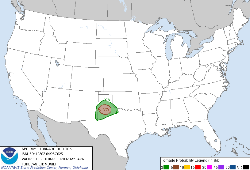
Tornado outlook for today (Storm Prediction Center)

Farewell, Meteorology Blog…

For a while now, I have been a contributor for the Meteorology Blog, but all good things must come to an end. This will be my final post for the university, as I graduate today, and will pass the torch onto undergraduates that can benefit from working for this team in the way that I did.

It has been an absolute honor to serve this community. I would like to thank you, personally, for supporting us!

Sincerely,
Liv

Posted in Kentucky Weather | Comments Off on Commencement Outlook

Severe Weather Risk

Good Afternoon

The past couple days have been quite nice and sunny throughout the past couple days, this is all about to change. as we move into tomorrow, a warm front will pass through the area which will help create a chance for storms ahead of the cold front. a few supercells may form ahead of the cold front which will bring the threat for damaging winds, hail and a couple tornadoes are possible. the best timing for these storms will be from mid afternoon to early evening (3pm-8pm). A second round of storms is possible from 6pm to 11pm that will form ahead of the main cold front these storms will cause damaging winds. Make sure you have ways to receive alerts incase warnings are issued.

Stay Safe out there!

Posted in Kentucky Weather | Comments Off on Severe Weather Risk

Today in Weather History

Good afternoon to you! How are you holding up for finals? We hope well!

On this day, in 1868, the state of Illinois fell victim to severe thunderstorms that produced catastrophic tornadoes. One in particular had a path of fifteen miles, tearing through the counties of Warren and Knox. In the vicinity, a town known as Ionia was completely demolished, along with sixteen homes and two churches across the state. Unfortunately, this storm took the lives of six people and injured forty others. You may be thinking: fifteen miles has to be the longest track on record, right? But, you would be sadly mistaken. Not even the Mayfield, Kentucky tornado broke the country’s record. The longest tornado path ever recorded was known as the “Tri-State Tornado,” to which took place in 1925, and was on the ground for two hundred and twenty miles! Isn’t that insane?

We hope you learned something new today! Good luck on finals!

Posted in Kentucky Weather | Comments Off on Today in Weather History