Summer Drought coming???

First a news headline:

A mix of heavy snows melting and several hvy rain producing nor-Easters has led to a epic flood in New England this is worst flood since 1939 for Rhode Island.

http://www.windstream.net/wind/portal/NewsChannel.aspx?ArticleID=D9EP9Q680&CatID=TopHeadlines

While for us here in Kentucky we have had several months in a row of below normal precipitation and a deficit has developed. This coupled with an expected transition to la-nina by late summer lead to the likelihood of a drought forming this summer across Kentucky. This transition from el-nino to la-nina can be compared to the summers of 1999 and 2007 when moderate to strong el-ninos in the wintertime shifted to la-ninas by late summer. A drought would also mean a hot summer overall. This conclusion does not match up with the climate prediction center which has an equal chances forecast this summer, which is it may be colder or warmer than normal.

Bowling Green -5.78 inches

Lexington -5.01 inches

 Louisville -4.73 inches

Jackson -1.55 inches

London -2.51 inches

US Drought Monitor, March 23, 2010

Posted in Kentucky Weather | Comments Off on Summer Drought coming???

Spring fever is coming!!!

1. Before we get to spring fever a dreary Monday is in store as low pressure will be slow to depart the eastern seaboard. As a result clouds and drizzle will likely linger into the first of Monday with highs only in the low 50’s with some nw winds as well. Both the nam and gfs linger the clouds and drizzle for most of the day.

2. Tuesday should see the low move a little further east allowing for a mix of sun and clouds with highs in the upper 50’s to lower 60’s.

3. By Wednesday a high pressure moves across the gulf coast and southerly flow starts to come north into the region as ridging develops over the eastern and southern half of the country. With considerable sunshine Wednesday  highs should get well into the 70’s!!  This will be the start of a major pattern change which will be warmer and more active in terms of thunderstorms. For Easter weekend the first 80’s temps of the season are looking likely. Here is a look at how the 00z euro develops the ridging later on in the week.

4. The next update this week will discuss the potential for a drought this summer. The third post will be a forecast for Easter weekend.

Posted in Kentucky Weather | 1 Comment

Another nice day before more rain!

Its still pretty chilly out this morning with a current temperature of 34 at 8 o’clock. Don’t worry though, it should warm up nicely this afternoon. If you don’t have plans to be outdoors today you need to make some, because we are going  to have beautiful blue sunny skies today. Today we can expect temperatures to climb into the upper 60’s for our high. Tonight the low should be around 50 degrees. Rain is on the horizon though, but shouldn’t effect our weather today.

rain

The rain should start overnight into early Sunday morning last throughout the day and linger  on into the early morning hours of your Monday. Sunday’s high should be around 60 degrees with a low around 40. However if you can hold tight through Sunday and Monday you will be rewarded next week. Next week its looking like we could see our next big warm up. As of now it’s looking like temperatures could reach the lower to mid 70’s by mid week. Thanks for checking your weekend forecast and I hope everyone enjoys there weekend!

Posted in Kentucky Weather | Comments Off on Another nice day before more rain!

Rain on the way!

If you have the chance to get outside today you better do it because rain is headed our way on Thursday.  Today is going  to be absolutely beautiful with high temperatures near 70 degrees and a low tonight of around 50. Winds will be out of the south today around 5 to 8 mph. However as I mentioned, that won’t last long. The rain is expected to reach our area sometime after lunch tomorrow. Both the 12 UTC run of the GFS and the NAM are in agreement with the arrival times and show the rain arriving around  1  o’clock. Both models are also showing the rain to stick around all the way through Friday morning before finally exiting the area. There is a slight chance for a severe threat, but that should remain to our south. However there is still the possibility of having a few storms around on Thursday afternoon  but once again nothing severe.   Over the course of this rain event we can expect around one inch of rainfall to occur. Thursday high temperatures will be cooler due to the clouds and precip. We can expect highs to reach the low 60’s for Thursday. Friday looks to be even cooler as the cold front passes through our area. Friday looks to be around the mid 50’s with clouds remaining in the area. As of now Saturday is looking to be nice, but I will have more on the weekend forecast coming up on Friday. Thanks for checking WKU’s met blog!

Posted in Kentucky Weather | Comments Off on Rain on the way!

Cold Monday!

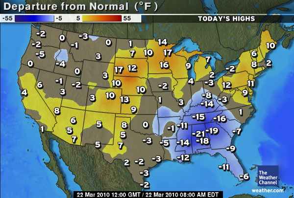
The same storm that dumped snow over the southern plains this weekend is now effecting our area.  The low pressure system is currently located over western Tennessee and  is bringing us a cold and gloomy Monday. The low pressure center is associated with a trough that is swinging through the southern US. The trough has brought in another shot of cold air that is bringing in well below normal High temperatures across the entire southern US.normal departure from high

The above map is showing the departure from normal expected high temperatures for this time of year. Today in Bowling Green we can expect a high of 44 and a slight chance of showers later this evening into the overnight hours as this system continues to push through the area. Overnight the low temperatures should only dip down into the upper 30’s due to the cloud cover that will remain with us.  Continue reading

Posted in Kentucky Weather | Comments Off on Cold Monday!

System slowly approaching…

Trough continues to dig across the central US, which will eventually lead to a closed low pressure system. The upper-level low will push into Mississippi by tomorrow, with the surface low located to the north of this. Continue reading
Posted in Kentucky Weather | Comments Off on System slowly approaching…

Clear is here! But not for long…

That’s right, friends. Clear skies are here and should accompany us through the rest of the week, before the next system moves in this weekend. Low pressure system that has been stalled off of the east coast has finally tracked to the NE. This has allowed breaks in the clouds to transform into mostly sunny skies. Continue reading
Posted in Kentucky Weather | Comments Off on Clear is here! But not for long…

Spring is NICE!

Yeah, maybe we have had a few consecutive days of the gloom and rain, but a change is on the horizon! Keeping clouds around for most of the day, with the trough still in place overnight. All in all, not much to discuss this forecast period. With the stacked low that brought us the unfavorable conditions to our E now, high pressure is pushing across the plains, making its way to us. Continue reading

Posted in Kentucky Weather | Comments Off on Spring is NICE!

Heavy Rain Today

The Mid-South will get a heavy dose of rain today from the low pressure system currently out over the upper-Mississippi valley. Continue reading

Posted in Kentucky Weather | Comments Off on Heavy Rain Today

Showers/Thunderstorms on the way

It appears that we may get our first decent round of thunderstorms of the year over the Mid-South on Thursday. Continue reading

Posted in Kentucky Weather | Comments Off on Showers/Thunderstorms on the way