
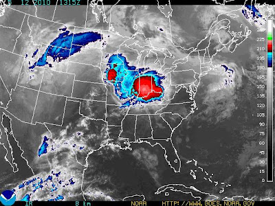
The pattern doesn’t seem to be changing much, with several pieces of energy traveling through the longwave trof, keeping slight chances of precipitation for the area through much of remaining work week. Should keep mostly cloudy skies across the region, with a more sunny approach expected tomorrow. For now, the precipitation shield remains to our north, as originally thought. A very large MCC(Mesoscale Convective Complex) is to our north, dumping ample amounts of rain across IL and IN. You can see this system from the IR image below…
Temperature wise, expect things to remain warm with highs in the upper 80’s today and tomorrow, with lows in the upper 60’s. To kick off the weekend Friday, we should only reach a high in the mid 70’s, along with our best chance at some precipitation in the foreseeable future. I’ll have another update when we get closer to time. Enjoy the rest of your week!