
Today: High- 98° Low- 67°
Today was and still is a very hot day here in Bowling Green, KY.
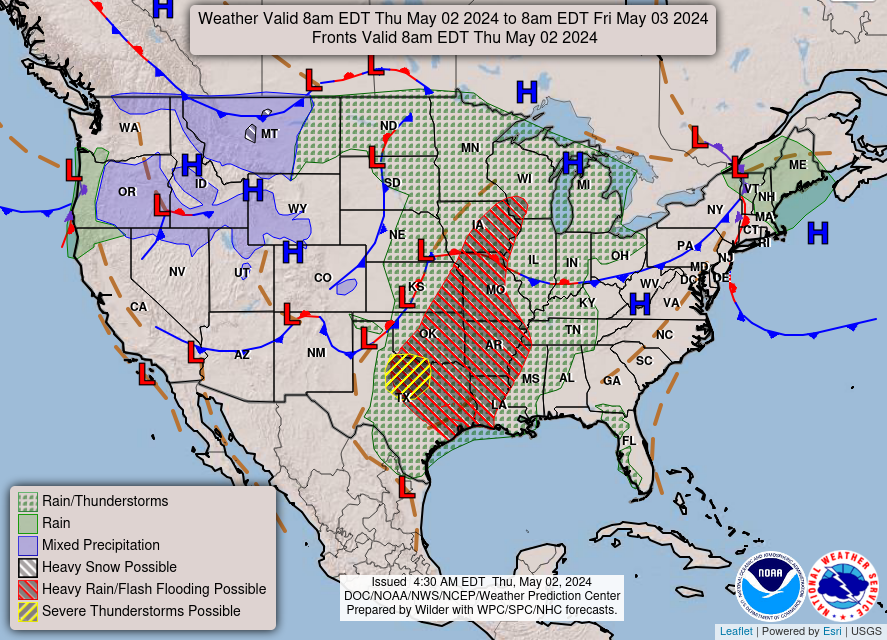 |
| NWS National Forecast |
The dominating high pressure forced for mostly sunny skies in the region. Fortunately, the system is moving on to make room for a cold front that could possibly bring us some rain!
Wednesday: High- 86° Low-66°
Tomorrow is showing promise for a cool down as the cold front moves in and brings with it a chance of rain.
 |
| NWS National Forecast |
According to the NAM, we should start to see spotty showers around 6am Wednesday morning. The main line of rain should move in soon after. We will have to keep an eye out for precipitation amounts as the ground could be unable to absorb the full amount of rain at that time.
 |
| NAM Simulated Radar Reflectivity |
The greatest chance for rain will begin in the late afternoon/ early evening, so make sure to take your umbrella with you for the commute home.
Weekly Outlook:
Tonight: Increasing clouds, with a low around 69. South wind around 6 mph becoming calm in the evening.
Wednesday: Showers and thunderstorms likely, mainly after 4pm. Cloudy, with a high near 86. Calm wind becoming southwest 5 to 7 mph in the morning. Chance of precipitation is 60%. New rainfall amounts between a quarter and half of an inch possible.
Wednesday Night: Showers and thunderstorms likely. Cloudy, with a low around 68. West wind around 6 mph becoming calm in the evening. Chance of precipitation is 70%. New rainfall amounts between a quarter and half of an inch possible.
Thursday: Showers and thunderstorms likely, mainly before 2pm. Mostly cloudy, with a high near 83. Light west wind. Chance of precipitation is 60%. New rainfall amounts between a tenth and quarter of an inch, except higher amounts possible in thunderstorms.
Thursday Night: A 30 percent chance of showers and thunderstorms, mainly before 8pm. Partly cloudy, with a low around 64. Northwest wind around 5 mph becoming calm in the evening.
Friday: A 20 percent chance of showers and thunderstorms. Mostly sunny, with a high near 84.
Friday Night: A 30 percent chance of showers and thunderstorms, mainly after 8pm. Mostly cloudy, with a low around 60.
Saturday: A 30 percent chance of showers and thunderstorms, mainly before 8am. Partly sunny, with a high near 73.
Saturday Night: A 20 percent chance of showers and thunderstorms before 8pm. Partly cloudy, with a low around 53.
Sunday: Sunny, with a high near 71.
Sunday Night: Mostly clear, with a low around 51.
Monday: Sunny, with a high near 77.
Monday Night: Mostly clear, with a low around 55.
Tuesday: Sunny, with a high near 83.