More Severe Weather Chances This Weekend

According to the Storm Prediction Center, the Bowling Green area has a chance of seeing severe weather each of the next 3 days. Here’s the convective outlook for tomorrow:

04_07_11_day2otlk_1730

The severe threat tomorrow looks to be marginal. Some degree of instability is forecast to be in place along with moderate wind shear, but upper level ridging will tend to suppress widespread convection. Also, the energy that could provide lift for storms is expected to move through during the late morning to early afternoon hours, which isn’t optimal timing for severe storm formation. However, if storms can fire, they will be capable of producing some hail and strong winds.

More on this weekend’s severe threats

Posted in Kentucky Weather | Comments Off on More Severe Weather Chances This Weekend

Severe Weather Recap

As expected, a large severe weather outbreak took place over the southeastern U.S. yesterday. However, it turned out to be even bigger than expected, with over 1,200 instances of severe weather reported between 7 AM CDT Monday and noon today. Most of these reports were of damaging winds associated with a huge squall line that swept across the Southeast, although 23 tornadoes were also reported. This preliminary tornado count will probably increase over the next few days as storm damage surveys throughout the affected areas differentiate between straight-line wind damage and damage caused by tornadoes.

110404_rpts1

The above map shows that damaging wind reports were widespread in Kentucky, and a few tornadoes were also reported in the state. Most notably, a tornado did significant damage to a manufacturing plant near Hopkinsville, resulting in several minor injuries. Damage surveys conducted today have also confirmed that an EF-1 tornado occurred in southern Butler County and two separate tornadoes in Ballard County, one EF-2 and one EF-1. The Bowling Green area was spared the worst of the storms. Winds gusted to around 40 mph and heavy rain fell when the squall line passed through the area, but no major damage was reported in or near the city.

For Bowling Green, today’s cooler weather will be followed by a quick warmup into the low 70s tomorrow and warm conditions throughout the rest of the week. Rain chances return to the forecast on Friday, and there is a possibility for another severe weather outbreak late this weekend. This event is still a long way out though, and the potential for severe storms will be better known later this week.

Posted in Kentucky Weather | Comments Off on Severe Weather Recap

Severe Storms Possible Tomorrow

Summary:
-Severe weather possible in the early afternoon hours tomorrow
-Damaging winds currently expected to be the main threat
-Cooler temperatures tomorrow night and Tuesday

A strong upper-level trough will eject out of the Rockies tomorrow, leading to the development and intensification of a surface low pressure center in the the Upper Midwest. This will drag a strong cold front through the Bowling Green area during the early afternoon hours tomorrow. Ahead of the front, strong southerly winds will advect warm and moist air into the area, creating at least a modest amount of instability and energy for severe storms to form.

2011_04_03_day2otlk_1730

The map above shows where the Storm Prediction Center has outlined a slight risk of severe storms for tomorrow. According to the SPC, there will be a 30% chance of severe weather within 30 miles of a point in the Bowling Green area. Currently, the magnitude of this event is expected to be limited somewhat by a lack of instability and wind profiles that are expected to result in linear rather than discrete convective modes, which favor a damaging straight-line wind threat over a tornado threat. The instability is expected to be held in check by a weakening line of storms that is expected to move in during the morning hours, bringing clouds to the area and limiting heating of the boundary layer. However, if more instability develops than the models forecast and/or wind profiles turn out to be more favorable than expected, a more substantial wind and tornado threat could develop.

04_04_1800_sounding
04_04_1800_hodograph

The images above show a model forecast sounding and hodograph from the SREF (Short Range Ensemble Forecast) for 1 PM tomorrow in Bowling Green, just before when the cold front is expected to move through. They show that very strong speed shear will be present, with winds increasing from around 10 knots at the surface to almost 60 knots at the 850 mb level. The winds will veer from southerly at the surface to southwesterly from 850 mb upward, providing good directional shear in the low levels. This favorable shear should compensate at least somewhat for the anticipated lack of instability.

Posted in Kentucky Weather | Comments Off on Severe Storms Possible Tomorrow

Blah weather continues…..

Highlights
-Upper level trough keeping temps down on Thursday.
-Disturbance will bring slight chance of rain on Thursday night and Friday.
-Ridging and southwesterly flow returning by Sunday.

Forecast
Some clearing will take place behind yesterday’s precip on Thursday, however it looks to be mostly cloudy under northwest flow, with a trough dug out of the eastern US. General cloudyness and northwest winds on Thursday will keep high’s in the upper 40’s. Thursday night there is a slight chance for light rain as a disturbance moves through the flow allowing for some precipitation. Low temps will be in the mid-30’s. Friday continues a chance for rain, however the trough should begin to lift and temps will increase as the airmass begins to modify. Highs will be in the mid 50′ s on Friday with lows in the low 40’s. The same can be said for Saturday with the exception of clearing and partly sunny skies. Further out, temps begin to moderate Sunday into Monday as a warm front passes through our area Sunday night, bringing temperatures into the 70’s on Monday. This will be short lived however,A as a low pressure system is predicted to impact the area with thunderstorms on Monday.

Posted in Kentucky Weather | Comments Off on Blah weather continues…..

Winter Just wont go away!

HIghlights
– Continued Cool Temperatures
– Rain Chances Tues into Wed
– Warm up expected next weekend

Forecast Discussion
Currently the upper level impusle that affected our weather last night is moving out of our area. Sky’s should begin clearing today as this impusle quickly moves east. Today looks drier, however still cool, with highs near the 50 degree mark. Tonight will also be dry as Bowling Green is on the edge of ridge of receding surface high pressure. It will again be a chilly night with low termperatrues of around 33. The next system that will affect our sensible weather should be in the form of a low pressure system that will be forming in western Texas. A trough of low pressure should begin to enter our area on Tues. increasing rain chances, with the more constant precipitation occuring on Tuesday night. This rain shouldnt be terribly heavy, however cooler temperatures on Tues night may support a mix of rain and snow well north of our area. This will not affect Bowling Green, and even areas well north of here would have a minimum impact as ground temps are too warm in late March. Temps on Tues should reach in the Mid 50s with rain chances increasing throughout the day.Tues night will be all rain for us with a low around 38. Rain chances dwindle on Wed, but temperatures will remain cool, with a high around 47 under cloudy skies. The weather will remain cool, with a warm up expected late this weekend.
HPC forecast for Wed. morning

Posted in Kentucky Weather | Comments Off on Winter Just wont go away!

Rain..Rain..

Highlights:
-Major rainmaker on tap for Thursday
-Cooler temperatures on Friday
-Active pattern setting up for next week

Forecast:
Warm front will move north past Bowling Green early Thursday Morning, bringing warmer temperatures and raising dew points. Moisture will be streaming northward in front of a center of low pressure that will deeping in Oklahoma. By noon this front will stall somewhere near the Ohio River and a sheild of precipitation will spread in coverage across Kentucky. By later in the evening, the low will ride up along this boundary and bring another round of heavy precip. Most of Kenucky is set to recieve widespread rainfall amounts of 2″+. The axis of heavier precipitation will reside along the Ohio river, where the greatest forcing exists along the stalled warm front. A potential exists in southern Kentucky for thunderstorms (with a small possiblility of severe) with heavy rain and strong winds being the main threat. Instability (energy) will be minimum at best, so as of now only thinking there will be a few rumbles of thunder and heavy rainfall. A cold front will andvance eastward, with this center of low pressure, and precipitation should come to an end Fri. morning. Temperatures on Fri will remain cool with highs only reaching the upper 40’s and lows Fri. night in the mid 30’s. Saturday looks to be dry and seasonalby warm with highs in the middle 50’s and lows in the 40’s. With a chance of rain returning on Sunday.
Quantitative Precipitation Forecast (QPF) from HPC

Posted in Kentucky Weather | Comments Off on Rain..Rain..

Cloudy Monday(2/21)….Showers?

Highlights:
-Warm air and southwesterly flow bringing in higher temperatures
-Chance of showers increasing through the day on Monday.
-Cooler temperatures on Tues.

Discussion:
After warm frontal passage on Sunday, southwesterly flow will continue into Monday bringing with it some Gulf of Mexico moisture and a good chance of showers. A low pressure system will move across Indiana Monday night, dragging behind it a cold front which will drop temperatures Monday night into the low 30s.This front should be a focusing mechanism for precipitation, so expect better coverage towards the evening on Monday. Some of the rain showers could be mixed with flurries as cold air filters in Tues. morning, but no impact is expected from this as ground temperatures are too warm. Tues. temperatures will be much cooler with partly cloudy skies, and high temperatures in the upper 40’s.Temperatures increase on Wed. as southerly flow returns in the form of a warm front. This ahead of a late week low pressure system that will affect our area on Thurs. High temperatures on Wed. should top out in the upper 50’s.

Forecast for this evening

Forecast for this evening

Posted in Kentucky Weather | Comments Off on Cloudy Monday(2/21)….Showers?

Cold and Snow Give Way to Major Warmup

Last week proved to be a very cold and snowy one in the Bowling Green area, with near-record lows and two separate accumulating snowfall events. First, on Monday, morning rain quickly changed to wet snow as a surface low passed just southeast of the area. This event produced 2.1 inches of snow in Bowling Green, with much higher totals in southwestern Kentucky where localized heavy bands of snow set up. 6 inches of snow fell at the National Weather Service office in Paducah, while Draffenville, KY hit the jackpot with 10 inches. On Wednesday, the Bowling Green area found itself on the northern periphery of a large area of snowfall over the south central U.S. This system dropped an additional 3.8 inches of snow in Bowling Green.

In the wake of this system, the deep snowpack combined with an arctic airmass characterized by calm winds and clear skies to drive low temperatures down well below zero in Bowling Green. The official low at the Bowling Green airport on Thursday morning was -3, while the Kentucky Mesonet station at the WKU farm just south of Bowling Green recorded a low of -7. Friday morning was even colder, with a low of -10 reported by the Mesonet station. A map of Friday morning lows from the Kentucky Mesonet shows that the coldest temperatures were over southern and southwestern Kentucky, where the most snow cover was in place. Lows were much “warmer” over eastern and northern Kentucky, where little snow fell from either system.
2-11-11_lows

In the wake of the snow and cold, ridging aloft and southerly surface winds brought about a dramatic warmup for much of the eastern U.S., with highs reaching the lower 60s in Bowling Green yesterday. A cold front brought a temporary cooldown into the lower 50s today, but temperatures should be on the increase through at least Thursday before better rain chances return to the forecast on Friday.

Posted in Kentucky Weather | Comments Off on Cold and Snow Give Way to Major Warmup

Snow Monday and thinking north for later in the week

Right now my thinking matches up well with the 12z ECMWF and JMA from Saturday for later in the week and the Sunday 00z GFS for Monday.

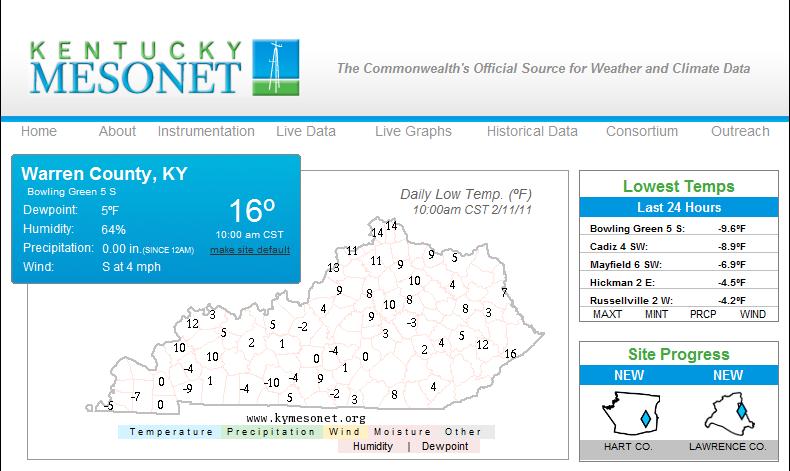
Today should be a mostly cloudy day with highs in the 40′s ahead of the next frontal system. This front moves east on Monday bringing in another surge of cold air and temperatures from 32-36 from A Lexington to Bowling Green line northwest and upper 30′s to mid 40′s further east. At the same time another wave of low pressure will track from the deep south up the west slopes of the apps. Snow will break out from a BWG to LEX line northwest around noontime Monday with rain for the rest fo the region during the day this rain will change to snow by evening and precipitation will end by Tuesday morning with lows in the mid 20′s.  I expect snow accumulation to mainly be on grassy surfaces Monday afternoon and evening but black ice may be an issue by Tuesday. the ECMWF is most robust with QPF  around 1/2 inch , the NAM only has from .1-.2 with the GFS in the middle. For now I’ll go with the GFS on qpf with the modeling in good agreement on the low track.  This suggests region that see mainly snow could get a few inches. Worth noting is thermal profiles are quite  a bit colder with both thickness and 850 temps which may also allow for some dynamical cooling to kick in.

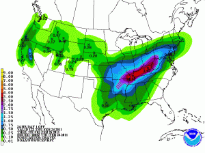
GFS qpf for this event

i’d figured on giving the GFS a little credit before ripping it and giving it a faling grade on the next storm.

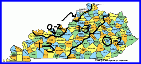
On all the models I’m notcing diffuclites in where the low will form. The GFS Wednesday morning forms it over el-paso TX

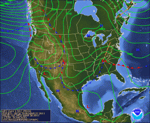
let’s take a look at the 500 mb pattern for the overall flow. this low should move east.

but wait suddenly the low is north of Tampico mexico well south of Brownsville. this presents a disjoint between the low and the region with the best isentropic lift ( advection of pressure and moisture resulting in precipitation development)

thus the gfs is extremely disorganized with everything. the new 00z CMC is having similar problems with the addition of convective feedback.  the UKMET also has this odd southern route.

still both of these models have snow  although not much.  The ECMWF and JMA 12z Saturday make the most sense a low that tracks east from el-paso to Georgia then off the east coast.

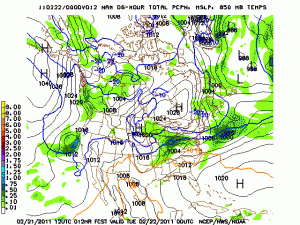
I’ll show the JMA due to copyright issues

I may have to give into the modeling and say we’re far south but I’m not buying it yet.

For now i stick with track 2

as you can tell I’m starting to worry a bit for the south and really getting worried for regions north of 1-64 that this will be a miss with TN and the deep south getting all the fun.

EITHER WAY THE LAST DAY OF WINTER IS FRIDAY AND THE FIRST DAY OF SPRING SATURDAY. it’s now or next winter.

MWG

Lee will keep the blog updated for the next week so check back to see how much snow we could get.

Posted in Kentucky Weather | Comments Off on Snow Monday and thinking north for later in the week

to far west for snow tonight

Sorry for the delay with getting an updated forecast out. I’ve known  since this morning this is going to far west for snow. In my last post i discussed the westward model trend well the upper low is slightly stronger meaning a slightly more westward track and the main 1-3 snow band now goes through west ky. we are seeing warmer air ahead of the low and light rain which should change to some light snow showers for Saturday.

I’ll update tomorrow on a system Monday which would normally generate hype but is the middle child in this series of storms. I’m watching for low pressure to develop fairly quickly over TN Monday and ride northeast developing a period of precipitation with cold air rushing in behind the question is mainly a snow event then we make up for tonight’s 1-3 if a mix then more coatings.

The big deal next week will be Wednesday and Thursday I’m expecting temperatures in the 20’s this coupled with a gulf storm as well throwing moisture north ahead of a strong low pressure system right now I’m leaning more in the direction of Saturday’s 00z CMC, Friday’s 12Z ECMWF and Friday’s 18Z DGEX all of which bring a heavy snowfall to the region. This snowfall has the potential to be quite excessive due to the fact of high snow ratios so only .5 qpf gives us 10 inches. However the GFS model is further south but this is standard operating procedure with this model as we have seen with this last system trends say it goes further north and west with time on the track. Even with a northwest shift on those other models we’re still good for snow mid-week.

I’ll start going over these systems more tomorrow and then hands things off to Lee who will have a busy week next week.

Posted in Kentucky Weather | Comments Off on to far west for snow tonight