Let the Model Wars Begin

Today low pressure is moving northeast into the northeast which is still providing for some cloud cover today with fair skies overall and a nw flow with highs in the lower 70’s. Tomorrow skies should be mostly sunny with the nw flow keeping highs in the low to mid 70’s. Heading out later this week we have model disagreement on the track of Nicole. One camp we have the Canadian/ nam which brings the track up the Appalachian mountains and phases the system with a deeping trough. The other option is for the tropical system to move up the east coast and not phase till it reaches canada. the first track would bring mostly cloudy condtions Thursday and Friday with the rain bands moving through a good portion of KY and highs in the 60’s. The second option would bring what most forecasts indicate sunny skies and 70’s.

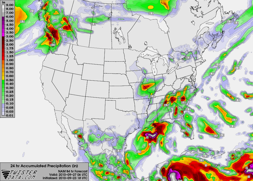
Thursday night 06z nam

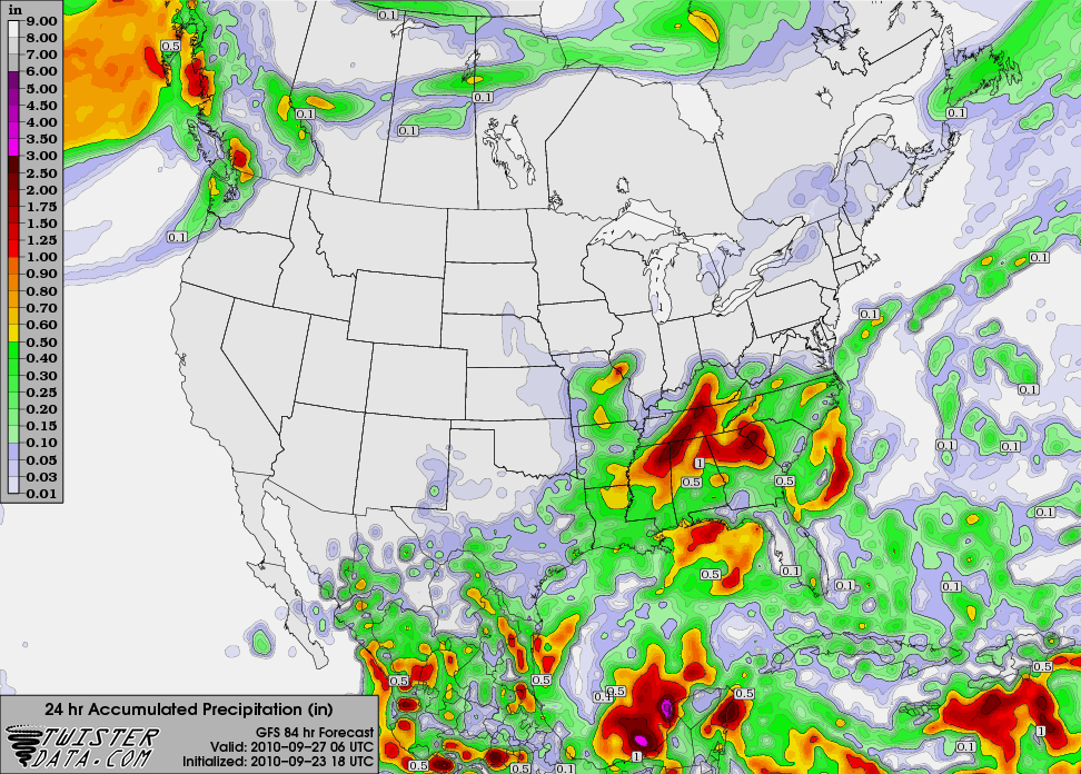
Thursday night 06z gfs

Posted in Kentucky Weather | 1 Comment

WKU Meteorology blog makes Top 50 list

The WKU Meteorology blog was included in a list of “50 Scholarly Blogs for Climate Science Students” put together by the website Onlinecollege.org. The WKU Meteorology Blog was among 22 “Climate, Weather, and Meteorology blogs” that made the list, which can be found at http://www.onlinecollege.org/2010/09/20/50-scholarly-blogs-for-climate-science-students/. Of the 22 climate and meteorology blogs, only four were run by American universities, and include blogs from Columbia University, Yale University, and the University of Wisconsin. Here is how the WKU Meteorology blog is described in the list…

Although Western Kentucky University’s Meteorology program focuses mainly on weather and climate in the Midwestern and Southern regions of the United States, there are still plenty of valuable universal lessons to be gleaned from their blog.

Posted in B.S. Meteorology degree | 1 Comment

major pattern change in progress

Overall we have low pressure moving up the east coast with a nice pipeline of tropical moisture. Low clouds and light showers will be present on the backside into Tuesday. Also NW flow will be in place for the week. This means highs will be more seasonable in the 70’s with lows in the 50’s.  If you’re wondering why we’re seeing this pattern change one may look to the PNA which has been running strongly negative for a while now has becoming strongly positive and the AO will be going negative as well. This sets up for a period of normal to below normal temperatures over the next 2-3 weeks.

Posted in Kentucky Weather | 1 Comment

Yesterday’s squall line dropped 0.11 inches of rain at the WKU Farm with a maximum wind gust of  27.5 miles per hour. While certainly not the most impressive total, this was the first time in nearly two weeks that a single event brought Bowling Green more than a tenth of an inch of rain. While this helped a little bit, Bowling Green is still substantially below the average rainfall for the month of September.
Typically, Bowling Green receives 4.13 inches of rain in an average September. This September, however, we have only received 1.41 inches. This lines up with the moderate La Nina that is currently occuring, which typically brings warmer and drier conditions to the southeastern U.S. That said, now that the blocking pattern has  broken down, what is the likelihood of some of this deficit being made-up?

While neither the GFS or the NAM explicitly calls for much precipitation over the course of the next few days, the National Weather Service in Louisville has included a 50% chance of rain for Monday, with accumulations between a tenth and a quarter of an inch. These chances hinge on the development of a high amplitude trough over the Eastern U.S. The forecast precipitation areas in the models have been trending west, making it more and more likely that we should see some rain.

Posted in Kentucky Weather | Comments Off on

Front moves through, brings in cooler temperatures.

At long last, the summer heat has broken! The dominant ridge that has been sitting in place over Kentucky for the past several days has been replaced by a trough, bringing in substantially cooler temperatures that will finally make it feel like summer has ended. While we cannot rule out the possibility of a fall heat wave, it would be rather unusual for that to occur.

The cold front associated with this transition brought our area a somewhat impressive squall line. While the SPC did not receive any reports of severe weather, a series of thunderstorms dropped plenty of rain across the state as Bowling Green temperatures dropped from the upper 80s to the mid 70s over the course of an hour. A more detailed analysis of this system will come tomorrow, as the Kentucky Mesonet releases precipitation totals for today across the state.

Posted in Kentucky Weather | Comments Off on Front moves through, brings in cooler temperatures.

Is Autumn finally arriving?

For the past several days, we Kentuckians have been stuck with the same aggravatingly hot conditions generated by this more or less stationary ridge over the southeast. Bowling Green started off fall with the mercury tying a record high temperature of 95°F today. Forunately, these hot conditions may only have another day left, as a long-anticipated cold front associated with a mid-latitude cyclone moving across the northern part of the country will bring cooler conditions to the area on Saturday, along with a chance of thunderstorms as the front moves through Friday afternoon.. Forecast highs over the next week should drop into the low 70s by Monday, with a slight rebound towards the upper 70s by the end of next week. This should also bring a fair amount of precipitation into the region, with the National Weather Service calling for a 40% chance of rain on Monday.

Of particular interest is the way that the GFS and the NAM are handling the increased odds of a precipitation event on Monday. The NAM, shown below on top, does not call for any rain immediately over Bowling Green, instead favoring precipitation falling more or less everywhere around it. On the contrary, the GFS, on the bottom, is calling for upwards of 2 inches in the Warren County area. While chances are that the GFS is overestimating the amount of precipitation associated with this airmass, it is indicative that our dry spell may finally be coming to an end.

nam_221_2010092318_f84_pcpin_24_hr

gfs_3_2010092318_f84_pcpin_24_hr

Posted in Kentucky Weather | Comments Off on Is Autumn finally arriving?

Red Flag Warning till 8pm

The National Weather Service has issued a Red Flag Warning for Warren County for more click here.

Posted in Kentucky Weather | Comments Off on Red Flag Warning till 8pm

Weekend Cooldown Still on Track

Hot conditions will continue for the next few days, and Bowling Green even has a shot at breaking its record high of 98 today. On Friday, the cold front should finally approach the area, bringing a limited shot at some rainfall. Highs could still be in the low 90s on Friday, depending on how much cloudiness and rainfall we get, but by Saturday the front will be through the area and a much more comfortable air mass will be in place.

For the last several runs, both the GFS and the ECMWF have been calling for a lobe of energy to break off from the jet stream and drop south somewhere over the central Plains or Mississippi Valley, possibly forming an upper level cutoff low. The models differ on the timing, location, and magnitude of this feature, but they agree that some sort of cutoff low should form somewhere over the central U.S. beginning Sunday. This is something to watch for over the weekend as it could bring cooler temperatures and some good rain chances for the Bowling Green area.

gfs_3_2010092212_f120_wspd_250_mb

12Z GFS forecast of 250 mb heights and wind speed at 7 AM Monday, showing the lobe of cutoff jet stream energy over the Plains.

Posted in Kentucky Weather | Comments Off on Weekend Cooldown Still on Track

Relief in Sight, Along With Slight Rain Chances

High pressure will continue to dominate the area over the next few days, keeping the hot and dry weather around. Temperatures are forecast to top out in the mid 90s on both Wednesday and Thursday. There is a slight chance of a shower or thunderstorm tonight, as both the RUC and the GFS paint a few hundredths of an inch of precip over the area. However, the low levels of the atmosphere are very dry due to our continuing lack of rainfall, and this rain chance will probably not amount to anything.

Over the weekend, the persistent ridge should break down enough to allow a cold front to pass through the area and bring cooler conditions. Moisture will be limited with this boundary and the surface cyclone will be well to our north, but there still might be enough convergence to fire some scattered thunderstorms on Friday and Friday night ahead of the front.

7am-sat

Forecast surface map at 7 AM Saturday morning from the HPC, showing cold front past Bowling Green.

Posted in Kentucky Weather | Comments Off on Relief in Sight, Along With Slight Rain Chances

More of the Same

With a broad ridge of high pressure still parked over the mid-South and the jet stream well to the north of the area, conditions are forecast to stay dry and warmer than normal for the next several days. Average highs for Bowling Green this time of year are around 80, but high temperatures are expected to be in the low 90s until at least Friday with nighttime lows in the low to mid 60s. Temperatures will peak around 95 on Tuesday as the center of the ridge moves over the area. On Wednesday a frontal boundary may move close enough to the area to provide some cloud cover and slightly cooler temperatures, but the front will retreat on Thursday. Over the weekend, the front is forecast to finally push through the area and bring relief from the heat, but this is a long way out and subject to change.

Bowling Green has only received 0.93 inches of rainfall in September, which is 1.74 inches below average. We are still 2.05 inches above average for the year to date, but with the continued dry forecast, there is concern that drought conditions may develop in the area. Here’s a quick glance at NOAA’s latest drought monitor and seasonal drought outlook.

Drought Monitor

Seasonal Drought Outlook

More complete drought reports can be found at http://www.drought.unl.edu/dm/monitor.html.

Posted in Kentucky Weather | Comments Off on More of the Same