flash flood warning in effect

we have had several rounds of storms today with hvy rains from a disturbance and moisture from td 5. The rainfall over 2 inches, some mesonet sites over 5 inches of rain  has resulted in an increased flood threat today. Addtional storms may increase the flood threat again later this afternoon. Several reports of flooding have already come into broadcast media and the nws across the county. Turn around don’t drown.

Posted in Kentucky Weather | Comments Off on flash flood warning in effect

Time to take the edge off the heat

1. The summer theme hot with severe storms has continued over the last week while I was away. So far this August has lived up to the summer outlook as being very hot.

2. Today we have a cool frontal passage through the region but the instability and energy for the atmosphere to work with is not as great as yesterday so even with the formation of scattered storms along the front I’m not expecting any widespread severe storms. However with increased low level lapse rates a few storms may be able to generate gusty winds. Highs should be able to get into 90′s once again.

3. Monday and Tuesday the front moves just to the south of the region taking down our storm chances to just isolated  highs will still be in the low 90’s with the main surge of cooler air to our northeast. lows will range from the mid 60′s to low 70′s. Heat index values below 100 vs the 105-110 we’ve had this past week.

4. Wednesday a disturbance should travel along the old frontal boundary from the plains into the northeast. Both the gfs and euro models bring several rounds of thunderstorms Wednesday, increasing the storm chances to likely in this forecast. This also means we have a chance not to hit 90 on Wednesday as well. Continue reading

Posted in Kentucky Weather | Comments Off on Time to take the edge off the heat

Severe Thunderstorm untill 11pm.

Weather Statement 08.14.2010 (3:30 pm CDT) In an extremely warm and unstable atmosphere thunderstorms have redeveloped along an outflow boundary from storms that were northwest of the region this morning. Due to the unstable nature of the atmosphere some of the storms have become severe to our west with a damaging wind threat. The storms should organize further into a broken squall line and continue to move east into the region by 6 pm. The main threat late this afternoon and evening is for scattered severe storms with gusty winds over 60 mph. Our region is also being monitored closely for a severe thunderstorm watch. STN will go into alert mode until the scattered severe threat diminishes this evening.

Lead Forecaster: MWG

Posted in Kentucky Weather | Comments Off on Severe Thunderstorm untill 11pm.

hot hot and hotter

1. The front has moved south of the region reducing humidity to normal levels and temps down a bit. Lows should Be near 70 with highs in the lwo 90’s Friday and Saturday.

2. By Sunday we return to southerly flow which will allow highs to rise a little each day through Thursday as a ridge of high pressure will strengthen over the region. The good news this time is dewpoints are expected to be in the 60′s instead of the 70′s leading to lower heat index values.  With the strong high pressure in place no precipitation is expected in the foreseeable future through late next week.

High temperature & heat index ranges  each day for the heat wave

Sunday 91-96  (93-99)

Monday 94-99 (95-102)

Tuesday 97-102 ( 101-106)

Wednesday 96-101 ( 103-108)

Thursday & next Friday 95-100 ( 102-107)

Once again heat advisories appear likely over the next week. As always exercise caution when out in the heat.

I will be out of town on vacation next week delaying the next post till August 15th sorry for any inconvenience this may cause.

Posted in Kentucky Weather | Comments Off on hot hot and hotter

Bowling Green hits 100*F for first time since 2007

The official high Wednesday was 100*F the first time it has reached 100*F since August 2007. In that month the highest reading was 106 and the 100* mark was reached 8 times!!!

On other news a frontal boundary should move into the region tomorrow to take the edge off the heat and bring some scattered storms with an unstable atmosphere expected these storms could contain strong winds. With the front off to the south this weekend temperatures will be a few degrees cooler but still very warm with highs near 90 and lows near 70. By early next week another heat wave is likely.

Posted in Kentucky Weather | Comments Off on Bowling Green hits 100*F for first time since 2007

Updated thoughts on heat wave

The euro is calling for a high 97 tomorrow with a 75 dewpoint producing a max heat index of 109. While the gfs which has been to warm all week has a high of 102 with dewpoints in the low 70’s which would produce a max heat index of 112. Right now my thinking continues to be we will not hit 100 tomorrow in Bowling Green as the euro has been the more accurate model in recent days. Highs should range from 95-99 tomorrow across Bowling green with western Kentucky ( Paducah area) over 100 temps. The mesonet recorded a 122 heat index in Hopkins county on Tuesday. Heat index values will be at very dangerous levels again today from 103-108 in the region.

Posted in Kentucky Weather | Comments Off on Updated thoughts on heat wave

Another heat wave to start August

1. A quick reflection on the summer forecast posted here was one that indicated August should the hottest month compared to normal the counter was the cfs climate model  featured in the last post on the winter preview which has a cold august for the region. Well it looks like the model will be adjusting on the go again at least to start the month toward the warm side of average. Just a note there not to take the model’s forecast into winter as set in stone.

2. A large ridge of high pressure building east  and a southerly flow will allow for the transport of much warmer and more humid air into the region with the peak being on Wednesday before the next front moves into the region. Monday and Tuesday should be dry with highs in the low 90’s Monday and mid to upper 90’s Tuesday and Wednesday. Let’s look at the models forecasting of temps we’ll take a look at the gfs and ecmwf (euro) along with my thinking which takes into account the amount of soil moisture and vegetation in place which is a critical component of  summertime temp forecasts.  Right now it appears that max heat index values will range around 100 Monday and 105 for Tuesday and Wednesday. Allow extra caution if outdoors.

Continue reading

Posted in Kentucky Weather | Comments Off on Another heat wave to start August

weekend forecast and a winter preview

/products/predictions/long_range/lead05/off05_temp.gifor rain.

/products/predictions/long_range/lead05/off05_prcp.gif

let


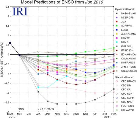
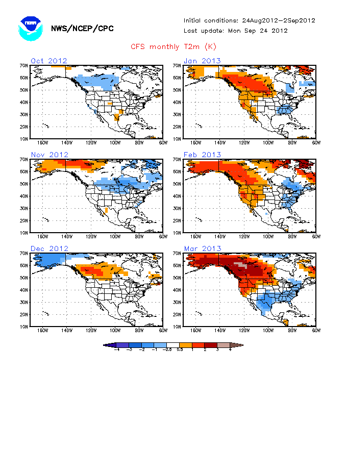
These graphics are from the cpc and noaa. As you can see  a transition to a moderate la-nina is likely in the coming months. Some analog years for a winter match up well with a transition from el-nino to la-nina, 95-96, 98-99, 88-89 and 07-08. 95-96 was  cold with lots of snow compared to normal while 98-99 had little snow and was very mild. A common occurrence is for a cold December in la-nina years a look at the cfs climate model above does show that potential.

The forecast for this weekend is below in the comments section or can be found @ http://people.wku.edu/leeperd/

Posted in Kentucky Weather | Comments Off on weekend forecast and a winter preview

Another heavy rain threat around the corner???

1. Wednesday we had a frontal boundary move further south than expected with the last forecast update into the region at the same time a band of thunderstorms developed just south of the boundary which moved very slowly and west to east across the region resulting in flooding in particular for areas just north of Bowling Green. Today and Saturday a ridge of high pressure will break up and send the boundary northward leading to hot and muggy weather ( 90’s for highs and low 70’s for lows and heat index values of 100-105). Make sure to keep in this mind if outdoors as a heat advisory is in effect.

2. Tropical depression Bonnie is located just south of Tampa,Florida tonight and is expected to move northwest into the gulf making landfall early next week near New Orleans. This system looks very week now with the likelihood of becoming a storm again not that great sue to an unfavorable position of the upper level low and increased shear near it’s path. The moisture from Bonnie should move north into our region by Tuesday. At the same time another front will push south through the ridge enough to make it into the lower Ohio valley before stalling and weakening over our region. The combination of these two systems will lead to likelihood of afternoon and evening showers and storms with a heavy rain threat. Right now this front& tropical leftovers should be over the region with thunderstorm chances from the front on Sunday entering the region and the tropical moisture addition for Monday through Wednesday. Highs should be in the low 90’s Sunday and in the mid to upper 80’s Mon-Wed thanks to clouds and storms with lows from 66-72. Continue reading

Posted in Kentucky Weather | Comments Off on Another heavy rain threat around the corner???

More Active Start to Week

1. The pattern for this week will be a stationary boundary to our north and northwest with our region on the eastern edge of the summertime  ridge.  The boundary will move back and froth through the week when it close thunderstorms chance increase when it’s further north it’s hot and humid. Continue reading

Posted in Kentucky Weather | Comments Off on More Active Start to Week