Beware of Dangerously Low Wind Chills

Good afternoon, everyone! We hope that you are making the most of the university’s snow days!

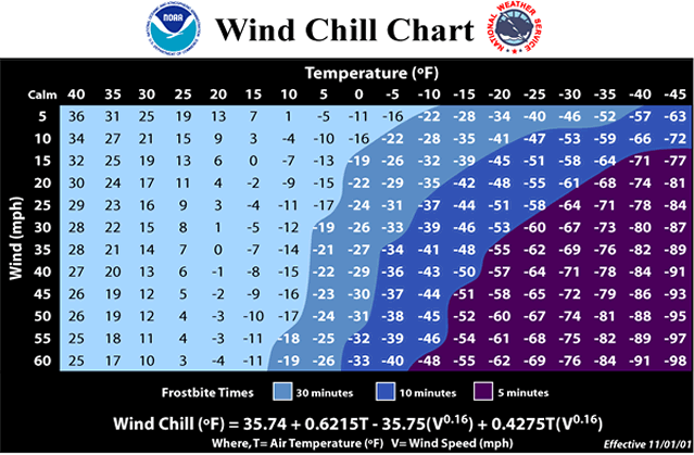
Today, we will have a break from that wintry mixture that we’ve had so far this week. However, wind chills will be in the single digits for the entirety of today and into tomorrow morning. If you plan on being outdoors at all today, we advise that you layer up to cover as much skin as possible to avoid any health risks. For tips on how to prepare for cold weather, click here.

(National Weather Service)

Stay warm! We hope that you have a wonderful rest of your week!

Posted in Kentucky Weather | Comments Off on Beware of Dangerously Low Wind Chills

ALERT: Winter Weather Advisory

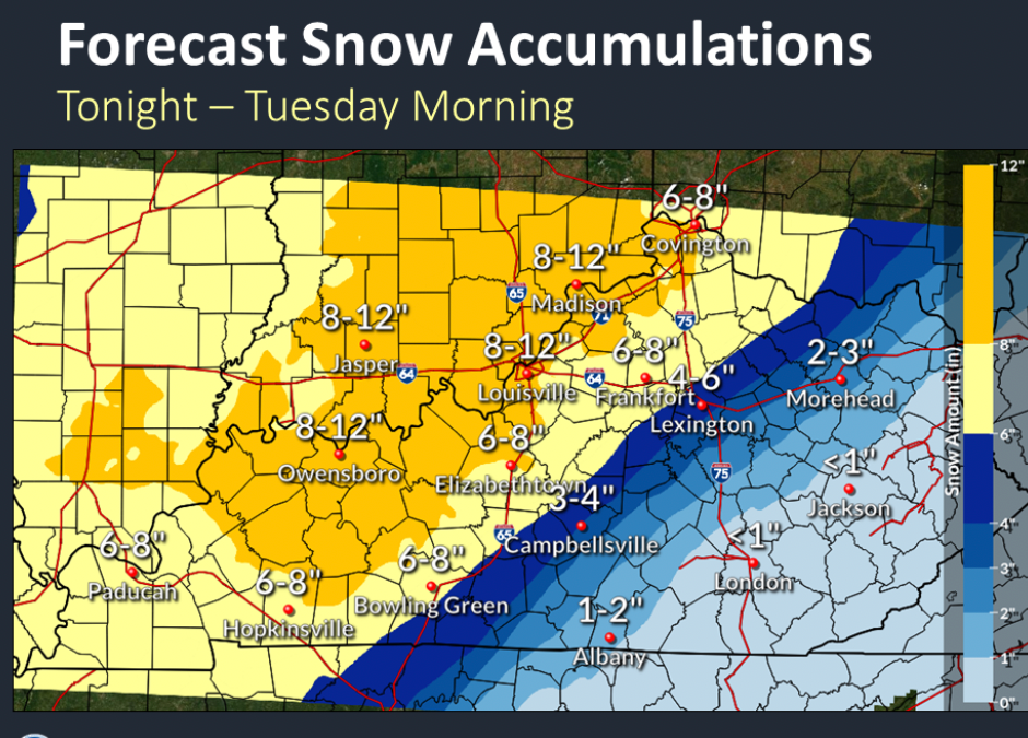
The National weather Service has issued a winter storm warning for all of Kentucky. Two waves will be expected, making travel on Monday extremely dangerous. About 6-8” are expected by them, which is what most models are saying as well. The most impactful timeframe for snowfall is expected to be from 2pm Monday into 1 am Tuesday. About .01-1” of ice is also expected. The high for Monday is 25F and the low is 12F, so definitely stay bundled, but try to stay out of the roads if possible! Transportation efforts will be severely impacted. Sheets of ice on roads with temperatures in the teens will make roads/highways extremely dangerous, slick, and slippery. Snow accumulations will only add to this threat. Commuting anywhere is not advised unless absolutely necessary

Courtesy: https://www.weather.gov/lmk/

Stay safe!

Posted in Kentucky Weather | Comments Off on ALERT: Winter Weather Advisory

A short break from the wintry mix!

Mostly cloudy skies are in for the start of your Friday with a high of 38F. Upper level troughing will encourage temperatures to drop as freezing rain will make its way through the region between midnight and 5am heading into Saturday. The wintry mix returns on Saturday as we expect this potential to increase throughout the morning. Though accumulations will be minimal, please keep an eye out for slippery road conditions as you commute. Afterwards, mostly cloudy conditions are going to take place. Expect a high of 33F and a low of 17F. Overall, temperatures seem to be on the decreasing trend to start the weekend off. Definitely keep that coat around and stay warm!

Posted in Kentucky Weather | Comments Off on A short break from the wintry mix!

The Aftermath

Good morning to you! We hope that you are staying in and staying warm at a time like this!

If you are a fan of the Kentucky Mesonet, you may have noticed something off by the wind speed map. A vast majority of the counties read 0 mph winds.

So, what is the reasoning behind this?

Whenever this happens, it is a good indicator that the area of interest has received a significant amount of ice because the anemometer (the instrument that measures the wind speed) is frozen. For this to happen, about 0.2 inches or more of ice must be accumulated. This was something that I learned in a class today, so I thought I’d share.

Because of this, we would like to remind you to travel with extreme caution today if you must be on the roads. We won’t see temperatures exceed much over freezing today, so any ice on untreated roads may stick around longer than we’d hope for. As the National Weather Service says, “ice and snow…take it slow!”

Posted in Kentucky Weather | Comments Off on The Aftermath

Ice Storm Warning!

Prepare for wintry mix conditions to set place as a low pressure system dominates the southeast. Rain showers will start this off by this morning with a high of 39F before transitioning into a wintry mix by your afternoon. The low will be 29F, but wind chill index will drive those feels like temperatures down to the teens. Thus, bundle up if you plan on being out and about and definitely bring those plants and pets in for the day. These cooler temperatures will aid in the snow/sleet to stick to the ground better, so this will also have some transportation impacts. The wintry mix potential and expected accumulations increase as we head into Thursday, so definitely stay with us as we continue to forecast this for you.

Stay safe and have a good day!

Posted in Kentucky Weather | Comments Off on Ice Storm Warning!

Significant Icing Anticipated for South Central Kentucky

Good morning to you! We hope that you are having a wonderful day so far!

If you haven’t seen already, the south central region of the state is under a winter weather watch for tonight into Thursday evening. Here, we will give you a rundown on this event so you’ll know what to expect.

On Wednesday, we will start out with scattered showers that will transition to widespread freezing rain overnight and into Thursday. As of now, anticipated precipitation totals range from 0.25-0.75 inches. According to the National Weather Service, power outages and tree damage will be likely because of the ice and travel could be “nearly impossible”.

Moreover, the wind chill is likely to remain below freezing throughout the entirety of this event. We may see values start in the upper 20’s at the start of Wednesday that will drop to the lower 20’s into Thursday and remain that way into Friday. Therefore, we advise that you layer up accordingly to stay safe!

That’s all for today! Please be mindful of this event and do spread the word! Stay safe!

Posted in Kentucky Weather | Comments Off on Significant Icing Anticipated for South Central Kentucky

Sunny but Chilly!

Partly sunny conditions for the majority of the day as South Central Kentucky sits under a high pressure system. The high for today will be 47F and the low will be 34F. There is a possibility of some showers rolling in through the late night, so prepare for that if you will be traveling tonight. Right now it’s looking like that will happen after 3am. Overall though, dry and cold conditions will dominate the start of your week before a warm front comes through by the afternoon to increase temperatures a bit.

The rest of the week looks wet! We’re keeping a close eye on a wintry mix that’s looking to roll in by Thursday. Have a good day and stay safe!

Posted in Kentucky Weather | Comments Off on Sunny but Chilly!

Clear but Chilly!

Clear skies with dry conditions will dominate your Friday as a high pressure system takes place over the Louisiana and Arkansas border. This high pressure system will bring cooler temperatures and dry air with it, so bundle up if you plan on being out and about. The high for today is 43F and the low is 28F. Other than that, take advantage of the dry start to the weekend because we’re looking at a wintry mix possibility on Sunday along an incoming stationary front! Keep that coat around.

Enjoy your weekend and stay safe!

Posted in Kentucky Weather | Comments Off on Clear but Chilly!

Rain Today Leads to a Sunny Weekend

Good morning to you! We hope that you are having a great week and that you are staying warm!

Today, a low pressure system will be moving through our region, bringing about a brief disturbance. A cold front will bring about widespread showers that look to start late morning to early afternoon. We may only see precipitation totals reach a tenth of an inch, though, so these showers will be numerous but lacking any intense amounts of rainfall. On the other hand, there is a threat for gusty winds this afternoon and into tonight. According to the National Weather Service, gusts of 30-35 mph are expected, though 40 mph can’t be ruled out. With that said, please be cautious if you plan on being in your car in the evening.

Tomorrow, sunny skies will return and they are anticipated to remain this way for the entirety of the weekend. Get outdoors and enjoy yourself! That’s all we have for you today!

Posted in Kentucky Weather | Comments Off on Rain Today Leads to a Sunny Weekend

A Break From the Gloom to Come

Good day, everyone! We hope that you are having a wonderful start to your week and that you are making sure to stay bundled up!

Today, we saw a gradual decline in cloud cover, which offered a preview of what’s to come. Tomorrow, there won’t be many clouds in the sky at all. This will be the least amount of cloud cover that we will have for the rest of the week, so make sure you spend some time outdoors! Furthermore, temperatures will be warmer tomorrow, reaching the lower 40’s. Although winds will remain frigid, they will not be as pronounced as they were today.

Thank you so much for reading! Stay warm!

Posted in Kentucky Weather | Comments Off on A Break From the Gloom to Come