Rain on the Way

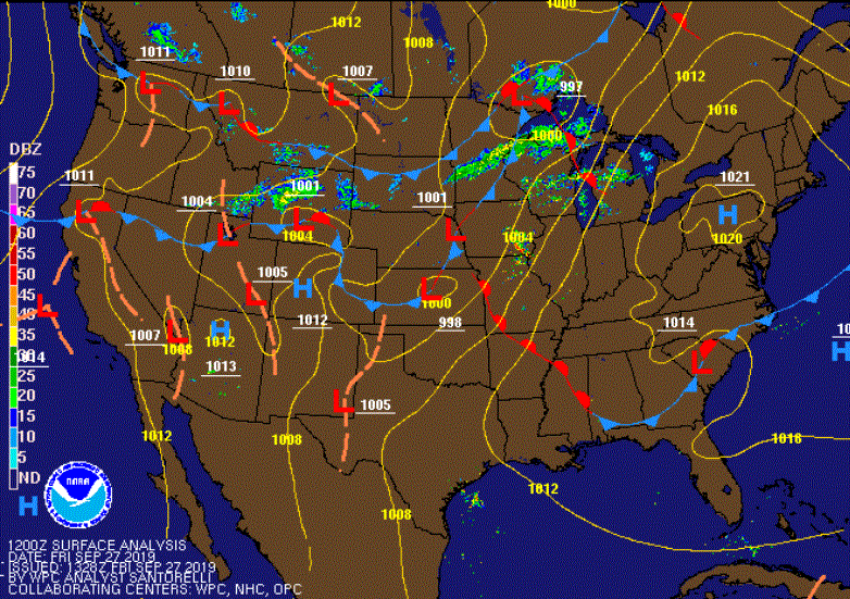
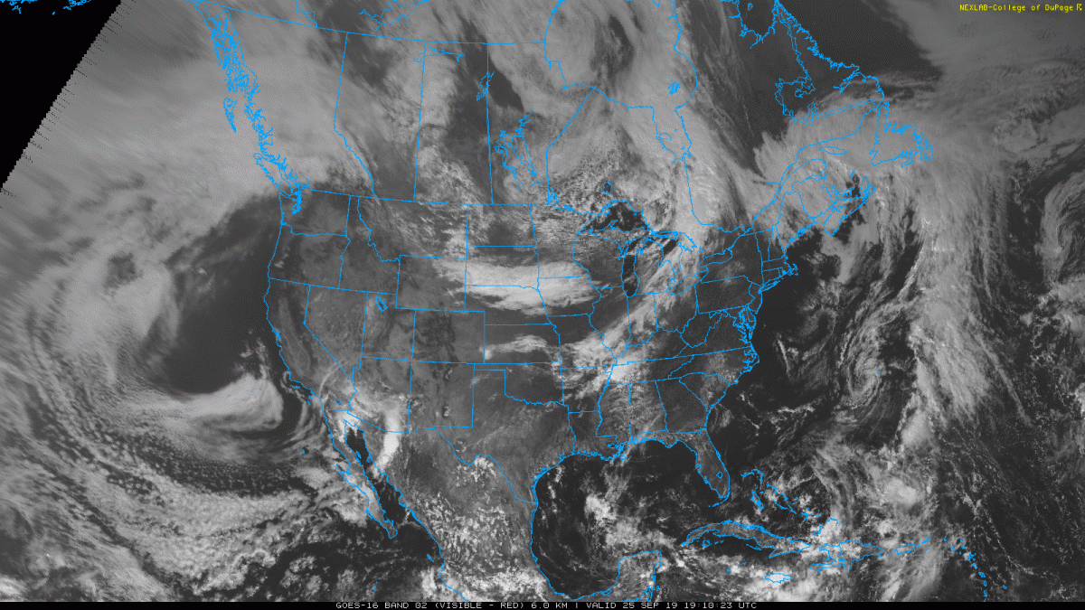
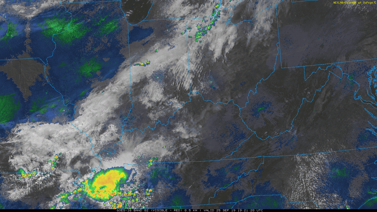
After a really nice day, we’ll end it with some wet weather tonight. Expect showers and thunderstorms to move in just before midnight tonight and stick around through the early morning hours. Rain totals will vary depending on where those thunderstorms track through the region producing heavy downpours for some. Most people can expect a quarter to a half inch of rain, but those in the heaviest downpours could see upwards of an inch tonight. October is typically the driest month of the year, but the recent rain has helped lift the burn ban for nearly every county in SOKY. Tonight’s rain will keep us out of the burn ban, but don’t forget that there is still a seasonal burn ban from 6AM-6PM through December.

Besides a very slight chance for a rain shower before the morning rush hour, Wednesday will be much drier, clearer, and cooler than Tuesday. Bowling Green will struggle to make it into the 60s, but as skies clear throughout the day, the additional sunshine should get us there. It’ll be breezy with winds out of the NW at 10-15mph. It definitely looks like the perfect day for sweats and a hoodie as you’re heading to classes on the Hill tomorrow. Keep in mind that the windy conditions could mess with the Homecoming Games at the Colonnades tomorrow afternoon especially if there are any events that involve throwing items back and forth.

Thursday will be a clone of Wednesday afternoon minus the windy conditions. Cool and sunny once again!

It will be nearly perfect weather for the students that are walking in the parade on Friday! Don those Homecoming sweatshirts/long-sleeved shirts and chant away for Dear Old Western and your favorite organizations as you walk alongside everyone that made it such a special week! Sunny skies and temps near 70 will make for a beautiful and comfortable walk to and from the Downtown Bowling Green Square.

Tonight: Low of 50 and High Chance of Rain.

Tomorrow: Skies clearing as the front moves East in the morning. High temp of 62 with windy conditions.

Tomorrow Night: Low of 38 with Clear Skies.

Thursday: High of 62 and Sunny, but temps will drop into the middle 30s before Friday morning.

Posted in Kentucky Weather | Comments Off on Rain on the Way

Weekend Weather Woes

Besides a very slight chance for a pop-up shower or storm today, weather conditions will be ideal for the first full day of Fall Break here in Bowling Green. Highs will be right around 80 with partly cloudy skies. If you have time, go enjoy a nice adventure with family or friends at Jackson’s Orchard on the North side of town!

Tomorrow will be a totally different story as a system moves through the area. Expect showers and storms to start during the mid-afternoon hours and carry on late into the night. Southerly winds will warm us up ahead of the afternoon storms, so you will get at least one more chance to wear a short-sleeved tee this year before donning the rain jacket for the rest of the day. High temps will hover in the low 80s. Expect less than a quarter of an inch of total rainfall Friday and Friday night.

By sunrise, showers will be east of I-65, so Bowling Green residents won’t have to worry about poor road conditions Saturday. We will have to bundle up though, considering the cool, dry air behind the cold front will keep our high temps in the low 60s. WKU’s football game against Army will be cool but dry and hopefully end in another Hilltopper win!

Sunday will remain cool, but not unseasonable for this time of year. We will have our first chance at patchy frost because of the moisture from the rain on Friday along with the cold temps Sunday morning. Expect to wake up to sub-40 degree temperatures and mid 30s for areas outside the city limits. We’ll warm up nicely to 70 degrees, so you can probably shed that heavier layer needed earlier in the morning.

Posted in Kentucky Weather | Comments Off on Weekend Weather Woes

Fall Break Plans

As many WKU students leave for Fall Break today, it will be important to know the forecast for the area you’re heading to for the next 4 or 5 days. Here’s a quick summary of some typical vacation hot spots for college students.

Panama City Beach: Temperatures will be in the upper 80’s today through Sunday with partly cloudy skies each day. Besides the very slight chance of a stray shower this afternoon, today looks like the perfect way to start off a trip to the beach. The next and more likely chance for rain comes Saturday. It won’t be a wash out by any means, but be aware that a thunderstorm could keep you in the hotel room for a couple hours.

Colorado: If you are heading to Denver, things are going to get dicey here quick! Today’s high will feel like a nice summer day with temps in the low 80s, but a cold front moving through tonight will give us a plateful of winter. Temperatures will be dropping into the mid-20s with freezing drizzle and snow likely. Tomorrow might not even break into the 30s, and snow accumulations could amount to upwards of 3 inches. Friday start off very cold with temps in the teens and stay cool with highs only in the upper 40s. Things will start to warm up in Denver with Saturday and Sunday both reaching into the 60s. Sky conditions will be mostly clear once the system moves out Thursday night, so at least it will be pretty!

Coasts of North/South Carolina: Rain won’t be a threat for beach-goers in either state until late Sunday. By that time, most students will already be heading back to campus. Temperatures will vary along the coast. Expect upper 60s for highs in places north of Cape Hatteras, NC. Anyone between Cape Hatteras, NC and Myrtle Beach, SC can expect highs in the mid 70s each day. Farther south toward Hilton Head, SC, things will start to heat up as temps peak in the low 80s. Water temps will be between 75 and 80 degrees from north to south along the coast.

Finally, if you are staying in Bowling Green, temperatures will vary greatly especially as the weekend approaches. Today will be nice with partly cloudy skies becoming mostly clear and highs in the upper 70s. Tomorrow and Friday will both be in the low 80s, but rain will come into play Friday evening. Rain looks likely overnight Friday into Saturday, but the football game against Army at 7pm CT will be dry. On the other hand, temps will drop by 20 degrees between Friday and Saturday’s highs as Saturday barely make sit into the low 60s. Sunday will be cool but pleasant as highs warm back up into the upper 60s with mostly clear skies making for a great day to wear the flannels and jeans and head to a local pumpkin patch or orchard!

Posted in Kentucky Weather | Comments Off on Fall Break Plans

Great Weather In The Forecast

Today was cool and wet, the Ky Mesonet site in Bowling Green recording 0.77 inches of rain and a high temperature of 65°F today. The rain, and clouds for that matter, have sense moved out of the area and it will remain dry for the rest of the night, as temperatures drop into the mid-40s by Tuesday morning.

Tuesday is looking to be a great day as we will remain dry, and the high temperature will climb back into the upper-60s under sunny skies. Tuesday night will be cool and dry, with a low around 50°F by Wednesday morning.

Wednesday will again be sunny, as the temperature returns to the low 70s by mid-afternoon. But fear not, Wednesday night will again be cool as the temperature drops back into the low-50s in a typical fall fashion.

Posted in Kentucky Weather | Comments Off on Great Weather In The Forecast

Cold front

We finally will start feeling cold due to cold front passing the area during this day. The high temperature will be lower 80 °F and sunny with some scattered high clouds. It is a perfect day because people could walk without feeling hot. I remember one-woman last week in Owensboro`s Smothers Park, she said to me “definitely, there is no Fall this year”. I could see her when she was sweating while she watched her children play in the playground and she was unhappy about her situation. I believe that this woman will change her main after few days.  

Figure1: surface temperature from Mesonet as 9:50 AM

The ridge over Kentucky will continue moving to east as a cooler and dry air dips the low temperature on Saturday morning to mid and upper 40s with some exception in some area with above 50s. therefore, Saturday will be calm since the ridge is dominated over Kentucky but Sunday is another story. A line of storms will be observed over Ohio River and Tennessee Valley until early morning on Monday. This is because a strong upper trough will cross the area at that time. The trough will enhance the lifting across the region and then will give chance of shower and thunderstorm.  I think everybody in Bowling Green are waiting for rain therefore, there will be a significant amount of rainfall on Sunday. Figure 2 shows the forecast of precipitation amount over our area.   

Figure 2: Total accumulation of precipitation for next 2 days and a half from GFS.

Summary

Day Sky High (°F)  Low (°F)
Friday night Mostly Clear     53
Saturday Sunny 87  
Saturday night Mostly clear then chance showers   63
Sunday Chance showers then showers 80  
Sunday night Showers   53

Posted in Kentucky Weather | Comments Off on Cold front

Fall is on Its Way

The past few days have been sweltering! We set another couple records: 98 on Wednesday and 97 on Thursday. Both of the previous records were crushed. And after the 4th straight day with a record high temp, we will finally start to cool off. The cold front that just passed through will bring us dry and cool condition for Friday. Temperatures will be right around 80 degrees with mostly sunny skies and dew points will be in the lower 50s. It is literally a perfect start to the weekend! Get out and Eno or enjoy a walk in the park if you are able to do so.

Saturday will be warmer as temperatures bump back up into the upper 80s. Winds will turn from NE to S during the day bringing more warm air into Southern Kentucky.

Sunday will be totally different. We are finally introducing a chance for significant rainfall into the forecast! A line of storms will move through the Ohio River and Tennessee Valleys late Sunday into early Monday morning. NAM and GFS both point to rainfall amounts of more than 1.5 inches. Whatever amount of rainfall we get, we need it! Every county surrounding Warren County by about 50 miles is in moderate to severe drought. Therefore, they are all under a burn ban.

By the time the rain moves out during the first half of Monday, nice, cool, dry air will move into our region. The start of next week will feel exactly as Fall should feel: temperatures will be in the low 70s and skies will be mostly clear. So get ready for pumpkin-pickin’ weather for the few days before Fall Break begins!


Posted in Kentucky Weather | Comments Off on Fall is on Its Way

Records are Falling

The entire month of September has been HOT! In fact, we tied the all-time record from 1939 for 90 degree days in September with 22 total. But the Summer heat has decided it wants to stick around for the beginning of October as well. Just like yesterday’s record setting 97 degree temp, we broke yet another high temp record today topping out at 97 again. The record for October 1st was 93 degrees and was set back in 1926. This also breaks the all-time high temp for the entire month of October. In summary, September ended in record breaking fashion, and October has started off the same.

Tomorrow will be a clone of what we experienced today: we’ll start off around 70 in the morning and peak with highs in the upper 90s. I can easily see us hitting 97 once again due to how dry the ground is and the southerly wind flow bringing in plenty of heat.

Thursday will again start off warm in the upper 60s. The timing of the cold front – which has been dumping rain across the Great Plains – will be instrumental in determining our high for Thursday. If it speeds up like the NAM says it will, then our high will be around 87; however, I think the GFS’s depiction of a slower moving front will allow just enough time for us to pop into the low 90s one more time. Once the front moves through Thursday evening, we’ll see temps take a quick dive to near 60.

Friday will be beautiful: highs near 81 and clear skies for miles around. So let’s get through these next couple days and get ready for a great start to the weekend!

Posted in Kentucky Weather | Comments Off on Records are Falling

The Autumnal Equinox

   On this astronomical occasion, it is good to talk about autumnal equinox here in Bowling Green. The autumnal equinox has already occurred in this city on Monday, September 23, 2019 at 2:50 am CDT when the daytime and night are almost equal. The astronomical explanation for this event is when the sun’s disk is perpendicular to the equator and the length of day and night is nearly equal. After this moment, Astronomically, the autumn or fall begins in the Northern Hemisphere of the globe and the first day of this season starts. But in Southern Hemisphere is the beginning of Spring or sometime is known as the vernal. 

Figure 1: The movement of the Earth around its axis and its rotation around the Sun (NWS)

    Turing to the weather in Bowling Green, the temperature is about 84 °F and dew point is 72 °F. We could see today the high temp reach to 92 °F since it is sunny day with some high clouds.  A high pressure will move toward “Southeast” because a weak cold front will be pushed into Mississippi Valley and Great Lakes. Therefore, we will feel a worm temperature coming back because of breezy southerly wind that is between these two system.

Figure 2: The current surface map is showing the cold front location (NWS)

The cold front during tonight will not move too much to eastward, thus a dry situation will be dominated the condition in Bowling Green but a south breeze will drop the low temperature in the 65 °F.  generally, it seems we will continue with dry condition and the driest September on record with less than quarter inch of precipitation.

Summary for next few days  

Day High (°F) Low (°F)
Tonight (Mostly clear)   68
Saturday (sunny hot) 95  
Saturday night ( Partly cloudy)   68
Sunday (sunny hot) 94  
Sunday night (Mostly clear)   69


Posted in Kentucky Weather | Comments Off on The Autumnal Equinox

The Heat Returns… With a Vengeance!

Well, the break from 90s and high humidity was nice while it lasted. With temps in the 80s (barely even making 80 today) and dew points in the 50s recently, we finally got the long awaited relief that many of us have been searching for. We even got another 0.07″ of rain this morning! The past few days were the closest thing we have seen to Fall weather yet; however, that will soon be gone as Friday rolls around.

With the light rain showers that rolled through this morning, we are now officially the 4th driest September on record with 0.21″ for the month. Even with those light showers this morning, we are still far in the deficit for this month. Therefore, there is still a burn ban in effect for nearly every one of the South Central Kentucky counties. That means individuals can’t burn trash, leaves, or have any sort of outdoor fire. And with the mid-90s making a return by the beginning of the work week, the burn ban will likely remain in place for the next couple weeks.

Tonight, temperatures have already dropped into the 60s and will continue dropping down to 58. Clear skies will make for quite a beautiful night after a wonderful sunset a few hours ago.

Tomorrow, we will be back into the low 90s with humidity returning.

The weekend will really start to heat up with morning lows near 70 each day and highs at 92 and 93 Saturday and Sunday respectively.

Monday will be very hot. A forecast temp of 94 will be just 1 degree off the record high for September 30th. Tuesday will be even hotter: if we hit the forecast high of 95, we will set a new record for the first day of October.

It’s safe to say that summer still has Bowling Green in it’s suffocating grip. Fortunately, as long as people just put up with this next week of extreme heat, things will start to calm down and move a little closer to the norm for this time of year. In the meantime, stay hydrated, get your final swims in, and be safe South Central Kentucky!

Posted in Kentucky Weather | Comments Off on The Heat Returns… With a Vengeance!

Sweet Relief!

I went out this morning to a sound and a feeling that had been long lost: rain! Temperatures already started to feel much better yesterday after the cold front had made its way through the area. Dew points have dropped from the upper 60s and 70s down to the 50s. Right now we are sitting at 85° with a dew point of 53°.

There is another cold front getting ready to cross the area associated with a low pressure center and cyclogenesis in Canada.

There are some showers and storms at the bottom tip of the front that will make their way into the area later this evening.

Rain chances will continue through tomorrow before clearing out for Friday. With the rain and the second cold front coming through temperatures will remain around 85 today but will drop to around 82 tomorrow. After the rain clears up temperatures will go back up to around 90° for Friday.

  • SUMMARY:
    • Wednesday:
      • High: 85
      • Low: 55
      • Rain chances will increase later into the night.
    • Thursday:
      • High:82
      • Low: 53
      • Make sure to keep your umbrella available!
    • Friday:
      • High: 90
      • Low: 69

Have a safe, great weekend!

Posted in Kentucky Weather | Comments Off on Sweet Relief!