Off to a Wet Start on the Autumnal Equinox

Surface Map 10Z (Source: College of DuPage)

It is the first day of autumn, where the world gets an equal amount of sunlight, and with the recent passing of the cold front, it is going to feel like it, too. However, rain isn’t out of the question despite such. A strong cyclonic system within Texas will push in more instances of precipitation to start our morning, and wet conditions will continue into our afternoon, and into our evening.

13Z GOES-16 Satellite Image (Source: College of DuPage)

12Z HRRR Reflectivity (Source: College of DuPage)

The map above suggests that it will rain all day. With this in mind, expect wet conditions over a long period; any time you need to go out, be sure you bring an umbrella or a rain jacket to keep you dry.  With the recently passed cold front and the rain, temperatures won’t get really high; expect temperatures that can get up to the low 70’s and upper 60’s.

21Z SFC Temperature (Source: College of DuPage)

Summary:

Saturday: 90% chance of rain throughout the day and into the evening; High: 73, Low: 65

Sunday: 60% chance of showers, otherwise cloudy; High: 71, Low: 63

Monday: 60% chance of rain; High: 77, Low: 67

Posted in Kentucky Weather | Comments Off on Off to a Wet Start on the Autumnal Equinox

Evidence of a Cooler Trend

Greetings!

On Friday, 9/21, the weather will start out warm and muggy with the high pressure over North and South Carolina swinging gulf moisture into our area. This moisture is colliding with the cold front currently north-east of Kentucky and is kicking off storms in portions of the Midwest.

That cold front is set to arrive in Kentucky in the late afternoon into the evening hours. The HRRR is showing storms reaching western Kentucky around 17z, 12 pm central time. But not reaching central Kentucky till around 20z, 3 pm. There are some trends in different molds showing the system weakening and then strengthening again once it reaches lower Ohio valley.

(Disclaimer: models are used to get an understanding as to what might happen, not this is going to happen right then.)

13

This looks to be the start of a wet weekend. There are some indications showing that our area will be hit with a couple rounds of rain and storms through-out the weekend into the beginning of next week.

This will bring cooler temperatures into Kentucky behind that cold front.

The high today will be around low 90s with the high of Saturday being around the low 70s. As of right now it looks to stay around low to mid 70s for the majority of next week with a little warm up around Monday and Tuesday then back into the 70s.

In summary:

Friday: 90/66

Saturday: 70/64

Sunday:74/67

With chances of rain all weekend, starting Friday late afternoon.

Posted in Kentucky Weather | Comments Off on Evidence of a Cooler Trend

Rain and Cooler Temperatures on the Horizon

Good Afternoon!

It has been quite a toasty one out there today thanks to a upper level ridge centered over the Tennessee River Valley, but an active weather pattern and cooler temperatures are on the horizon. High temperatures for today will top out around 94° with a heat index right around the century mark, 100°. Skies will be mostly clear for the rest of the day with the exception of a few scattered clouds. Tonight will be on the warmer side with lows hovering in the lower 70s with mostly clear skies.

Below: 20Z Thu 2018-09-20 HRRR 2m Temp (°F)/ 10m Wind (Kts)

Tomorrow will be very similar to today, except for increasing cloud cover later on in the day thanks to a strong area of low pressure over the northern Great Lakes and eventually moving into the Canadian Province of Ontario tomorrow. The area of low pressure will drive a cold front southeast into the Ohio River Valley. With a lot of moisture and instability in place ahead of the cold front, shower and thunderstorm chances are not out of the question later in the day as the cold front approaches the area. Temperatures tomorrow  will top out around 90° with increasing cloud cover and scattered showers and thunderstorms in the late afternoon and evening hours. Scattered showers and thunderstorms will linger into the overnight hours with a low around 67°.

Below: 21Z Fri 2018-09-21 NAM 2m AGL Temperature (°F)

Rain chances stick around for the first half of the weekend on Saturday. A weak shortwave across the southern Great Plains will exit and make its way across southern Kentucky and northern Tennessee. Temperatures on Saturday will be cooler with highs across Warren County topping out in the middle 70s.

Below: 18Z Sat 2018-09-22 NAM Surface Temperature Anomaly (°F)

Forecast:

Tonight: Mostly clear skies, with a low of 71°. Calm winds out of the south.

Friday: Mostly clear skies throughout the morning into the early afternoon with increase in cloud cover with scattered showers in thunderstorms, high of 90°. Winds out of the southwest at 5-10 mph with gusts reaching 20 mph.

Friday night: Showers and thunderstorms are likely with cloudy skies, low of 67°. Calm winds out of the north.

Saturday: Chance of showers and thunderstorm with cloudy skies, high of 75°. Winds out of the northeast at 5-10 mph.


Posted in Kentucky Weather | Comments Off on Rain and Cooler Temperatures on the Horizon

Summer Takes a Final Stand

Happy Wednesday!

Temperatures are back in the lower 90s yet again, as Summer continues to hold on tightly.  As the first day of Fall approaches this weekend, when will actual Fall-like temperatures will begin?

Unfortunately, it seems that Summer is taking a final stand over at least the next week.  Unseasonably warm weather is forecast across the United States over the next seven days, as the jet stream is kept to our north and a Summer-like pattern is withheld.  With warm temperatures and high humidity expected, it is important to drink plenty of fluids and limit your time outdoors under direct sunlight.

Finally!  As we look to the 8-14 day outlook, there is hope past the next week for cooler temperatures.  Models are indicating a dip in the jet stream, bringing more Fall-like conditions.  It is too far out to speculate on specifics, but it is possible with this change in pattern that parts of the U.S. could see severe storms.  Simply something to keep an eye on after this next week.

Today: Isolated showers and storms, high temperature of 91

Tonight: Partly cloudy, low temperature overnight of 70

Tomorrow: An isolated shower or two, high temperature of 92

Posted in Kentucky Weather, U.S. Weather | Comments Off on Summer Takes a Final Stand

Back in the 90’s… Again!

Good afternoon!

Hotter temperatures this week will make you think, is summer weather ever going to end? Well, with autumn equinox approaching on Saturday 8:54PM CDT, summer is looking to give it all he’s got before then. High temperatures go from mid 80’s with light rain to a scorching mid 90’s through Thursday. So whats the blueprint? The Mid-South region received predominant southern moisture over the past couple of days correlated with low-leveled tropical storm Hurricane Florence. This airflow moved northeastward as a high pressured zone moves into our region increasing temperatures to low 90’s for the next few days. Therefore, an abundance of Sun along with a slight northward wind at the surface will be suitable for convective activity throughout the day.

NAM guidance for MSLP and 10m winds in knots (courtesy of PivotalWeather) 

This is key towards the increase of clouds and will indeed produce a valid, but slight risk for a few scattered showers throughout this afternoon into your evening hours. Today conditions are summer-like and slightly humid. However, not too bad of a feeling due to that slight north wind around 5 mph. Dew points will level out to the 70 mark around sunset inducing partly cloudy skies tonight. Wednesday starts out with slight cloud cover for temperatures will be a close call to 90 degrees due to that absorption of radiation by various cloud cover.

Average total cloud cover in a NAM mod. guidance (courtesy of COD)

Here’s my forecast…

TODAY: Mostly sunny skies with gradual increase in cloud cover to scattered clouds. High temperature at 92 degrees.

TONIGHT: Partly cloudy skies with a slight chance for scattered rain showers in the evening hours. Low temp in the lower to mid 60’s.

WEDNESDAY: Mostly sunny, temporal clouds with a high temperature of upper 80’s (could reach 90). A low temp in the mid 60’s.

Posted in Kentucky Weather | Comments Off on Back in the 90’s… Again!

When Will Fall Begin?

While Florence dumped an absolute deluge of rain on the East Coast, Bowling Green officially received .13 inches from rain associated with the remnants of the hurricane. As the post tropical system moves out, high pressure will begin to move in by mid-week. Another very slight chance for rain around the dinner time hours tomorrow will be the last for the next few days. And as the rain goes away, the mercury will take quite the leap with temperatures soaring yet again into the low 90s. While it is already meteorological Fall and will officially be astronomical Fall in just a matter of days from now, don’t be fooled. Prepare for conditions equivalent to the dog days of summer.

Low pressure moving out, high pressure building in

0Z Tuesday NAM Valid from 12Z Tuesday to 6Z Thursday- Courtesy Pivotal Weather


Things will be heating up on Wednesday as seen below

0Z NAM valid for 21Z Wednesday (3pm CDT)- Courtesy Pivotal Weather

With a lack of clouds and very weak winds on Wednesday and Thursday, there won’t be any relief from the heat. Dew points will be in the upper 60s to low 70s throughout the week. Any outdoor activities should be done with caution especially if they are strenuous. Stay hydrated and take frequent breaks.

To recap:

Tuesday: Slight chance of rain, mainly around the early dinner time hours. High of 90 with partly sunny conditions. Winds will be light out of the West then North later in the day.

Wednesday: Partly cloudy with a high of 91. Wind will again be light.

Thursday: High of 93, with clear skies allowing plenty of opportunity for a real heater of a day.

For now, those pumpkin spice lattes will be the closest thing any of us will get to that Fall-feelin’. The flannels and orchard visits will have to wait a little while longer.


Posted in Kentucky Weather | Comments Off on When Will Fall Begin?

A Wet Start to the Week

Friday September 14 Hurricane Florence made landfall as a category 1. There are parts of North Carolina now flooded with 10 feet of water. We continue to think and pray for those affected by the storm.

GOES 16 Satellite Images of Tropical Depression Florence

Hurricane Florence has now transitioned into a Tropical Depression and is making its way towards Eastern Kentucky where it will sweep up towards the Northeast. Bands from Florence will sweep across the western part of the state including Bowling Green.  While Bowling Green will receive rain, it won’t be much (less than a quarter of an inch).

GFS Total Accumulated Precipitation from Sunday through Tuesday

Unfortunately, the area will be muggy for the next few days as dewpoints stay in the 60s. Temperatures will continue in the low to mid 80s through Monday where it will then climb into the upper 80s and 90s to finish off the week.

SUMMARY:

Sunday will see a high of 84 and a low of 69 with showers in the afternoon.

Monday will reach a high of 81 with a low of 68 with showers and a chance for thunderstorms throughout the day.

Tuesday will reach a high of 87 with a low of 72. Skies will be clear with the exception of a few clouds left from Florence.

I hope everyone has a fun, safe week!


Posted in Kentucky Weather | Comments Off on A Wet Start to the Week

High Pressure and High Humidity for this Weekend

15Z Current Surface Map (Source: College of DuPage)

Days with high humidity aren’t days to look forward to, and this Saturday is no different. Currently, we’re looking at a muggy start to our late-morning and this won’t budge any time soon. A strong high pressure zone lies within Michigan. Dew points will stay well into the low 70’s and can fluctuate to the upper 60’s. Stay hydrated if you plan on prolonged outdoor activities.

Saturday: Sunny, warm and humid; High: 89, Low: 71

Sunday: Small chance of showers for the evening; High: 82, Low: 73

Monday: Sunny; High: 82, Low: 65

Posted in Kentucky Weather | Comments Off on High Pressure and High Humidity for this Weekend

A Peaceful Weekend Ahead

Greetings!

Friday, the 14th of September, looks to be a nice day with above average temperatures. The dew points will make it feel worse than it actual is. Dew points starting in the high 60s and going to the low 70s as the day progresses.

In BowlingGreen at 12z, 7 am Central Time, the temperature is at 72 with the dew point at 69. The high today will be about 88 degrees with the dew points about 71 degrees. As a result, it will feel muggy today.

Saturday it looks to be similar to Friday, with temperatures reaching about 89 and dew points around 72.

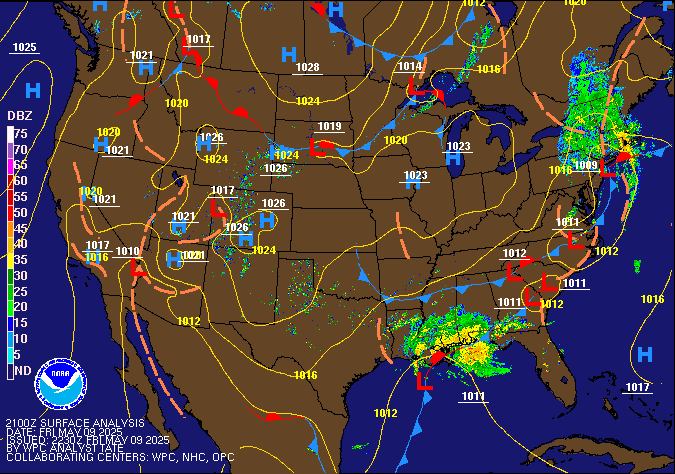
This warm weather has to do with the High pressure centered over Michigan.This high bringing the moisture from the gulf, which is causing  high dew points.

Current US Surface Weather Map

In Summary:

Friday: High around 88 with dew points maxing  around 71. With low  around 70.

Saturday: High around 89 with dew points maxing around 72. With the low around 71.

Sunday: High around 82 with low around 69 with a rain chance increasing through the night as remnants of Florence approach the area.


Posted in Kentucky Weather | Comments Off on A Peaceful Weekend Ahead

Summer-Like Temperatures for the Next Few Days

Summer-like temperatures and pleasant conditions will dominate the area Friday, Saturday, and Sunday. Temperatures for Friday will be a bit warmer than today as the center of an area of high pressure moves into the Ohio River Valley. Temperatures around Bowling Green tomorrow will top out in the upper 80’s with a mix of scattered clouds and sun.

Below: Fri 2018-09-14 18Z 500mb Temp/Height/Wind

Warm temperatures will continue into Friday night with lows around the area hovering right around 70 degrees. Some models are hinting at some early morning fog on Saturday. If you plan on hitting the roads early in the morning, don’t rule out running into some fog, especially in the low lying areas. Saturday’s forecast looks just as good as Fridays, temperatures will top out in the upper 80’s.

Below: Sat 2018-09-15 21Z 2m Temperature

Bowling Green Forecast:

Tonight: Mostly clear skies, low right around 70 degrees, can’t rule out morning fog especially in the low lying areas

Friday: Mostly clear skies with scattered clouds developing in the afternoon, high temperature will be in the upper 80’s

Saturday: Mostly clear skies with scattered clouds developing in the afternoon, high temperature will be in the upper 80’s

Turn to the Tropics

Hurricane Florence is an extremely dangerous and life-threatening storm that is slowing down on it’s approach towards the Carolina Coastlines.

Below: Official National Hurricane Center forecast cone, updated Thursday 11 PM EDT

This monster of a storm is going to produce extended impacts along the Carolina Coastlines and the interior portions of North and South Carolina. Heavy rain, damaging winds, and storm surge is what to expect. Even though Florence’s category has lowered, the wind field has grown massive in size. Inland flooding from feet of rain and up to 13 feet of storm surge is what to expect and will produce life-threatening conditions.

Below: NOAA/NWS/NCEP/WPC Rainfall Forecast, updated Thursday 4:51 EDT

The remnants of Hurricane Florence will be watched carefully over the next few days when the storm moves over land.

Posted in Kentucky Weather, U.S. Weather | Comments Off on Summer-Like Temperatures for the Next Few Days