Sunny Weekend!

southeast.vis

Good Afternoon Folks!

We have had some beautiful weather this week and we are wondering if it will continue. The image at the top is the Visible radar from COD. Showing that right now we just have a few clouds over our area. These clouds will persist for the rest of the day but will clear up as the night comes around. The model runs are showing the temperatures will be in the lower 80s today and tomorrow. We will have a little bit of wind from the south west which will make it feel a little mild out and about these next two days.

Now lets talk about our rain chances. Or lack of for that matter. namSE_sfc_prec_027sun

The only chance of rain the models are predicting for the next couple days is a slight chance for a quick shower along a cold front that will be passing thru mid day on Sunday. This cold front will bring the highs down for Monday. Lower 70s is what we could see for the most of next week. All in all, the rest of your weekend is looking like a great one!

Here’s your Weekend Forecast:

Saturday Night: Low of 68, Mostly clear, winds from the S at 5 to 10 mph.

Sunday: High of 83, partly cloudy, slight chance of a shower during the afternoon, clouds then clearing for mostly sunny near the evening, winds from the south west at 5 to 10mph.

More updates coming soon!

Posted in Uncategorized | Comments Off on Sunny Weekend!

Beginning Your Work Week

Temperature at the airport sits at 53 degrees at the moment. These fall like temperatures are going to stay with us for a couple of days but are going to slightly increase as we head towards the weekend. Here is the current surface analysis map.

surfaceanalysisgood

We have high pressure dominating our region at the moment and will continue to do so as the week progresses. We look forward into tomorrow where we will continue to have slightly overcast skies but no signs of rain. The clouds will start out partly cloudy and progressively become more potent as the day progresses. The forecasted high temperature for Monday is 80 degrees according to the National Weather Service which is a great start to the work week. Make sure you pack a jacket for your morning commute! Here is your final Monday workday forecast.

Bowling Greens Monday Forecast:

Monday Morning: Partly cloudy skies. Cool, low of 52 degrees with calm winds.

Monday Afternoon: Partly to mostly cloudy skies. High of 80 with a light breeze from the SW at 5-10mph.

Monday Night: Mostly Cloudy with temperatures entering the mid 60’s with a WNW wind of about 5-10mph.

Enjoy Your Monday!


Posted in Uncategorized | Comments Off on Beginning Your Work Week

Weekend Outlook

The current temperature in Bowling Green is sitting at 62 degrees, which is 13 degrees cooler than this time yesterday. The cold front, which is now situated to our south, is definitely being felt across the region this morning. This is the 24 hour change in temperature for the U.S.

sfc_con_24temp

The forecasted high temperature for today is 70 degrees, according to the National Weather Service. The average daytime high for mid-September is around 80 degrees, so the cold front brought well below-average temperatures for our area. We will continue to see these cooler temperatures into the weekend.

Today will remain cloudy with a northeast wind. There is a chance of rain this evening as an upper-level jet streak makes its way into Kentucky. This will provide enough energy for some possible scattered showers this afternoon into tonight.  A strong high pressure system currently in the central U.S. will beginning moving into the area tomorrow and Sunday, bringing sunshine and a slight warm-up until another cold front begins to move through early next week.

current

Take advantage of the cooler-than-average temperatures this weekend and start enjoying your Fall activities now!

Bowling Green’s Weekend Forecast:

  • Today: Scattered showers, mainly between noon and 4pm. Cloudy, with a high near 70. Northeast wind around 8 mph. Chance of precipitation is 30%.
  • Tonight: Isolated showers. Cloudy, with a low around 60. North wind 3 to 6 mph. Chance of precipitation is 20%.
  • Saturday: Partly sunny, with a high near 70. North wind 7 to 9 mph.
  • Saturday Night: Partly cloudy, with a low around 54. North wind 5 to 7 mph.
  • Sunday: Mostly sunny, with a high near 76. Northeast wind 3 to 6 mph.
  • Sunday Night: Partly cloudy, with a low around 56.


Posted in Uncategorized | Comments Off on Weekend Outlook

First Glimpse of Fall

Today and tomorrow we will see temperatures and humidity increase as we continue to have southerly winds bringing us Gulf moisture. A low pressure system is positioned over the Northern plains and its corresponding cold front will impact our region Wednesday night into Thursday morning.

noaad1

With this cold front, expect a squall line to develop over Missouri and Illinois Wednesday afternoon. The Storm Prediction Center has issued a Slight Risk for Illinois, Indiana, Ohio, parts of Missouri, and the northern tip of Kentucky on Wednesday.

day2otlk_0600

By the time this squall line moves through western Kentucky into Bowling Green Wednesday night, the surface temperatures will have cooled and the storms will lose some of their strength. This is is the composite reflectivity forecast for Wednesday around 7pm:

NAM_221_2014090906_F42_CREF_SURFACE

These storms are expected to move through Bowling Green overnight on Wednesday and into the morning hours. These storms are not expected to be severe for our area, but heavy rainfall and lightning are likely.

Behind these storms is our first glimpse of Fall. The jet streams are entering their first phase of the season where they will merge and begin a very defined upper-level ridge/trough pattern that will bring warm-ups and cool-downs throughout the Fall season. The NAM 200 mb heights and wind shows the two jet streams as they are currently beginning to merge together.

NAM_221_2014090906_F00_WSPD_200_MB

After the front passes, a developing high pressure system will move across most of the U.S. for the remainder of the week. Temperatures will remain in the low to mid 70s for the latter part of the week into the weekend.

Bowling Green’s 7 Day Forecast:

  • Today: Sunny, with a high near 84. Calm wind becoming south around 5 mph in the afternoon.
  • Tonight: Partly cloudy, with a low around 69. Calm wind becoming south around 5 mph after midnight.
  • Wednesday: Partly sunny, with a high near 89. South wind 6 to 15 mph, with gusts as high as 24 mph.
  • Wednesday Night: Showers and thunderstorms likely. Mostly cloudy, with a low around 74. South wind 7 to 10 mph. Chance of precipitation is 60%. New rainfall amounts between a tenth and quarter of an inch, except higher amounts possible in thunderstorms.
  • Thursday: Showers likely and possibly a thunderstorm. Cloudy, with a high near 76. Southwest wind around 8 mph becoming north in the afternoon. Chance of precipitation is 70%. New rainfall amounts between a quarter and half of an inch possible.
  • Thursday Night: A slight chance of showers. Mostly cloudy, with a low around 63. Chance of precipitation is 20%.
  • Friday: Partly sunny, with a high near 75.
  • Friday Night: A 20 percent chance of showers. Mostly cloudy, with a low around 57.
  • Saturday: Mostly sunny, with a high near 70.
  • Saturday Night: Partly cloudy, with a low around 53.
  • Sunday: Mostly sunny, with a high near 73.
  • Sunday Night: Partly cloudy, with a low around 55.
  • Monday: Mostly sunny, with a high near 76.


Posted in Uncategorized | Comments Off on First Glimpse of Fall

Sunny skies and more cool weather on the way!

The cold front that pushed through the region this weekend brought relief from the warm, humid, summer temperatures that we had been experiencing for the last few weeks. The current temperature map shows temperatures across the nation are much cooler in the northeast and trending warmer along the central plains region.

NAM_221_2014090800_F00_TMPF_2_M_ABOVE_GROUND

We saw a high of 77 degrees today, according to the Kentucky Mesonet. Temperatures will increase throughout the week as we have winds becoming more southwesterly, bringing warmer air. Even with this temporary warm-up, we will only see temperatures in the mid 80s for the early part of the week. A low pressure system will begin to develop in the central U.S. on Tuesday and this will bring us even cooler temperatures later on in the week.

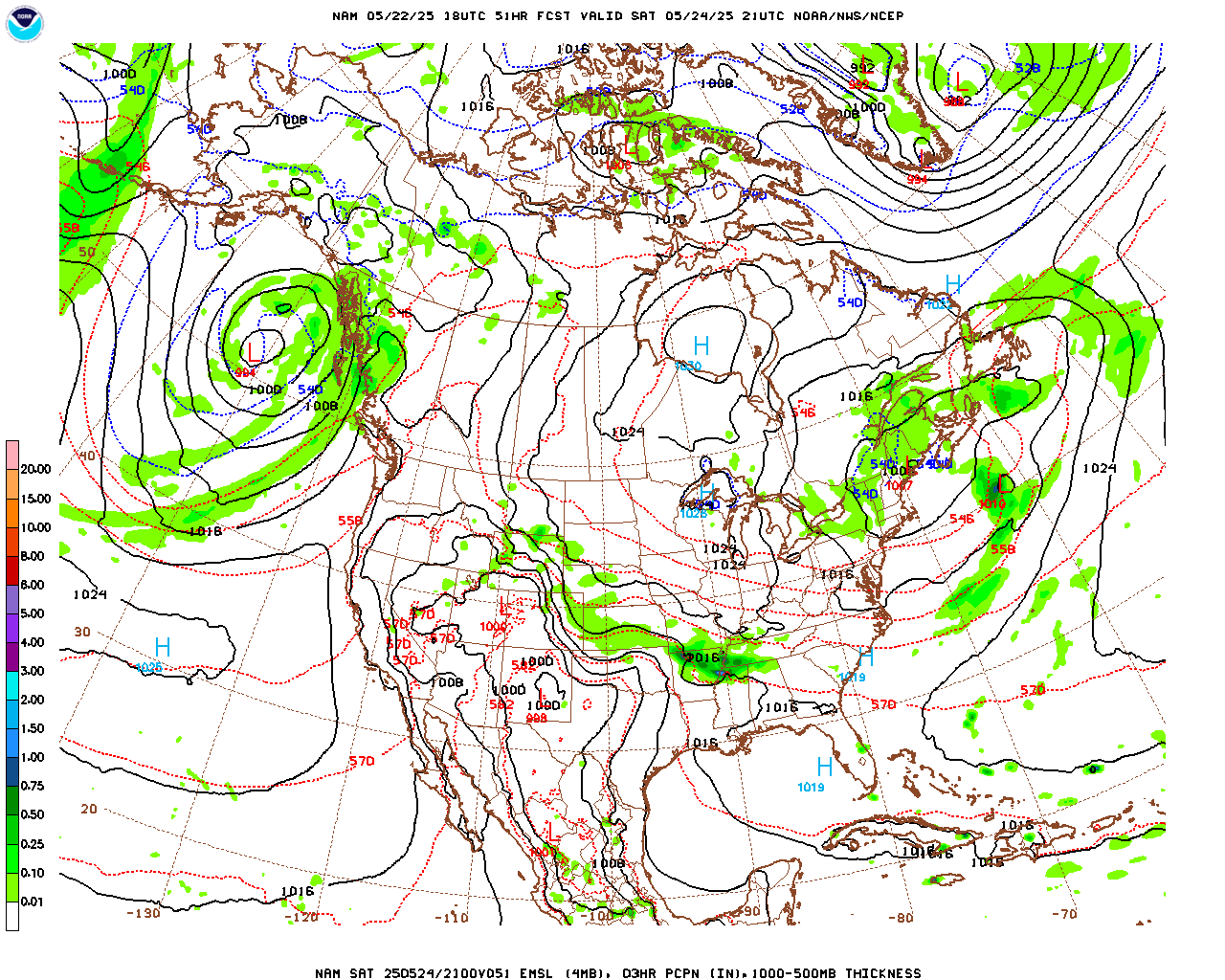
data/nam/18/nam_namer_051_1000_500_thick.gif

As of result of this low pressure system, a cold front will begin forming and making its way into our area Wednesday night into Thursday. Until then, enjoy the sunny skies and gorgeous weather as we begin our transition into Fall!

Bowling Green’s 3 Day Forecast:

  • Tonight: Mostly clear skies, low of 59 with a light north wind.
  • Monday: Sunny, high of 82, light north winds in the afternoon.
  • Monday Night: Mostly clear skies, low around 61, light north winds.
  • Tuesday: Mostly sunny skies, high near 85. Light south winds in the afternoon.
  • Tuesday Night: Partly cloudy skies, low around 68. Light south winds.
  • Wednesday: Partly sunny, with a high near 87. South winds.
  • Wednesday Night: Showers and thunderstorms likely with a 60% chance of rain. Mostly cloudy skies, with a low around 71.
Posted in Uncategorized | Comments Off on Sunny skies and more cool weather on the way!

A Little Rain and a Welcomed Cool Down

Today will be the last hot and humid day before a welcomed cold front swings through the area and provides some relief. Scattered pop up showers are possible this afternoon and evening as the front draws closer. More available moisture and better lifting just to our north and west will allow for more widespread showers across western Kentucky and north toward southern Illinois. The latest HRRR and RAP models are in pretty good agreement with the placement of rain this afternoon. This is the simulated reflectivity from the HRRR model for 4pm today.

hrrrMW_sfc_radar_007

Across the Bowling Green area we will see a 20% chance for a pop up thunderstorm this afternoon and a slightly better chance for a thunderstorm this evening. Thunderstorms will be spotty in nature, but any storm that does develop may not move very fast due to slow storm motion and could produce locally heavy rain. Isolated flooding events are not out of the question with this type of setup. In general, 0.25 – 0.5 inches of rain looks like a good bet across much of the area through Saturday evening.

d12_fill

Saturday

Saturday doesn’t look too promising if you were wanting to head outdoors. With on and off rain showers likely most of the day, you would be better off waiting until Sunday.

Sunday

With temperatures topping out around 80 degrees and partly sunny skies, Sunday will definitely be the pick of the weekend! Any leftover rain showers from the cold front will move out during the early morning hours of Sunday, leaving clearing skies throughout the afternoon.

Weekly Outlook

Daily rain chances enter the picture again by next Tuesday and will last through the end of the week. However, another cold front will arrive Thursday, bringing with it a taste of Fall!

Today: A 20 percent chance of showers and thunderstorms after 1pm. Mostly sunny, with a high near 89. South wind around 6 mph.
Tonight: A 30 percent chance of showers and thunderstorms, mainly after 4am. Partly cloudy, with a low around 71. South wind around 5 mph becoming calm in the evening.
Saturday: Showers and thunderstorms likely, mainly between 1pm and 4pm. Mostly cloudy, with a high near 86. Light and variable wind becoming northwest 5 to 7 mph in the morning. Chance of precipitation is 60%. New rainfall amounts between a quarter and half of an inch possible.
Saturday Night: A 30 percent chance of showers and thunderstorms, mainly before 7pm. Mostly cloudy, with a low around 65. North wind 5 to 7 mph.
Sunday: Partly sunny, with a high near 81. Northeast wind 6 to 8 mph.
Sunday Night: Partly cloudy, with a low around 59.
Monday: Mostly sunny, with a high near 82.
Monday Night: Partly cloudy, with a low around 65.
Tuesday: A 30 percent chance of showers and thunderstorms. Partly sunny, with a high near 85.
Tuesday Night: A 30 percent chance of showers and thunderstorms. Mostly cloudy, with a low around 68.
Wednesday: A 40 percent chance of showers and thunderstorms. Mostly cloudy, with a high near 83.
Wednesday Night: A 50 percent chance of showers and thunderstorms. Mostly cloudy, with a low around 69.
Thursday: A 50 percent chance of showers and thunderstorms. Mostly cloudy, with a high near 82.

Posted in Uncategorized | Comments Off on A Little Rain and a Welcomed Cool Down

Hot Weather, Summer Showers, And the Long Range Forecast

The average high this time of year for Bowling Green is near 84 degrees. The high temperature over the next few days will remain several degrees above average, but a slight cool down by the weekend will bring temps back to near normal.

Today

High’s today will top out around 90 degrees with an isolated thunderstorm possible. The best chances for rain will remain south and east of Bowling Green, but a 10% chance for a pop up shower seems like a good bet.

The Hi Resolution NAM tries to spit out some showers this afternoon in our area.

hiresNAM

Tonight

Temperatures will cool off into the upper 60s tonight with clear skies.

Tomorrow

Thursday will be a few degrees warmer with a high temperature topping out in the low 90s. Rain chances will also be on the increase with a 20% chance for a thunderstorm across the area.

Weekend Outlook

While the weekend doesn’t look like a total washout, rain is likely. The highest chance for rain will be Friday night through Saturday. However, Sunday will be quite dreamy with high temps in the low 80s and mostly sunny skies.

Long Term Forecast

In general, temperatures and precipitation will most likely remain above average for the next two weeks. The following maps from the Climate Prediction Center show the temperature and precipitation deviation from normal probabilities.

The first set of maps show the 6 – 10 day outlook.

610prcp.new 610temp.new


These next sets of maps show the 8 – 14 day outlook.

814prcp.new 814temp.new

The monthly outlook show near normal temperatures and precipitation should dominate the month.

off_temp_small

off_prcp_small

Overall, September will start out a little warmer than average with the possibility for more rain than normal. The highest chances for above average rainfall will shift north and west by the end of the month and the above average temperatures will remain along the Gulf and Atlantic coasts.

7 Day Outlook

Today: Mostly sunny, with a high near 89. Light and variable wind becoming northeast around 5 mph.
Tonight: Mostly clear, with a low around 68. Light southeast wind.
Thursday: A 20 percent chance of showers and thunderstorms after 1pm. Mostly sunny, with a high near 92. Calm wind becoming south around 6 mph in the morning.
Thursday Night: Partly cloudy, with a low around 71. Light south wind.
Friday: A 30 percent chance of showers and thunderstorms. Partly sunny, with a high near 91. Calm wind becoming southwest 5 to 7 mph in the morning.
Friday Night: A 40 percent chance of showers and thunderstorms. Mostly cloudy, with a low around 71.
Saturday: Showers and thunderstorms likely. Mostly cloudy, with a high near 84. Chance of precipitation is 60%.
Saturday Night: A 20 percent chance of showers and thunderstorms. Mostly cloudy, with a low around 65.
Sunday: Mostly sunny, with a high near 82.
Sunday Night: Partly cloudy, with a low around 60.
Monday: Mostly sunny, with a high near 82.
Monday Night: Partly cloudy, with a low around 64.
Tuesday: Mostly sunny, with a high near 87.

Posted in Uncategorized | Comments Off on Hot Weather, Summer Showers, And the Long Range Forecast

More Rain to End A Rainy Month

Bowling Green has already broken the August rainfall record and we still have more rain on the way for today! Bowling Green’s rain total for the month is 10.25 inches, with 1.9 inches falling over the past 24 hours. Here is a look at the monthly and yearly rainfall accumulation maps to show where south central Kentucky stands compared to normal.

These first two maps show the total monthly rainfall across the state and the departure from normal.

Month_to_date_Rainfall

Departure_from_Normal

The next two maps show the yearly rainfall and the departure from normal for the year.

Year_to_date_Rainfall

Year_to_date_Departure

Even with all the rain in Bowling Green a moderate drought continues across portions of the region. Far western Warren County stretching across much of western Kentucky have seen below average rainfall for the past few months. Thankfully, the slow and steady rainfall last night and this morning will help dampen the drought a bit across the area.


20140826_ky_none

Today’s Forecast

The morning and early afternoon will be mainly wet. By mid afternoon the bulk of the rain looks to move out of the area. The simulated reflectivity from the HRRR shows some pockets of heavier rain trying to push through around lunch before finally moving out later this afternoon.

lunch

dinner The clouds and rain will help keep it cooler across the region today with high temperatures topping out around 81 degrees.

Weekly Forecast

Temperature will remain seasonable, topping out in the upper 80’s to near 90 each day. Summer showers and storms are also possible each day this week with the best chance coming on Tuesday. No day will be a washout, but some storms will bring heavy rain to areas. The 7 day rainfall forecast from the WPC shows an additional 1 – 2 inches of rain is possible this week.

p168i

7 Day Forecast

Today: Occasional showers and possibly a thunderstorm, mainly before 3pm, then a chance of showers and thunderstorms after 3pm. High near 81. Southwest wind 9 to 11 mph. Chance of precipitation is 80%. New rainfall amounts between a half and three quarters of an inch possible.

Tonight: A slight chance of showers and thunderstorms before midnight, then a slight chance of showers and thunderstorms after 2am. Mostly cloudy, with a low around 70. South wind 5 to 8 mph. Chance of precipitation is 20%.

Labor Day: A 20 percent chance of showers and thunderstorms. Partly sunny, with a high near 89. Southwest wind 7 to 13 mph.

Monday Night: A 30 percent chance of showers and thunderstorms, mainly after 1am. Mostly cloudy, with a low around 71. South wind 5 to 8 mph.

Tuesday: Showers and thunderstorms likely. Mostly cloudy, with a high near 88. Southwest wind 5 to 9 mph. Chance of precipitation is 60%. New rainfall amounts between a quarter and half of an inch possible.

Tuesday Night: A 30 percent chance of showers and thunderstorms. Mostly cloudy, with a low around 70.

Wednesday: A 30 percent chance of showers and thunderstorms. Partly sunny, with a high near 87.

Wednesday Night: A 20 percent chance of showers and thunderstorms. Mostly cloudy, with a low around 70.

Thursday: A 30 percent chance of showers and thunderstorms. Partly sunny, with a high near 90.

Thursday Night: A 20 percent chance of showers and thunderstorms. Mostly cloudy, with a low around 71.

Friday: A 30 percent chance of showers and thunderstorms. Partly sunny, with a high near 91.

Friday Night: A 20 percent chance of showers and thunderstorms. Mostly cloudy, with a low around 70.

Saturday: A 40 percent chance of showers and thunderstorms. Partly sunny, with a high near 91.


Posted in Uncategorized | Comments Off on More Rain to End A Rainy Month

Chase Day 13 & Return Trip

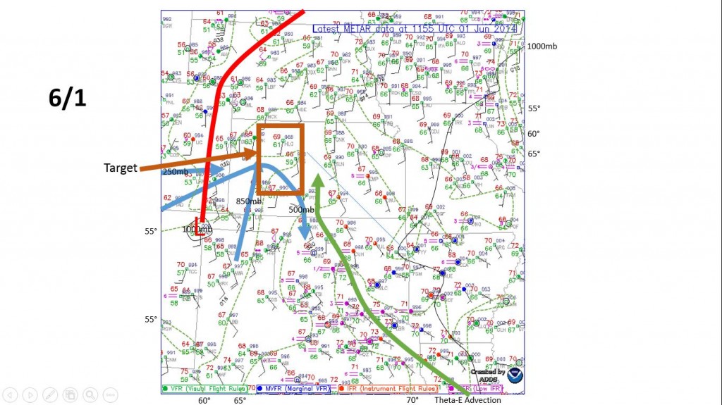
On Sunday we started our day in Ogallala, Nebraska and prepared for what we hoped would turn out to be one of our better chase days. The setup featured a split flow aloft with a surface low moving across western Kansas. This would provide the lift for storms to fire across the western part of state before congealing into a line and moving east. Wind shear was weak in the lower levels but the CAPE was progged to have values of 1500-2500 J/kgK and storms were expected to produce mainly large hail, damaging winds, and isolated tornadoes. Here is a look at Sunday’s surface analysis:

61sfcanalysis

We departed pretty early from Ogallala and headed about 3 hours south to a small town called Norton, Kansas which sits right along the Kansas/Nebraska border. We ate some Subway for lunch and even ran into our friends from the College of DuPage once again. This also gave us a chance to check on the short range models to get an update of what was going on with the storms. Ongoing in convection in southern Nebraska was still present and supercells that were forecast to pop up over the western part of the state and congeal into a line were looking to happen too late in the day to chase. So we decided to try and chase the strongest storm on the southern edge of the ongoing convection in northern Kansas.

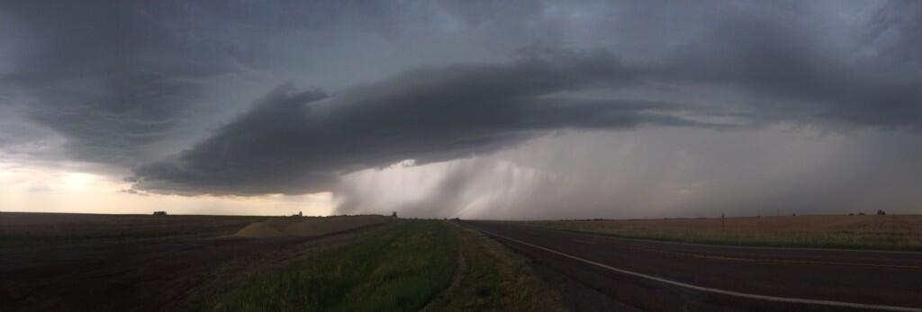
We targeted the strongest storm pretty well and left Subway, but even the strongest storm was not impressive once we reached it. We caught the storm in Philippsburg, Kansas where it became severe thunderstorm warned. Then we followed the storm to Athol, Kansas and got a view of the severe storm.

elevatedAthol

This storm was elevated and receiving none of its inflow from the surface. Even though it looked pretty impressive in person and on radar, this storm was not very strong and was only going to produce small hail before losing strength. We left the storm and headed west to Hays, Kansas to see if any storms fired a bit earlier than expected but unfortunately none did.

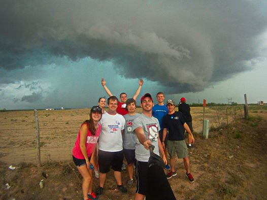
This would mark the end of our chasing and we headed east to Salina to drop off Dr. Dixon and then we headed east ourselves to the hotel in Boonville, Missouri. Yesterday we woke up early and drove from Boonville to Bowling Green and returned to campus. After 14 days traveling, 6 states covered, and a total of 8,311 miles (avg. 547 miles per day) we have returned from an amazing storm chase. Here is another group picture of all of us on Day 6 in Texas.  (including Dr. Durkee in the background):

studentpicture


Posted in Uncategorized | Comments Off on Chase Day 13 & Return Trip

Chase Day 12

We arose bright and early today in Spearfish, SD and took off southwest.  Looking over the models while chowing down on some delicious breakfast, we determined the primary mission today was a “travel day” to Ogallala, NE in order to get in a good position for tomorrow’s promising weather.  Nonetheless, our target area entailing the boundary of Wyoming/Nebraska just so happened to be along the way giving us something to look forward to.

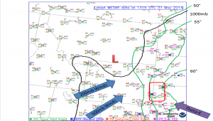
The weather set-up for today was pretty far from ideal though.  Adequate dewpoints with a shortwave trough positioned over the region meant storms had the fuel and the lifting mechanism to fire up.  Unfortunately, upper level support (i.e. speed, shear, helicity) was lacking.  Because of this, storms were rather weak and the structure was clustered instead of solo supercells.

sfc map

Surface Map

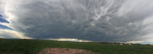
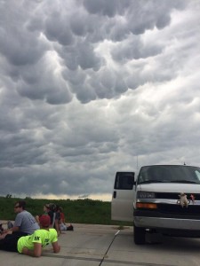
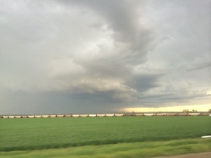
After reaching our target area we set up base camp in Lusk, Wyoming.  We ate lunch at the Outpost Café (I give it a 4/5 rating, if you are ever in the area looking for some good grub) and played some football at the local park.  Chase teams from Rutgers University and the College of DuPage were also at the park playing the waiting game.  Around 4pm MDT moderately impressive storms fired up around the region.  We viewed one storm from Lusk and then chased another around the town of Torrington, Nebraska.

Storm as viewed from Lusk, WY

Storm as viewed from Lusk, WY

Mammatus clouds from Lusk storm

Mammatus clouds from Lusk storm

Torrington Storm

Torrington Storm

The chasing soon ended as the storms weakened and clustered together soon after 6pm.  We finished the drive to Ogallala, NE where we are currently catching some ZZZ’s.

Posted in Uncategorized | Comments Off on Chase Day 12